Chaiya district
|
Amphoe Chaiya อำเภอ ไชยา |
|
|---|---|
| Province: | Surat Thani |
| Surface: | 1010.9 km² |
| Residents: | 49,903 (2012) |
| Population density : | 46.49 U / km² |
| ZIP : | 84110 |
| Geocode : | 8406 |
| map | |

|
|
Amphoe Chaiya ( Thai อำเภอ ไชยา ) is a district ( Amphoe - administrative district) in Surat Thani Province , which is part of the southern region of Thailand .
Chaiya is one of the oldest and most historically significant places in southern Thailand. The county’s administrative seat is Talat Chaiya .
geography
Chaiya is located on the Gulf of Thailand , Cape Sui ( แหลม ซุย - Laem Sui ) represents the northern end of the Bay of Bandon . The eastern part of the district consists mainly of a flat, low-lying coastal strip, the west is from the mountains of Dominated Phuket Mountain Range . The Kaeng Krung National Park is also located in them .
Neighboring districts are (from the south clockwise) the Amphoe Tha Chang in the province of Surat Thani, Amphoe Kapoe in the province of Ranong , Amphoe Phato in the province of Chumphon and Amphoe Tha Chana again in Surat Thani. In the east lies the Gulf of Thailand , Cape Sui ( แหลม ซุย ) is the northern end of the Bay of Bandon .
history
The city of Chaiya was one of the most important cities, possibly a capital of the Buddhist maritime empire Srivijaya , which ruled the south of the Malay Peninsula and Sumatra from the 7th to the 13th centuries. Numerous perfectly shaped Buddha statues from that era were found here , which can now be seen in the Chaiya National Museum. Other statues can be found in the National Museum Bangkok .
Because of its geostrategically favorable location on the Gulf of Thailand, the port has always played an important role in east-west trade between India , the Malay Peninsula and China .
religion
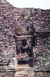
In Amphoe Chaiya, close to the main town Talat Chaiya , there is the important Buddhist temple Wat Borommathat Chaiya from the 8th century. The central chedi was built with bricks and mortar made from vegetable fibers. The complex was restored quite extensively in the 1990s.
Another attraction is the Suan Mokkh Buddhist meditation center , located about six kilometers to the southwest of the city. The center was founded by Buddhadasa Bhikkhu , who died in 1993 and who also came from Amphoe Chaiya. The basic idea is the simple life, which gets by without major religious ceremonies and is here also combined with physical work. The meditation cycles start on the first day of each month and last for 10 days. They are visited by Buddhists from all over the world.
economy
There are numerous shrimp farms on the coast of Chaiya .
administration
Provincial Administration
Amphoe Chaiya is divided into nine communities ( tambon ) , which are further divided into 54 villages ( muban ) .
|
Local administration
There are three small towns ( Thesaban Tambon ) in the district:
- Talat Chaiya ( เทศบาล ตำบล ตลาด ไชยา ) consists of parts of the Tambon Talat Chaiya and parts of Lamet,
- Phumriang ( เทศบาล ตำบล พุมเรียง ) consists of parts of the tambon of the same name ,
- Wiang ( เทศบาล ตำบล เวียง ) consists of the entire tambon of the same name .
There are also six " Tambon Administrative Organizations " ( für บริหาร ส่วน ตำบล - Tambon Administrative Organizations, TAO) for the tambon or the parts of tambon in the county that do not belong to any city.
Web links
- More details on Amphoe Chaiya from amphoe.com (Thai)
- Information on the retreat at Wat Suan Mokkh (English)
Individual evidence
- ↑ Population statistics 2012 . Department of Provincial Administration. Retrieved July 13, 2014.
Coordinates: 9 ° 23 ' N , 99 ° 12' E


