Amphoe Khian Sa
|
Khian Sa เคียน ซา |
|
|---|---|
| Province: | Surat Thani |
| Surface: | 583.6 km² |
| Residents: | 47,197 (2012) |
| Population density : | 73.03 E./km² |
| ZIP : | 84260, 84210 |
| Geocode : | 8414 |
| map | |

|
|
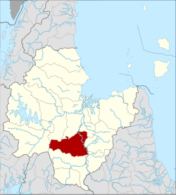
Amphoe Khian Sa ( Thai : อำเภอ เคียน ซา ) is a district ( amphoe - administrative district) in Surat Thani Province . The Surat Thani Province is located in the southern region of Thailand .
geography
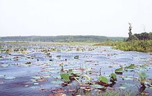
Amphoe Khian Sa is about 60 kilometers away from the provincial capital Surat Thani. It is located in the Khian Sa Basin, through which the Maenam Tapi flows. The river also forms the eastern border of the district. It is quite swampy along the river, best seen in the Nong Thung Thong swamp ( หนอง ทุ่ง ทอง ).
The neighboring Amphoe are (clockwise from north): Khiri Rat Nikhom , Phunphin , Ban Na Doem , Ban Na San , Wiang Sa , Phrasaeng and Phanom .
economy
Rice is mainly grown in Khian Sa, and plantations of latex trees are just as common.
traffic
The highway 44, the Krabi with the Amphoe Khanom the Nakhon Si Thammarat connects the main artery of the district.
history
Khian Sa was founded on December 15, 1970 initially as a subdistrict ( King Amphoe ) by separating the two tambon Khian Sa and Phuang Phromkhon from the Ban Na San district . It received full Amphoe status on May 20, 1974.
administration
Provincial Administration
The Amphoe Khian Sa is divided into five sub-districts ( tambon ) , which in turn have a total of 52 communities ( muban ) .
|
Local administration
There are two small towns ( Thesaban Tambon ) in the county:
- Khian Sa ( เทศบาล ตำบล เคียน ซา ) consists of part of the Tambon Khian Sa,
- Ban Sadet ( เทศบาล ตำบล บ้าน เสด็จ ) consists of the entire tambon Ban Sadet.
There are also four "Tambon Administrative Organizations " ( องค์การ บริหาร ส่วน ตำบล - Tambon Administrative Organizations, TAO) for the Tambon or the parts of Tambon in the district that do not belong to any city.
Individual evidence
- ↑ ประกาศ กระทรวง มหาดไทย เรื่อง แบ่ง ท้องที่ ตั้ง เป็น กิ่ง อำเภอ กิ่ง อำเภอ เคียน ซา Royal Gazette, Vol. 87, Ed. 116 ง , December 15, 1970, p. 3512 (in Thai)
- ↑ พระราชกฤษฎีกา ตั้ง อำเภอ เขาวง อำเภอ เชียงม่วน อำเภอ ดอนตาล อำเภอ ชาติตระการ อำเภอ ภูเรือ อำเภอ เคียน ซา อำเภอ น้ำโสม อำเภอ หนองวัวซอ และ อำเภอ น้ำยืน พ.ศ. ๒๕๑๗ Royal Gazette, Vol. 91, Ed. 54 ก special ( ฉบับ พิเศษ ), pp. 30–33 of March 28, 1974 (in Thai)
- ↑ Population statistics 2012 . Department of Provincial Administration. Retrieved July 13, 2014.
Web links
Coordinates: 8 ° 50 ' N , 99 ° 12' E


