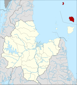
Amphoe Ko Pha-ngan
|
Ko Pha-ngan เกาะพะงัน |
|
|---|---|
| Province: | Surat Thani |
| Surface: | 194.3 km² |
| Residents: | 15,546 (2012) |
| Population density : | 50.8 U / km² |
| ZIP : | 84280 |
| Geocode : | 8405 |
| map | |

|
|
Amphoe Ko Pha-ngan ( Thai : อำเภอ เกาะพะงัน ) is a district ( Amphoe - administrative district) in the northeast of Surat Thani Province . The Surat Thani Province is located in the southern region of Thailand . The district consists of the islands of Ko Pha-ngan and Ko Tao , located off the east coast of the Malay Peninsula in the Gulf of Thailand , and a number of smaller islands.
geography
The island of Ko Pha-ngan is located 60 kilometers east of mainland Thailand . It is the second largest island of the Samui archipelago ( Mu Ko Samui ), which is named after the neighboring island of Ko Samui , located about 15 km to the southwest (which, however, belongs to the district (Amphoe) Ko Samui with some other islands ). Amphoe Ko Pha-ngan also includes the islands Ko Tao and Ko Nang Yuan . Directly off the coast of Ko Pha-ngan there are a number of very small (about 1 km² and smaller) uninhabited islands, such as Ko Tae Nok and Ko Tae Nai in the west, Ko Ma in the northwest or Ko Kong Than Sadet in the east.
The interior of the main island is largely mountainous and covered by primeval forest and partly by secondary forest. The highest mountain is the 635 m high Khao Ra in the north of the island. Thong Sala ( ท้อง สา ลา ) is the main port.
economy
Both Ko Pha-ngan and Ko Tao and even the small Ko Nang Yuan are shaped by tourism. The surroundings of the islands are considered attractive diving areas . Therefore, a large number of diving schools and beach resorts are located here.
administration
Provincial Administration
Amphoe Ko Pha-ngan is divided into three communities ( Tambon ) , which in turn are divided into 17 villages ( Muban ) .
|
Local administration
There are a total of four municipalities with "small town" status ( Thesaban Tambon ) in the district:
- Ko Pha-ngan ( เทศบาล ตำบล เกาะพะงัน ) consists of parts of the tambon Ko Pha-ngan and Ban Tai,
- Ban Tai ( เทศบาล ตำบล บ้าน ใต้ ) consists of further parts of the Tambon Ban Tai,
- Phet Pha-ngan ( เทศบาล ตำบล เพชร พะ งัน ) consists of further parts of the Tambon Ko Pha-ngan,
- Ko Tao ( เทศบาล ตำบล เกาะ เต่า ) consists of the entire tambon Ko Tao.
Individual evidence
- ↑ Population statistics 2012 . Department of Provincial Administration. Retrieved July 13, 2014.
Web links
Coordinates: 9 ° 43 ' N , 100 ° 0' E


