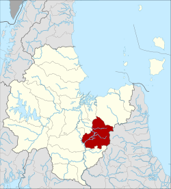
Ban Na San district
|
Ban Na San บ้านนาสาร |
|
|---|---|
| Province: | Surat Thani |
| Surface: | 839.3 km² |
| Residents: | 69,993 (2012) |
| Population density : | 81.4 U / km² |
| ZIP : | 84120, 84240, 84270 |
| Geocode : | 8412 |
| map | |

|
|
Ban Na San ( Thai : บ้านนาสาร ) is a district ( amphoe - administrative district) in the southeast of Surat Thani Province . The province of Surat Thani is located in the southern region of Thailand, about 650 km south of Bangkok on the east coast of the Malay Peninsula to the Gulf of Thailand .
geography
Neighboring districts (clockwise from the east): the Amphoe Nopphitam and Phipun in the province of Nakhon Si Thammarat and the Amphoe Wiang Sa , Khian Sa , Ban Na Doem , Mueang Surat Thani and Kanchanadit in the province of Surat Thani.
In the east of the district are the hilly foothills of the Nakhon-Si-Thammarat mountain range , there is the Tai Rom Yen National Park .
history
The history of the district goes back to the time of Lamphun County, which was formerly the administrative unit of the southeastern part of today's Surat Thani Province. He was originally in seven Tambon divided - Ban Na Tha Ruea ( ท่าเรือ ) Kobkaeb ( กอบ แก บ ), Thung Tao, I-Panm ( อิ ปัน ) Prasaeng and Phanom. In 1899 the southern part was made Phrasaeng District and Subdistrict ( King Amphoe ) Phanom.
Originally the district was administered from Nakhon Si Thammarat, in 1906 it was transferred to Chaiya (now Surat Thani).
On April 29, 1918, the district was renamed Ban Na, after the place where the administration was located. On July 1, 1938, the administration was moved to Na San and finally renamed to Ban Na San on April 20, 1939.
In the 1970s, the size of the circle further reduced when today's Amphoe Khian Sa, Wiang Sa and Ban Na Doem were separated.
Sons and daughters
- Jatuporn Prompan , politician and activist
administration
Provincial Administration
Amphoe Ban Na San is divided into 11 communities ( tambon ) , which in turn are divided into 65 villages ( muban ) .
|
Local administration
Na San ( เทศบาล เมือง นา สาร ) is the name of a town ( Thesaban Mueang ) in the district, it consists of the entire Tambon Na San.
There are also four small towns ( Thesaban Tambon ) :
- Phru Phi ( เทศบาล ตำบล พรุ พี ) consists of the entire Tambon hru Phi,
- Khlong Prap ( เทศบาล ตำบล คลอง ปราบ ) consists of the entire Tambon Khlong Prap,
- Tha Chi ( เทศบาล ตำบล ท่า ชี ) consists of the entire Tambon Tha Chi,
- Khuan Si ( เทศบาล ตำบล ควน ศรี ) consists of the entire tambon Khuan Si.
There are also six "Tambon Administrative Organizations" (TAO, องค์การ บริหาร ส่วน ตำบล - administrative organizations) for the tambon in the district that do not belong to any city.
Individual evidence
- ↑ แจ้ง ความ กระทรวง มหาดไทย. เรื่อง โอน ท้องที่ อำเภอ ลำพูน ๑ อำเภอ พนม ๑ อำเภอ พะ แสง ๑ รวม สาม อำเภอ จาก เขต เมือง นครศรีธรรมราช มา ขึ้น เมือง ไชยา มณฑล ชุมพร . (PDF) In: Royal Gazette . 23, No. 18, July 29, 1906, pp. 408-409. Retrieved March 21, 2014.
- ↑ พระราชกฤษฎีกา เปลี่ยน นาม อำเภอ กิ่ง อำเภอ และ ตำบล บาง แห่ง พุทธศักราช ๒๔๘๒ . (PDF) In: Royal Gazette . 56, No. 0 ก , April 17, 1939, pp. 354-364. Retrieved March 21, 2014.
- ↑ Population statistics 2012 . Department of Provincial Administration. Retrieved March 21, 2014.
Web links
Coordinates: 8 ° 48 ' N , 99 ° 22' E

