
Amphoe Phunphin
|
Phunphin พุนพิน |
|
|---|---|
| Province: | Surat Thani |
| Surface: | 1,240 km² |
| Residents: | 92,000 (2012) |
| Population density : | 76 U / km² |
| ZIP : | 84130 |
| Geocode : | 8417 |
| map | |

|
|
Amphoe Phunphin ( Thai : อำเภอ พุนพิน ) is a district ( amphoe - administrative district) in Surat Thani Province . The Surat Thani Province is located in the southern region of Thailand .
geography
The neighboring counties and areas are (clockwise from north): the Amphoe Tha Chang , Mueang Surat Thani , Ban Na Doem , Khian Sa , Khiri Rat Nikhom and Vibhavadi ; all counties belong to Surat Thani Province. Phunphin also has a short coastline to Bandon Bay in the northeast .
The largest rivers in the county are the Maenam Tapi and its tributary Phum Duang, which flows into the Tapi near Tha Kham town.
history
The county was renamed from Tha Kham to Phunphin in 1939.
Public transport
Phunphin County is a public transport hub in Surat Thani Province. On the southern line of the Thai State Railroad , it has a total of three stations, four railway stops and a junction. The province's main train station, Surat Thani Station, is located in Tambon Tha Kham in that district. The city of Surat Thani itself is not connected to the railway line. At the Ban Thung Pho Junction at kilometer 631, there is a turnoff to the formerly planned station in the district of Takua Thung of Phang Nga province , just across from Phuket . After the first 31 km to Khiri Ratthanikhom had been completed in 1956, the project was put on hold due to financial difficulties.
The Amphoe Phunphin is also home to Surat Thani Airport , the "Inland Container Depot" (ICD) and the "Asian Highway" AH2 as the main connection to the other provinces of Thailand.
photos
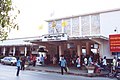
In front of the main train station, Phunphin

On the platform, Phunphin train station


administration
Provincial Administration
Amphoe Phunphin is divided into 16 communities ( tambon ) , which are further subdivided into 98 villages ( muban ) .
|

Local administration
The city ( Thesaban Mueang ) Tha Kham ( เทศบาล เมืองท่า ข้าม ) includes parts of the Tambon Tha Kham.
There are also 17 “Tambon Administrative Organizations ” ( องค์การ บริหาร ส่วน ตำบล - Tambon Administrative Organizations, TAO) for the Tambon or parts of Tambon in the district that do not belong to any city.
Individual evidence
- ↑ พระราชกฤษฎีกา เปลี่ยน นาม อำเภอ กิ่ง อำเภอ และ ตำบล บาง แห่ง พุทธศักราช ๒๔๘๒ . In: Royal Gazette . 56, No. 0 ก , April 17 1939, pp. 354-364.
- ↑ Population statistics 2012 . Department of Provincial Administration. Retrieved July 13, 2014.
Web links
- More information about Amphoe Phunphin from amphoe.com (in Thai)
- Thakham City Council (Phunphin) (in Thai)
Coordinates: 9 ° 7 ' N , 99 ° 14' E

Mueang Surat Thani | Ban Na Doem | Ban Na San | Ban Ta Khun | Chai Buri | Chaiya | Don Sak | Kanchanadit | Khian Sa | Khiri Council Nikhom | Ko Pha-ngan | Phanom | Phrasaeng | Phunphin | Ko Samui | Tha Chana | Tha Chang | Wiang Sa | Vibhavadi