Takua Thung district
|
Takua Thung ตะกั่วทุ่ง |
|
|---|---|
| Province: | Phang Nga |
| Surface: | 610.8 km² |
| Residents: | 42,822 (2012) |
| Population density : | 66.1 U / km² |
| ZIP : | 82130, 82140 |
| Geocode : | 8204 |
| map | |

|
|
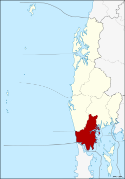
Amphoe Takua Thung ( Thai : อำเภอ ตะกั่วทุ่ง ) is a district ( amphoe - administrative district) in Phang Nga Province . Phang Nga Province is located in the northwest of the southern region of Thailand .
geography
Neighboring counties and areas are (clockwise from north): Amphoe Thai Mueang and Amphoe Mueang Phang Nga , Phang Nga Province. In the southwest is the bay of Phang Nga (Phang Nga Bay) , in the south - separated by the Pak Phra Strait (Pak Phra Strait) - is Amphoe Thalang in the province of Phuket . To the west is the Andaman Sea .
The nature reserve Namtok Raman (Namtok Raman Forest Park) protects about 0.2 km² around a scenic waterfall (Thai: namtok ). The area was established on October 26, 1983. Most of the coast to Phang Nga Bay is in the Ao Phang Nga National Park .
history
Mueang Takua Thung is an ancient city, just like Phang Nga and Takua Pa. The old administration was in Ban Khai, Tambon Bang Thong, in Amphoe Thai Mueang . When Burmese forces attacked Mueang Takua Pa in 1894, Thalang and Takua Thung were the next targets. Therefore, the residents of Takua Thung moved the administration to Tambon Kra Som, where it is still located today.
Takua Thung was demoted to part of Phang Nga Province in 1899.
Attractions
- Nature experience - landscape and coast of Phang Nga Bay
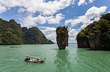
- James Bond Island: On the overland route from Phuket to Krabi, north around Phang Nga Bay, Phang Nga town is in the middle of the route. Tour operators offer boat trips to the islands of the river delta here. The center of tourist interest is Khao Phing Kan , the island with the distinctive rock finger, which is blown up at the end of the James Bond film The Man with the Golden Gun and sinks into the sea, but can still be visited today. The island is located in the Ao Phang-nga National Park.
- The most important Buddhist temple ( Wat ) of the district is Wat Suwannakhuha, which is also known as Wat Tham (literally cave temple ), as there are numerous caves in the temple area. In the largest of them, there are stalagmites and stalactites as well as numerous Buddha images .
administration
Provincial Administration
Amphoe Takua Thung is divided into seven subdistricts ( tambon ) , which are further subdivided into 68 village communities ( muban ) .
|
Local administration
There are two small towns ( Thesaban Tambon ) in the county:
- Krasom ( เทศบาล ตำบล กระ โสม ) consists of parts of the Tambon Krasom,
- Khok Kloi ( เทศบาล ตำบล โคก กลอย ) consists of parts of the tambon Khok Kloi.
There are also seven “tambon administrative organizations” (TAO, องค์การ บริหาร ส่วน ตำบล ) for the tambon or the parts of tambon in the county that do not belong to any town.
Individual evidence
- ↑ Official website of the Ao Phang-nga National Park ( Memento of the original from October 20, 2014 in the Internet Archive ) Info: The archive link has been inserted automatically and has not yet been checked. Please check the original and archive link according to the instructions and then remove this notice. (in English)
- ↑ Population statistics 2012 . Department of Provincial Administration. Retrieved July 11, 2014.
Web links
Coordinates: 8 ° 24 ' N , 98 ° 27' E


