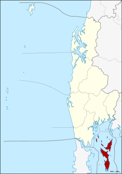
Ko Yao district
|
Ko Yao เกาะยาว |
|
|---|---|
| Province: | Phang Nga |
| Surface: | 141.06 km² |
| Residents: | 13,574 (2012) |
| Population density : | 90.3 U / km² |
| ZIP : | 82160, 83000 |
| Geocode : | 8202 |
| map | |

|
|
Amphoe Ko Yao ( Thai : อำเภอ เกาะยาว ) is a district ( amphoe - administrative district) in Phang Nga Province . The Phang Nga Province is located in the southern region of Thailand .
geography
The district consists of several islands of the Ko Yao Archipelago in Phang Na Bay, east of Phuket Island . The two largest islands are called Ko Yao Yai (Big Long Island) and Ko Yao Noi (Small Long Island) .
The northern islands are part of the Ao Phang Nga National Park .
Demographics
The majority of the population are Sunnis . Islam was introduced by Arab traders in the 13th century.
history
Ko Yao was initially established as a small district ( King Amphoe ) in 1903 . It was part of Mueang Phang Nga County . On January 1, 1988, Ko Yao was promoted to a full Amphoe.
administration
Provincial Administration
Amphoe Ko Yao is divided into three sub-districts ( tambon ) , which are further subdivided into 18 village communities ( muban ) .
|
Local administration
There are three small towns ( Thesaban Tambon ) in the county:
- Ko Yao ( เทศบาล ตำบล เกาะยาว ) consists of parts of the Tambon Ko Yao Noi.
- Phru Nai ( เทศบาล ตำบล พรุ ใน ) consists of the whole tambon Phru Nai.
- Ko Yao Yai ( เทศบาล ตำบล เกาะยาว ใหญ่ ) consists of the whole tambon Ko Yao Yai.
The remaining parts of the Tambon Ko Yao Noi that do not belong to the city are administered by a “Tambon Administration Organization” (TAO, องค์การ บริหาร ส่วน ตำบล ).
Individual evidence
- ↑ พระราชกฤษฎีกา ตั้ง อำเภอ นาม น อำเภอ พระยืน อำเภอ หนองบัว ระ เหว อำเภอ บ้านเหลื่อม อำเภอ จะ แนะ อำเภอ หนอง หงส์ อำเภอ นา โพธิ์ อำเภอ เกาะยาว อำเภอ อำเภอ แกดำ อำเภอ สระ โบสถ์ อำเภอ อำเภอ โนน คูณ อำเภอ ควนโดน อำเภอ ไชยวาน อำเภอ หนอง แสง และ อำเภอ ตาล สุม พ.ศ. ๒๕๓๐ Royal Gazette, Volume 104, Ed. 278 ก special ( ฉบับ พิเศษ ) of December 31, 1987, pp. 33–37 (in Thai)
- ↑ Population statistics 2012 . Department of Provincial Administration. Retrieved July 11, 2014.
Web links
Coordinates: 8 ° 7 ' N , 98 ° 35' E

