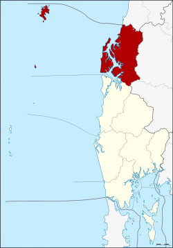
Amphoe Khura Buri
|
Khura Buri คุระบุรี |
|
|---|---|
| Province: | Phang Nga |
| Surface: | 797.1 km² |
| Residents: | 26,397 (2012) |
| Population density : | 29.2 U / km² |
| ZIP : | 82150 |
| Geocode : | 8206 |
| map | |

|
|
Amphoe Khura Buri ( Thai : อำเภอ คุระบุรี ) is a district ( Amphoe - administrative district) in Phang Nga Province . The Phang Nga Province is located in the southern region of Thailand .
geography
The district is located on the coast of the Andaman Sea and is the northernmost district of Phang Nga Province. In the south of the district is the Si Phang-nga National Park . The two national parks Mu Koh Similan and Mu Koh Surin are just off the coast .
Khura Buri District is bounded by the following districts (from north clockwise as seen): Suk Samran District of Ranong province , the Amphoe Ban Ta Khun and Phanom of Surat Thani province and Takua Pa District Phang Nga province.
history
Originally, the area of today's county was the main district of Takua Pa Province, so it was called Amphoe Mueang Takua Pa. In 1913 the administration was relocated to today's city of Takua Pa, and the district was renamed Ko Kho Khao after its central tambon . The following year the district was renamed Pak Nam, but this was reversed in 1917. On September 1, 1938, the district was then downgraded to a small district ( King Amphoe ) . After the administration was moved to Tambon Khura in 1964 , the district was renamed Khura Buri in 1968. On August 8, 1975, Khura Buri then got full amphoe status.
The tambon Ko Kho Khao, which was originally the center of the district, was assigned to Takua Pa on December 28, 1988.
administration
Provincial Administration
Amphoe Khura Buri is divided into four subdistricts ( tambon ) , which are further subdivided into 33 village communities ( muban ) .
|
Note: The missing GeoCode 4 was assigned to the tambon Ko Kho Khao, which was assigned to the Amphoe Takua Pa.
Local administration
Khura Buri ( เทศบาล ตำบล คุ ระบุ ร ) is a small town ( Thesaban Tambon ) in the district, it consists of parts of the Tambon Khura and Mae Nang Khao.
There are also four "Tambon Administration Organizations" (TAO, องค์การ บริหาร ส่วน ตำบล ) for the Tambon or the parts of Tambon in the county that do not belong to any town.
Individual evidence
- ↑ แจ้ง ความ กระทรวง มหาดไทย เรื่อง เปลี่ยน นาม อำเภอ เมือง ๆ เก่า เมือง ตะกั่วป่า เป็น อำเภอ เกาะ คอ เฃา Royal Gazette, Volume 30, Edition 0 ง of September 28, 1913, p. 576 (in Thai)
- ↑ แจ้ง ความ กระทรวง มหาดไทย เรื่อง เปลี่ยน ชื่อ อำเภอ เกาะ คอ เขา เป็น อำเภอ ปากน้ำ Royal Gazette, Volume 30, Ed. 0 ง of February 1, 1914, p. 2574 (in Thai)
- ↑ ประกาศ กระทรวง มหาดไทย เรื่อง เปลี่ยน ชื่อ อำเภอ Royal Gazette, Volume 34, Issue 0 ก of April 1, 1917, pp. 40–68 (in Thai)
- ↑ ประกาศ สำนัก นายกรัฐมนตรี เรื่อง ยุบ รวม อำเภอ และ ยุบ อำเภอ ลง เป็น กิ่ง อำเภอ Royal Gazette, Volume 55, Ed. 0 ง of August 29, 1938, p. 1840 (in Thai)
- ↑ ประกาศ กระทรวง มหาดไทย เรื่อง การ ย้าย ที่ว่าการ กิ่ง อำเภอ เกาะ คอ เขา . In: Royal Gazette . 81, No. 116 ง , December 8, 1964, p. 2935.
- ↑ พระราชกฤษฎีกา เปลี่ยน ชื่อ กิ่ง อำเภอ และ ตำบล บาง แห่ง พ.ศ. ๒๕๑๑ Royal Gazette, Volume 85, Ed. 98 ก October 29, 1968, pp. 774–777 (in Thai)
- ↑ พระราชกฤษฎีกา ตั้ง อำเภอ แวงน้อย อำเภอ ป่าแดด อำเภอ เรณูนคร อำเภอ คูเมือง อำเภอ คุระบุรี อำเภอ แม่ลาน้อย อำเภอ เสริมงาม อำเภอ อำเภอ ไพรบึง และ อำเภอ หนองโดน พ.ศ. ๒๕๑๘ Royal Gazette, Volume 92, Ed. 166 ก ฉบับ พิเศษ (special) from August 21, 1975, pp. 1–4 (in Thai)
- ↑ พระราชกฤษฎีกา เปลี่ยนแปลง เขต อำเภอ คุระบุรี กับ อำเภอ ตะกั่วป่า จังหวัด พังงา พ.ศ. ๒๕๓๑ Royal Gazette, Volume 105, Ed. 239 ก ฉบับ พิเศษ (special) of December 30, 1988, pp. 13–15 (in Thai)
- ↑ Population statistics 2012 . Department of Provincial Administration. Retrieved July 11, 2014.
Web links
- More information about Amphoe Khura Buri from amphoe.com (in Thai)
- Information about the National Park Mu Ko Surin (in English)
- Information on the Si Phang-nga National Park (in English)
Coordinates: 9 ° 12 ' N , 98 ° 25' E

