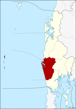
Amphoe Thai Mueang
|
Thai Mueang ท้ายเหมือง |
|
|---|---|
| Province: | Phang Nga |
| Surface: | 611.8 km² |
| Residents: | 47,909 (2012) |
| Population density : | 74.4 U / km² |
| ZIP : | 82120, 82210 |
| Geocode : | 8208 |
| map | |

|
|
Amphoe Thai Mueang ( Thai : อำเภอ ท้ายเหมือง ) is a district ( Amphoe - administrative district) in Phang Nga Province . The Phang Nga Province is located in the southern region of Thailand .
geography
Neighboring counties and areas are (clockwise from north): Amphoe Takua Pa , Amphoe Kapong , Amphoe Mueang Phang Nga, and Amphoe Takua Thung . To the west is the Andaman Sea .
Attractions
- The 72 km² national park "Khao Lampi - Hat Thai Mueang" was established in 1986. The park consists of two parts, the beach of Thai Mueang and the natural rainforest in the Lampi Mountains.
- The Similan Islands can be reached via the port city of Thap Lamu in Tambon Lam Kaen.
administration
Provincial Administration
Amphoe Thai Mueang is divided into six subdistricts ( tambon ) , which are further subdivided into 40 village communities ( muban ) .
|
Local administration
There are two small towns ( Thesaban Tambon ) in the county:
- Thai Mueang ( เทศบาล ตำบล ท้ายเหมือง ) consists of parts of the Tambon Thai Mueang.
- Lam Kaen ( เทศบาล ตำบล ลำ แก่น ) consists of the whole Tambon Lam Kaen.
There are also five “tambon administration organizations” (TAO, องค์การ บริหาร ส่วน ตำบล ) for the tambon or the parts of tambon in the county that do not belong to any town.
Individual evidence
- ↑ Population statistics 2012 . Department of Provincial Administration. Retrieved July 11, 2014.
Web links
- More details on Amphoe Thai Mueang from amphoe.com (in Thai)
- Information about the Khao Lampi-Hat Thai Mueang National Park
Coordinates: 8 ° 24 ' N , 98 ° 16' E

