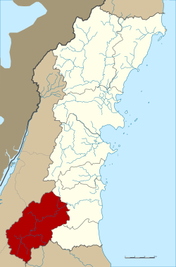
Amphoe Phato
|
Phato พะโต๊ะ |
|
|---|---|
| Province: | Chumphon |
| Surface: | 928.0 km² |
| Residents: | 23,414 (2012) |
| Population density : | 23.9 U / km² |
| ZIP : | 86180 |
| Geocode : | 8606 |
| map | |

|
|
Amphoe Phato ( Thai : อำเภอ พะโต๊ะ , pronunciation: [pʰáʔtòʔ] ) is a district ( Amphoe - administrative district) in the south of Chumphon Province . Chumphon Province is located in the southern region of Thailand .
geography
Amphoe Phato is bounded by the following Amphoe (clockwise from the east): Amphoe Lang Suan and Amphoe Lamae of Chumphon Province, Amphoe Tha Chana and Chaiya of Surat Thani Province and Amphoe Kapoe , Amphoe Mueang Ranong and Amphoe La-un of the Province Ranong .
The Kuan Mae Yai Mon Game Reserve is in the southwest of the county . One of the main attractions here is the Heo Lom waterfall. The terrain is mainly mountainous with a few small rivers that are popular for rafting .
history
Phato was originally a district under the administration of the City ( Mueang ) Lang Suan, but in 1932 it became a district of Chumphon Province. In 1938 Phato was again devalued to a small district ( King Amphoe ) . On June 19, 1991 Phato received full amphoe status.
Symbols
The district's motto is: Green hills, rafting, beautiful waterfalls, famous for its fruits. (Thai: ภูเขา เขียว เที่ยว ล่อง แพ แล หมอก ปก น้ำตก งาม ลือนาม ผล ไม้ )
administration
Provincial Administration
Amphoe Lamae consists of four sub-districts ( tambon ) , which are further divided into 43 villages ( muban ) .
|
Local administration
There is a small town ( Thesaban Tambon ) in the district:
- Phato ( เทศบาล ตำบล พะโต๊ะ ) consists of parts of the Tambon Phato,
There are also four "Tambon Administration Organizations" (TAO, องค์การ บริหาร ส่วน ตำบล ) for the Tambon or the parts of Tambon in the county that do not belong to any town.
Individual evidence
- ↑ ประกาศ สำนัก นายกรัฐมนตรี เรื่อง ยุบ รวม อำเภอ และ ยุบ อำเภอ ลง เป็น กิ่ง อำเภอ . In: Royal Gazette . 55, No. 0 ง , August 29, 1938, p. 1840.
- ↑ พระราชกฤษฎีกา ตั้ง อำเภอ ทุ่งตะโก อำเภอ พะโต๊ะ อำเภอ เขา ค้อ อำเภอ น้ำ หนาว อำเภอ วัง จันทร์ อำเภอ นาด้วง อำเภอ เต่า ง อย อำเภอ สิงห สิงห นคร อำเภอ พระ สมุทร เจดีย์ และ อำเภอ ลำดวน พ.ศ. ๒๕๓๔ . In: Royal Gazette . 108, No. 107 ก Special ( ฉบับ พิเศษ ), June 19, 1991, pp. 29–33.
- ↑ Population statistics 2012 . Department of Provincial Administration. Retrieved July 7, 2014.
Web links
Coordinates: 9 ° 48 ' N , 98 ° 47' E

