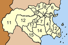
Amphoe Mueang Chumphon
|
Mueang Chumphon เมือง ชุมพร |
|
|---|---|
| Province: | Chumphon |
| Surface: | 748.39 km² |
| Residents: | 144,968 (2012) |
| Population density : | 189.4 U / km² |
| ZIP : | 86000, 86190, 86100, 86120 |
| Geocode : | 8601 |
| map | |

|
|
Amphoe Mueang Chumphon ( Thai อำเภอ เมือง ชุมพร ) is a district ( Amphoe - Administrative District) in Chumphon Province . Chumphon Province is located in the southern region of Thailand .
Chumphon is the capital of Mueang Chumphon County and is also the capital of Chumphon Province.
geography
Neighboring districts are (from south clockwise): Amphoe Sawi Chumphon province, Amphoe Kra Buri of Ranong province and Amphoe Tha Sae and Pathio turn in Chumphon province.
administration
Provincial Administration
Amphoe Mueang Chumphon is divided into 17 communities ( tambon ) , which are further divided into 165 villages ( muban ) .
| No. | Surname | Thai | Muban | Pop. | No. | Surname | Thai | Muban | Pop. | |
|---|---|---|---|---|---|---|---|---|---|---|
| 1. | Tha Taphao | ท่า ตะเภา | - | 11,456 | 10. | Wang Phai | วังไผ่ | 13 | 11,658 | |
| 2. | Pak Nam | ปากน้ำ | 10 | 13,554 | 11. | Wang Mai | วัง ใหม่ | 9 | 8,797 | |
| 3. | Tha Yang | ท่ายาง | 11 | 9,978 | 12. | Ban Na | บ้านนา | 13 | 8,837 | |
| 4th | Bang Mak | บาง หมาก | 13 | 13,414 | 13. | Khun Krathing | ขุน กระทิง | 8th | 4.106 | |
| 5. | Well Thung | นา ทุ่ง | 10 | 11.305 | 14th | Thung Kha | ทุ่ง คา | 11 | 7,013 | |
| 6th | Na Cha-ang | นา ชะ อัง | 9 | 6,385 | 15th | Wisai Nuea | วิสัย เหนือ | 12 | 6,285 | |
| 7th | Tak Daet | ตาก แดด | 9 | 10,979 | 16. | Has Sai Ri | หาด ทราย รี | 7th | 4,067 | |
| 8th. | Bang Luek | บาง ลึก | 12 | 8,424 | 17th | Tham Sing | ถ้ำ สิงห์ | 6th | 3,281 | |
| 9. | Has Phan Krai | หาด พัน ไกร | 12 | 5,429 |
Local administration
Chumphon ( เทศบาล เมือง ชุมพร ) is a city ( Thesaban Mueang ) in the district, it includes the entire Tambon Tha Taphao and parts of the Tambon Bang Mak, Na Thung, Tak Daet, Khun Krathing and Wang Phai.
There are still nine small towns ( Thesaban Tambon ) :
- Wang Phai ( เทศบาล ตำบล วังไผ่ ) consists of parts of the Tambon Wang Phai.
- Bang Luek ( เทศบาล ตำบล บาง ลึก ) consists of the entire tambon Bang Luek.
- Na Cha-ang ( เทศบาล ตำบล นา ชะ อัง ) consists of the entire tambon Na Cha-ang.
- Khun Krathing ( เทศบาล ตำบล ขุน กระทิง ) consists of parts of the Tambon Khun Krathing.
- Bang Mak ( เทศบาล ตำบล บาง หมาก ) consists of parts of the Tambon Bang Mak.
- Paknam Chumphon ( เทศบาล ตำบล ปากน้ำ ชุมพล ) consists of parts of the Tambon Paknam.
- Tha Yang ( เทศบาล ตำบล ท่ายาง ) consists of the entire Tambon Tha Yang.
- Hat Sai Ri ( เทศบาล ตำบล หาด ทราย รี ) consists of the entire tambon Hat Sai Ri.
- Wang Mai ( เทศบาล ตำบล วัง ใหม่ ) consists of the entire tambon Wang Mai.
There are also nine “tambon administrative organizations” (TAO, องค์การ บริหาร ส่วน ตำบล ) for the tambon or the parts of tambon in the county that do not belong to any town.
Individual evidence
- ↑ Population statistics 2012 . Department of Provincial Administration. Retrieved July 7, 2014.
Web links
Coordinates: 10 ° 30 ' N , 99 ° 11' E

