Amphoe Sawi
|
Sawi สวี |
|
|---|---|
| Province: | Chumphon |
| Surface: | 898.0 km² |
| Residents: | 71,624 (2012) |
| Population density : | 77.2 U / km² |
| ZIP : | 86130 |
| Geocode : | 8607 |
| map | |

|
|
Sawi District ( Thai : อำเภอ สวี ) is a district ( Amphoe - administrative district) of Chumphon province . Chumphon Province is located in the southern region of Thailand .
geography
Amphoe Sawi is bounded by the following Amphoe (clockwise from the south): Amphoe Thung Tako and Amphoe Lang Suan of Chumphon Province, Amphoe La-un and Amphoe Kra Buri of Ranong Province and Amphoe Mueang Chumphon again in Chumphon. To the east lies the Gulf of Thailand .
history
The history of Sawi goes back to the city ( Mueang ) Sawi, which was on the banks of the Sawi River. On April 16, 1897, the first county administration in "Village 5" of Tambon Na Pho was opened. After the administration had been relocated several times, it is now in "Village 4" of Tambon Sawi, where it was opened on October 1, 2001.
administration
Provincial Administration
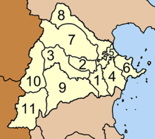
Amphoe Lamae consists of eleven sub-districts ( tambon ) , which are further divided into 114 villages ( muban ) .
|
Local administration
There are two small towns ( Thesaban Tambon ) in the district:
- Na Pho ( เทศบาล ตำบล นา โพธิ์ ) consists of parts of the Tambon Na Pho.
- Na Pho Phatthana ( เทศบาล ตำบล นา โพธิ์ พัฒนา ) consists of further parts of the Tambon Na Pho.
There are also nine “tambon administrative organizations” (TAO, องค์การ บริหาร ส่วน ตำบล ) for the tambon in the district that do not belong to any city.
Individual evidence
- ↑ Population statistics 2012 . Department of Provincial Administration. Retrieved July 7, 2014.
Web links
Coordinates: 10 ° 15 ' N , 99 ° 6' E

