Amphoe Kra Buri
|
Kra Buri กระบุรี |
|
|---|---|
| Province: | Ranong |
| Surface: | 783.0 km² |
| Residents: | 46,075 (2012) |
| Population density : | 57.2 U / km² |
| ZIP : | 85110 |
| Geocode : | 8504 |
| map | |

|
|
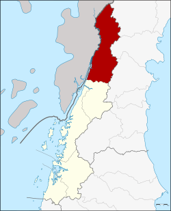
Amphoe Kra Buri ( Thai : อำเภอ กระบุรี ) is a district ( amphoe - administrative district) in the north of Ranong Province . Ranong Province is located in the southern region of Thailand .
geography
Kra Buri District is bounded by the following Amphoe (seen from the northeast clockwise from): Amphoe Tha Sae , Mueang Chumphon and Sawi of Chumphon province and La-un District of Ranong province. To the west lies the Tanintharyi Division of Myanmar .
The Maenam Kraburi (Kraburi River) is an important water resource. Its large estuary is protected as a wetland under the Ramsar Convention . The eastern bank of the estuary is part of the Lam-Nam-Kraburi National Park (Thai: อุทยานแห่งชาติ ลำน้ำ กระบุรี ).
history
Mueang Tra (also: Kra) was founded during the Ayutthaya period as a "4th class city" under the administration of Chumphon Province . Its first governor was a Mr. Kaew, a cousin of the governor of Nakhon Si Thammarat province , he was later promoted to Phra Kaew Korop (พระ แก้ว โกรพ ). Mueang Tra was a border town of the Ayutthaya Kingdom. The old city was in what is now Tambon Pak Chan. In 1884, Phra Atsadongkhata Thisaraksa (Thai:พระ อัษฎ ง ค ต ทิศ รักษา ) moved the administration, and with it the city center, to Tambon Nam Chuetfor strategic reasons.
Two major battles against Burmese invaders took place near Mueang Tra, once in 1764 during the reign of King Ekathat and once in 1786 in the Rattanakosin period during the reign of King Phra Phutthayotfa Chulalok ( Rama I ) . During World War II, Tra was the location of the western division of the Japanese Army, which built a railway line from Kraburi via La Un to Mueang Ranong. Around 1896 Kra Buri was devalued to a county in Ranong Province.
administration
Provincial Administration
Amphoe Kra Buri is divided into seven communities ( Tambon ) , which are further subdivided into 60 villages ( Muban ) .
|
Local administration
There are two small towns ( Thesaban Tambon ) in the county:
- Nam Chuet ( เทศบาล ตำบล น้ำ จืด ) consists of parts of the Tambon Nam Chuet,
- Choporo ( เทศบาล ตำบล จ.ป.ร. ) consists of the entire tambon Choporo.
There are also six “Tambon Administrative Organizations” (TAO, องค์การ บริหาร ส่วน ตำบล - administrative organizations) in the district.
Individual evidence
- ↑ UNESCO Biosphere Reserve Directory: Ranong (in English)
- ↑ Population statistics 2012 . Department of Provincial Administration. Retrieved April 24, 2014.
Web links
- More information on Amphoe Kra Buri from amphoe.com (in Thai). Archived from the original on September 18, 2010 ; Retrieved July 25, 2015 .
- Information on Lam Nam Kraburi National Park from dnp.go.th (in English)
Coordinates: 10 ° 26 ' N , 98 ° 47' E

