Amphoe Mueang Ranong
|
Mueang Ranong เมือง ระนอง |
|
|---|---|
| Province: | Ranong |
| Surface: | 713.7 km² |
| Residents: | 90,270 (2012) |
| Population density : | 126.9 U / km² |
| ZIP : | 85000, 85130 |
| Geocode : | 8501 |
| map | |

|
|
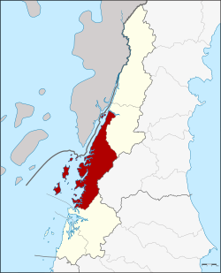
Amphoe Mueang Ranong ( Thai : อำเภอ เมือง ระนอง ) is a district ( amphoe - administrative district) in Ranong Province . Ranong Province is located in the southern region of Thailand .
Ranong is also the name of a city in the county.
geography
Ranong Province is located in southern Thailand on the Kra Isthmus .
Neighboring districts are (from north clockwise): La-un District of the province of Ranong, Phato District of Chumphon province and Kapoe District again in Ranong. To the west, across the mouth of the Maenam Kraburi (Kraburi River), lies the Tanintharyi Division of Myanmar .
administration
Provincial Administration
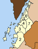
Amphoe Mueang Ranong is divided into nine communities ( tambon ) , which are further divided into 39 villages ( muban ) .
|
Local administration
There are two towns ( Thesaban Mueang ) in the county:
- Ranong ( เทศบาล เมือง ระนอง ) includes the entire tambon Khao Niwet.
- Bang Rin ( เทศบาล เมือง บาง ริ้น ) includes the entire Tambon Bang Rin.
There are also five small towns ( Thesaban Tambon ) :
- Ngao ( เทศบาล ตำบล ห งาว ) includes the entire Tambon Ngao.
- Pak Nam ( เทศบาล ตำบล ปากน้ำ ) comprises parts of the Tambon Pak Nam.
- Ratchakrut ( เทศบาล ตำบล ราช กรูด ) comprises the entire tambon Ratchakrut.
- Pak Nam Tha Ruea ( เทศบาล ตำบล ปากน้ำ ท่าเรือ ) includes other parts of the Tambon Pak Nam.
- Bang Non ( เทศบาล ตำบล บาง นอน ) comprises the entire tambon Bang Non.
There are also four "Tambon Administration Organizations" (TAO, องค์การ บริหาร ส่วน ตำบล ) for the Tambon or the parts of Tambon in the county that do not belong to any town.
Individual evidence
- ↑ Population statistics 2012 . Department of Provincial Administration. Retrieved April 24, 2014.
Web links
- More information on Amphoe Mueang Ranong from amphoe.com (in Thai; last accessed December 1, 2015)
Coordinates: 9 ° 58 ' N , 98 ° 38' E


