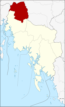
Plai Phraya district
|
Plai Phraya ปลายพระยา |
|
|---|---|
| Province: | Krabi |
| Surface: | 433.4 km² |
| Residents: | 37,745 (2012) |
| Population density : | 81.8 U / km² |
| ZIP : | 81160 |
| Geocode : | 8106 |
| map | |

|
|
Plai Phraya District ( Thai : อำเภอ ปลายพระยา ) is a district ( Amphoe - administrative district) of the province of Krabi . Krabi Province is located in the southern region of Thailand .
geography
Neighboring districts are (from north clockwise): Amphoe Phanom , Phrasaeng , Chai Buri the province of Surat Thani , Amphoe Khao Phanom and Ao Luek , Krabi and Amphoe Thap Put the province of Phang Nga .
history
The district of Plai Phraya was initially set up as a subdistrict ( King Amphoe ) on June 15, 1973 by separating the three tambon Plai Phraya, Khao Khen and Khao To from the Ao Luek district . It got its full amphoe status on April 12, 1977.
Nature reserve
The " Khlong Phraya Wildlife Sanctuary" is on the border with Surat Thani.
administration
Provincial Administration
The Amphoe Plai Phraya is divided into four communities ( tambon ) , which in turn are divided into 33 village communities ( muban ) .
|
Local administration
Plai Phraya ( เทศบาล ตำบล ปลายพระยา ) is a small town ( Thesaban Tambon ) in the district, it includes parts of the tambon Plai Phraya.
There are also four "Tambon Administration Organizations" (TAO, องค์การ บริหาร ส่วน ตำบล ) for the Tambon or the parts of Tambon in the county that do not belong to any town.
Individual evidence
- ↑ ประกาศ กระทรวง มหาดไทย เรื่อง แบ่ง ท้องที่ อำเภอ อ่าวลึก จังหวัด กระบี่ ตั้ง เป็น กิ่ง อำเภอ ปลายพระยา Royal Gazette, Vol. 90, Issue 67 ง of June 12, 1973, p. 1840 (in Thai)
- ↑ พระราชกฤษฎีกา ตั้ง อำเภอ ปลายพระยา อำเภอ ห้วยเม็ก อำเภอ ละแม อำเภอ แม่จริม อำเภอ หนองกี่ อำเภอ โคกปีบ อำเภอ เกาะพะงัน อำเภอ สนม อำเภอ โซ่พิสัย อำเภอ โนนสะอาด และ อำเภอ นาจะหลวย พ.ศ. ๒๕๒๐ Royal Gazette, Vol. 94, Issue 31 ก April 12, 1977, pp. 326–330 (in Thai)
- ↑ Population statistics 2012 . Department of Provincial Administration. Retrieved July 7, 2014.
Web links
Coordinates: 8 ° 32 ' N , 98 ° 52' E

