Amphoe Khao Phanom
|
Khao Phanom เขาพนม |
|
|---|---|
| Province: | Krabi |
| Surface: | 788.5 km² |
| Residents: | 52,732 (2012) |
| Population density : | 58.3 U / km² |
| ZIP : | 81140, 80240 |
| Geocode : | 8102 |
| map | |

|
|
Khao Phanom District ( Thai : อำเภอ เขาพนม ) is a district ( Amphoe - administrative district) of the province of Krabi . Krabi Province is located in the southern region of Thailand .
geography
Neighboring districts (clockwise from north): Chai Buri and Phrasaeng district of Surat Thani province , Thung Yai district of Nakhon Si Thammarat province and Lam Thap district , Khlong Thom , Nuea Khlong , Mueang Krabi , Ao Luek and Plai Phraya district of the province Krabi.
National park
The Khao Phanom Bencha National Park protects the forest around the Khao Phanom Bencha, the highest point in Krabi Province at 1,397 meters.
history
On December 1, 1967, Khao Phanom was initially set up as a sub-district ( King Amphoe ) by amalgamating the Tambon Khao Phanom, Khao Din, two villages of Khok Yang of Amphoe Mueang Krabi and Tambon Sin Pun of Amphoe Khlong Thom . It was granted full Amphoe status on June 29, 1973.
administration
Provincial Administration
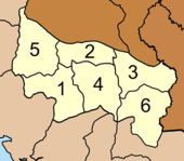
Amphoe Khao Phanom is divided into six communities ( tambon ) , which in turn are divided into 54 village communities ( muban ) .
|
Local administration
Khao Phanom ( เทศบาล ตำบล เขาพนม ) is a small town ( Thesaban Tambon ) in the district, which includes parts of the Tambon Khao Phanom.
There are also six “tambon administrative organizations” (TAO, องค์การ บริหาร ส่วน ตำบล ) for the tambon or the parts of tambon in the district that do not belong to any city.
Individual evidence
- ↑ ประกาศ กระทรวง มหาดไทย เรื่อง แบ่ง ท้องที่ ตั้ง เป็น กิ่ง อำเภอ Royal Gazette, Vol. 84, Issue 125 ง of December 26, 1967, p. 3326 (in Thai)
- ↑ พระราชกฤษฎีกา ตั้ง อำเภอ เขาพนม อำเภอ สนามชัยเขต อำเภอ แม่อาย อำเภอ ขามสะแกแสง อำเภอ เก้าเลี้ยว อำเภอ โพธิ์ประทับช้าง อำเภอ หนองพอก อำเภอ ละอุ่น อำเภอ ทุ่งหว้า และ อำเภอ ศรีธาตุ พ.ศ. ๒๕๑๖ Royal Gazette, Vol. 90, Ed. 75 ก ฉบับ พิเศษ (special) from June 28, 1973, pp. 32–36 (in Thai)
- ↑ Population statistics 2012 . Department of Provincial Administration. Retrieved July 7, 2014.
Web links
- More details on Amphoe Khao Phanom from amphoe.com (in Thai)
- Information on Khao Phanom Bencha National Park from dnp.go.th (in English)
Coordinates: 8 ° 16 ' N , 99 ° 3' E

