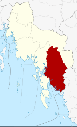
Amphoe Khlong Thom
|
Khlong Thom คลองท่อม |
|
|---|---|
| Province: | Krabi |
| Surface: | 1042.53 km² |
| Residents: | 74,265 (2012) |
| Population density : | 61.1 U / km² |
| ZIP : | 81120, 81170 |
| Geocode : | 8104 |
| map | |

|
|
Khlong Thom District ( Thai : อำเภอ คลองท่อม ) is a district ( Amphoe - administrative district) of the province of Krabi . Krabi Province is located in the southern region of Thailand .
geography
Neighboring districts (clockwise from west): the Amphoe Ko Lanta , Nuea Khlong , Khao Phanom and Lam Thap of Krabi Province and the Amphoe Wang Wiset and Sikao of Trang Province . To the southwest lies the Andaman Sea .
history
In 1917 the district was renamed from Khlong Phon ( คลอง พล ) to Khlong Thom.
administration
Provincial Administration
Amphoe Khlong Thom is divided into five subdistricts ( tambon ) , which are further subdivided into 65 village communities ( muban ) .
|
Local administration
There are four small towns ( Thesaban Tambon ) in the county:
- Khlong Thom Tai ( เทศบาล ตำบล คลองท่อม ใต้ ) consists of parts of the Tambon Khlong Thom Tai,
- Khlong Phon ( เทศบาล ตำบล คลอง พ น ) consists of parts of the Tambon Khlong Phon.
- Khlong Phon Phatthana ( เทศบาล ตำบล คลอง พ น พัฒนา ) consists of further parts of the Tambon Khlong Phon,
- Sai Khao ( เทศบาล ตำบล ทรายขาว ) consists of the entire tambon Sai Khao.
There are also five “tambon administration organizations” (TAO, องค์การ บริหาร ส่วน ตำบล ) for the tambon or the parts of tambon in the county that do not belong to any town.
Individual evidence
- ↑ ประกาศ กระทรวง มหาดไทย เรื่อง เปลี่ยน ชื่อ อำเภอ . In: Royal Gazette . 34, No. 0 ก , April 29, 1917, pp. 40-68.
- ↑ Population statistics 2012 . Department of Provincial Administration. Retrieved July 7, 2014.
Web links
Coordinates: 7 ° 57 ' N , 99 ° 9' E

