
Ko Lanta
| Ko Lanta | ||
|---|---|---|
 |
||
| Waters | Strait of Malacca | |
| Geographical location | 7 ° 36 ′ N , 99 ° 4 ′ E | |
|
||
| Number of islands | 2 | |
| Main island | Ko Lanta Yai | |
| Residents | 20,948 (2005) | |
 |
||

Ko Lanta ( Thai : เกาะลันตา ) is a twin island in the southwest of the southern region of Thailand .
Ko Lanta is also the headquarters of the administration of Ko Lanta County ( Amphoe ) in Krabi Province .
geography
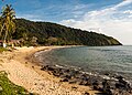
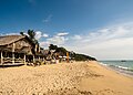
Ko Lanta is located at the junction of the Strait of Malacca into the Andaman Sea . The double island is divided into "Lanta Yai" ( เกาะลันตา ใหญ่ , Big Lanta , with an extension of about 27 km in length and 12-15 km in width) in the south and "Lanta Noi" ( เกาะลันตา น้อย , Little Lanta ) in the north, which are separated by a natural sea waterway about one kilometer wide (ferry connection). While Lanta Noi is almost uninhabited, there are numerous places and an extensive tourist infrastructure on Lanta Yai. The two Lanta Islands are part of the "Mu Ko Lanta National Park" ( อุทยานแห่งชาติ หมู่ เกาะลันตา ).
Demographics
Ko Lanta Yai has about 20,000 inhabitants, mostly Muslim fishermen. Around 4% of the population are merchants of Chinese descent, around 1% belong to the Moken ethnic group , who are often referred to as "sea gypsies". In addition to their main livelihood, fishing, the residents also breed cattle, cultivate rice and cultivate coconut and rubber plantations.
climate
The island of Ko Lanta is located in the tropical climate zone and has year-round temperatures between 23 ° C and 35 ° C. The weather is mainly determined by two seasons. The dry and hot season begins in December and lasts until April. Especially in the months of February to April it can get very hot and dry on Ko Lanta with up to 35 ° C. During the months of May to the beginning of December, the rainy season prevails in the region, which peaks in September and October. Heavy rains occur frequently throughout the months and the weather is very changeable. Most of the sea is very choppy, and strong winds often lead to high waves along the coast. The annual rainfall on Ko Lanta is 2569 mm. The sea water temperatures are around 27–29 ° C all year round.
reachability
The closest airport is Krabi . From there and from Phuket and Trang Airports there are minibuses. Passenger ferries run (sometimes depending on the season) to Krabi , Ko Phi Phi and across the Trang Islands to Ko Li Pe . The northern part of the island can be reached by car ferry Lanta Noi via a junction of expressway 4 and via a road bridge. With the new construction of the road bridge, a previous ferry connection became obsolete.
gallery

Ko Lanta Thailand beach
Ko Lanta Thailand booth
Beach in Ko Lanta

Beach house in Ko Lanta


.jpg)