
Yala (province)
| Yala | |
|---|---|
| ยะลา | |

|
|
| statistics | |
| Capital: | Yala |
| Telephone code: | 073 |
| Surface: |
4,521.1 km² 48. |
| Residents: |
480,334 (2008) 55. |
| Population density : | 106 E / km² 41. |
| ISO 3166-2 : | |
| Governor : | |
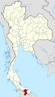
| map | |
  |
|
Yala ( Thai ยะลา , Malay Jolor ) is a province ( Changwat ) in southern Thailand . The capital of the province is also called Yala .
etymology
The name Yala is the Thai transliteration of Jala ( Jawi :جال), its original Malay name means 'network'. The province is also called Jolor in Patani Malay (Jawi:جولور) called.
geography
Yala is located in the extreme south of Thailand on the Malay Peninsula on the border with Malaysia . Yala is the only province in the south of the country that has no coastline to the Indian or Pacific Ocean .
The highest point of the Sankalakhiri Mountains (northern Titiwangsa Mountains), 1533 meters high, lies on the Thai-Malaysian border between Yala and Perak .
| Adjacent provinces and areas: | |
|---|---|
| north | Pattani and Songkhla |
| east | Narathiwat |
| south | National border with Malaysia |
| west | National border with Malaysia |
Important cities
- Betong , the southernmost city of Thailand
climate
The climate is tropical - monsoonal , and due to its location close to the equator, heavy rainfall can occur all year round. The maximum temperature in 2008 was 36.8 ° C, the lowest temperature was measured at 20.6 ° C. On 164 rainy days in the same year, 2181.0 mm of precipitation fell.
Economy and Importance
General
Yala is one of the richest provinces in the south, mainly because of the high-yield rubber plantations .
The "Gross Provincial Product" ( GDP ) of the province in 2008 was 42,630 million Baht . The minimum wage in the province is 172 baht per day (around € 4).
Data
The table below shows the share of the economic sectors in the gross provincial product in percent.
| Industry | 2006 | 2007 | 2008 |
|---|---|---|---|
| Agriculture | 47.3 | 47.3 | 48.9 |
| Industry | 6.6 | 6.7 | 6.0 |
| Other | 46.1 | 46.0 | 45.1 |
All figures in%
Land use
The following land use is documented for the province:
- Forest area : 948,710 Rai (592.9 km²), 33.6% of the total area
- Agricultural area : 758,512 rai (474.1 km²), 26.8% of the total area
- Unclassified area : 1,118,452 rai (699.0 km²), 39.6% of the total area
Local products
Local products under the One Tambon One Product program are in Yala:
- Kluai-Hin bananas: a variety similar to Kluai-Nam-Wa bananas, which when cooked or glazed have a nutty taste
- Betong-style soy sauce : a sauce made from soy that is specially made
- Shogun oranges: the leading product in Yala fruit growing, similar to the green sweet orange with a softer, tastier flesh
Dams
- The Bang Lang Dam is located about 60 km from the provincial capital, it is fed by the Maenam Pattani (Pattani River) . The reservoir covers an area of about 50 km² and has many smaller islands.
history
In early times, the capital of the region in what is now southern Thailand was in Pattani , which was the capital of a kingdom of the same name . However, the kingdom had to pay tribute to the Thai kingdom of Sukhothai and later to its successor Ayutthaya . After the collapse of Ayutthaya in 1767, Pattani initially received full independence, but under the rule of King Phra Phutthayotfa Chulalok (Rama I) it came back under Siam's control.
After the British had established themselves on the Malay Peninsula and created a new order, Pattani - and thus today's Yala - became part of the Kingdom of Siam in 1909. Together with Narathiwat, Yala was originally part of the Pattani Province, but was separated in 1933 and made an independent province. See also : History of Thailand
Problems
After long years of calm, a separatist movement has been active in the south since 2004 , carrying out bomb attacks and killing opponents, particularly in the provinces of Narathiwat , Pattani and Yala. Since January 2004, more than 800 people have died in this way. The last attack was on October 25, 2011 in the center of Yala, killing 3 people and sustaining 44 other people, some of them life-threatening. Two of the people who died were militant rebels who transported the explosive device on the scooter. A total of 21 explosive devices were positioned throughout Yala, 16 of which exploded and five more could be defused. On January 24, 2018, three people were killed in a bomb attack in Yala market.
population
Yala is one of the four provinces in which it is not Buddhists (31.0% in the 2000 census) but Muslims (68.9%) who make up the majority of the population. Most of them are of Malay origin (66.1% are Malay ), they speak a Malay dialect, Pattani-Malay ( Thai ยา วี - Yawi ). 3% of the population speak Chinese as their first language. There are also members of the Semang here who speak the Kensiu language.
coat of arms
| The coat of arms of the province of Yala shows a miner with simple tools such as a hoe and basket. Yala was originally a mining town where tin and tungsten were mined.
The local tree is the red ashok tree ( Saraca declinata ), the local flower is the balata tree (also horse meatwood, Mimusops elengi ). The motto of Yala Province is simply: "The southernmost province of Thailand, great to look at and a borderland." |
Administrative units
Provincial Administration
Yala is divided into 8 Amphoe (districts), which in turn are divided into 56 municipalities ( Tambon ) and 341 districts ( Muban ) .
|

Local administration
A provincial administrative organization ( บริหาร ส่วน จังหวัด , อบ จ for short , Ongkan Borihan suan Changwat ; English Provincial Administrative Organization , PAO) exists for the entire area of the province .
In the province there is one big city ( เทศบาล นคร - Thesaban Nakhon ): Yala ( เทศบาล นคร ยะลา ) and two cities ( เทศบาล เมือง - Thesaban Mueang ): Sateng Nok ( เทศบาล เมือง สะ เต ง นอก ) and Betong ( เทศบาล เมือง เบตง ). There are also 7 small towns ( เทศบาล ตำบล - Thesaban Tambon ).
Attractions
( See entry in Yala )
- Krachang Cave - about 50 km from Yala, with a flowing body of water and stalactites
- National parks:
- Bang Lang National Park - 60 km from Yala towards Betong; very beautifully located in the middle of a mountain landscape with a nine-tier waterfall that falls from steep cliffs.
literature
- Thailand in Figures 2011 . 13th edition. Alpha Research, Nonthaburi 2011, ISBN 978-616752603-4 .
Web links
- General map of the province (names in Thai and English) accessed on November 9, 2013
- Tourist information about Yala Province - Tourism Authority of Thailand TAT website
- Yala Province website (in Thai)
Individual evidence
- ↑ Gunong Ulu Titi Basah: Thailand
- ↑ a b c Thailand in Figures (2011), p. 407
- ↑ a b Bangkok Post ( memento from July 23, 2012 in the web archive archive.today ) (English, accessed October 28, 2011)
- ^ The Nation (accessed October 25, 2011)
- ↑ web.nso.go.th (PDF) - Yala Province of the Census 2000
- ↑ Shuichi Nagata: Subgroup 'names' of the Sakai (Thailand) and the Semang (malaysia): a literature survey . In: Anthropological Science , Volume 114, 2005, pp. 45-57
- ↑ Department of Provincial Administration : As of 2012 (in Thai)
North : Chiang Mai | Chiang Rai | Kamphaeng Phet | Lampang | Lamphun | Mae Hong Son | Nakhon Sawan | Nan | Phayao | Phetchabun | Phichit | Phitsanulok | Phrae | Sukhothai | Tak | Uthai Thani | Uttaradit
Northeast : Amnat Charoen | Bueng Kan | Buri Ram | Chaiyaphum | Kalasin | Khon Kaen | Loei | Maha Sarakham | Mukdahan | Nakhon Phanom | Nakhon Ratchasima | Nong Bua Lam Phu | Nong Khai | Roi Et | Sakon Nakhon | Si Sa Ket | Surin | Ubon Ratchathani | Udon Thani | Yasothon
Central : Ang Thong | Ayutthaya | Bangkok | Chachoengsao | Chai Nat | Chanthaburi | Chon Buri | Kanchanaburi | Lop Buri | Nakhon Nayok | Nakhon Pathom | Nonthaburi | Pathum Thani | Phetchaburi | Prachin Buri | Prachuap Khiri Khan | Ratchaburi | Rayong | Sa Kaeo | Samut Prakan | Samut Sakhon | Samut Songkhram | Saraburi | Sing Buri | Suphan Buri | Stepped
South : Chumphon | Krabi | Nakhon Si Thammarat | Narathiwat | Pattani | Phang-nga | Phatthalung | Phuket | Ranong | Satun | Songkhla | Surat Thani | Trang | Yala
Coordinates: 6 ° 32 ' N , 101 ° 17' E