
Samut Songkhram (Province)
| Samut Songkhram | |
|---|---|
| สมุทรสงคราม | |

|
|
| statistics | |
| Capital: | Samut Songkhram |
| Telephone code: | 034 |
| Surface: |
416.7 km² 76. |
| Residents: |
193,647 (2009) 75. |
| Population density : | 462 E / km² 9. |
| ISO 3166-2 : | |
| Governor : | |
| map | |
  |
|
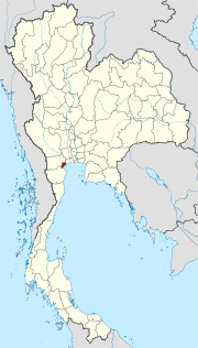
Samut Songkhram ( Thai : สมุทรสงคราม ) is a province ( Changwat ) in the central region of Thailand . The capital of Samut Songkhram Province is also called Samut Songkhram . The province lies on the coast to the Gulf of Thailand .
geography
Samut Songkhram is located about 70 kilometers southwest of Bangkok at the mouth of the Mae Nam Mae Klong (Mae Klong River) , which flows into the Gulf of Thailand. Many canals ( khlongs ) provide water for the agricultural areas in the province.
There are numerous salt lakes on the coast for the extraction of sea salt .
Samut Songkhram is the smallest province in Thailand in terms of area, less than half the size of the German capital Berlin .
| Adjacent provinces and areas: | |
|---|---|
| north | Samut Sakhon |
| east | Coast to the Gulf of Thailand |
| south | Phetchaburi |
| west | Ratchaburi |
As early as 1840 there were fields and plantations for bananas, coconuts and tamarinds here. The area was poorly cultivated.
climate
The climate is tropical - monsoonal .
Economy and Importance
In 2008, the "Gross Provincial Product" (was GDP ) of the province of 16,841 million baht .
Data
The table below shows the share of the economic sectors in the gross provincial product in percent:
| Industry | 2006 | 2007 | 2008 |
|---|---|---|---|
| Agriculture | 8.0 | 7.7 | 7.8 |
| Industry | 21.0 | 23.1 | 24.6 |
| Other | 71.0 | 69.2 | 67.6 |
Land use
| Industry | Percentage ownership % |
|---|---|
| Agriculture | 30.1 |
| Woodland | 4.9 |
| Others | 65.0 |
In addition to the important salt production, there are also farms for lobsters . The agriculture mainly produces fruits guava (in Thailand Luhk Farang called), grapes , lychee , pomelo , mangoes and coconuts .
traffic
Airport
- Bangkok International Airport (IATA code BKK)
history
During the Ayutthaya period , Samut Songkhram Suan Nork (Thai: สวน นอก , something like "outside garden") was called and belonged to Ratchaburi . Under King Taksin , the province was spun off from Ratchaburi and renamed Mae Klong.
During the reign of King Rama I (r. 1782-1809) a comprehensive tax system was introduced, including for alcohol. Samut Songkhram was administered together Ratchaburi and Kanchanaburi .
In Samut Songkhram is the birthplace of King Phra Phutthaloetla ( Rama II. ) And his mother Queen Amarindra (1737-1826), his son King Nang Klao ( Rama III. , Ruled 1824 to 1851) left at the mouth of the Mae Klong build a fortress (Phikhat Khasuk).
Attractions

- Museum of King Rama II - in Amphoe Amphawa there are five houses that are located at the birthplace of the king
- Talat Amphawa - floating market held on the khlongs.
- "Railway market" on Mae Klong ( Thai ตลาด ร่ม หุบ , RTGS Talat Rom Hup , literally "folding umbrella market", in tourist parlance Railway Market ) - market on the tracks of the Thonburi – Samut Songkhram railway line , whose stalls are quickly cleared away when the Train is coming.
coat of arms
The coat of arms of Samut Songkhram province shows a drum floating on a watercourse. This is reminiscent of the Mae Nam Mae Klong River ( Klong is the drum in Thai). Coconut trees, one of the main products of the province, can be seen on both banks of the river .
The local tree is Casuarina equisetifolia .
The motto of Samut Songkhram Province is:
The land of the Hoi Lot, a species of oyster ,
Lychee is the best fruit here for the gourmets,
The memorial to King Rama II is in this city,
Luang Pho Ban Laem and the Mae Klong are interesting places.
Administrative units
The province is divided into 3 administrative districts ( Amphoe ) , which in turn are divided into 38 municipalities ( Tambon ) and further into 284 village communities ( Muban ) .
There is one city ( เทศบาล เมือง - Thesaban Mueang) in the province : Samut Songkhram ( เทศบาล เมือง สมุทรสงคราม ).
There are also four small towns ( เทศบาล ตำบล - Thesaban Tambon).
|

literature
- Barend Jan Terwiel : Trough Travelers' Eyes: an approach to nineteenth century Thai history . Bangkok: Duang Kamol 1989. ISBN 974-210-455-7 .
- Thailand in Figures . 13. A. Nonthaburi: Alpha Research 2011. ISBN 978-616752603-4 .
Web links
- Information about the province Samut Songkhram - side of the Tourism Authority of Thailand (English)
- Overview map of the province (names in Thai and English) [last accessed on November 7, 2013]
Individual evidence
- ↑ Terwiel (1989), p. 70
- ↑ a b Thailand in Figures (2011), p. 307.
- ↑ Terwiel (1989), p. 72
- ↑ Department of Provincial Administration : As of 2012 (in Thai)
North : Chiang Mai | Chiang Rai | Kamphaeng Phet | Lampang | Lamphun | Mae Hong Son | Nakhon Sawan | Nan | Phayao | Phetchabun | Phichit | Phitsanulok | Phrae | Sukhothai | Tak | Uthai Thani | Uttaradit
Northeast : Amnat Charoen | Bueng Kan | Buri Ram | Chaiyaphum | Kalasin | Khon Kaen | Loei | Maha Sarakham | Mukdahan | Nakhon Phanom | Nakhon Ratchasima | Nong Bua Lam Phu | Nong Khai | Roi Et | Sakon Nakhon | Si Sa Ket | Surin | Ubon Ratchathani | Udon Thani | Yasothon
Central : Ang Thong | Ayutthaya | Bangkok | Chachoengsao | Chai Nat | Chanthaburi | Chon Buri | Kanchanaburi | Lop Buri | Nakhon Nayok | Nakhon Pathom | Nonthaburi | Pathum Thani | Phetchaburi | Prachin Buri | Prachuap Khiri Khan | Ratchaburi | Rayong | Sa Kaeo | Samut Prakan | Samut Sakhon | Samut Songkhram | Saraburi | Sing Buri | Suphan Buri | Stepped
South : Chumphon | Krabi | Nakhon Si Thammarat | Narathiwat | Pattani | Phang-nga | Phatthalung | Phuket | Ranong | Satun | Songkhla | Surat Thani | Trang | Yala
Coordinates: 13 ° 25 ' N , 100 ° 0' E