Phitsanulok (Province)
| Phitsanulok | |
|---|---|
| พิษณุโลก | |
| statistics | |
| Capital: | Phitsanulok |
| Telephone code: | 055 |
| Surface: |
10,815.8 km² 16. |
| Residents: |
845.561 (2009) 27. |
| Population density : | 78 E / km² 62. |
| ISO 3166-2 : | |
| Governor : | Pricha Rueangchan |
| map | |

Phitsanulok ( Thai : พิษณุโลก ) is a province ( Changwat ) in Thailand . Depending on the division, it belongs to the lower north or north central region . The capital of Phitsanulok Province is also called Phitsanulok .
geography
The province of Phitsanulok is about 400 kilometers north of the capital Bangkok . Phitsanulok is the hub for traffic and trade between the actual north ( Chiang Mai ), northeast Isan and the central region (Bangkok). The province is characterized by flat landscapes and the southern foothills of the rear Indian mountain ranges. The land is very fertile and is irrigated by the Mae Nam Nan .
| Neighboring provinces and areas: | |
|---|---|
| north | Uttaradit and border with Laos |
| east | Loei and Phetchabun |
| south | Phichit and Kamphaeng Phet |
| west | Sukhothai |
Important cities
Important rivers
- Mae Nam Nan , Khwae Noi , Wang Thong (also called Khek River, interesting for tourists - white water rafting, waterfalls)
climate
The climate is tropical - monsoonal with an average annual temperature of 27.6 ° C. The maximum temperature in 2008 was 39.5 ° C, the lowest temperature was measured at 10.4 ° C. On 119 rainy days fell 1,348.6 mm of precipitation in the same year .
Climate table
| Phitsanulok | ||||||||||||||||||||||||||||||||||||||||||||||||
|---|---|---|---|---|---|---|---|---|---|---|---|---|---|---|---|---|---|---|---|---|---|---|---|---|---|---|---|---|---|---|---|---|---|---|---|---|---|---|---|---|---|---|---|---|---|---|---|---|
| Climate diagram | ||||||||||||||||||||||||||||||||||||||||||||||||
| ||||||||||||||||||||||||||||||||||||||||||||||||
|
Average monthly temperatures and rainfall for Phitsanulok
Source: wetterkontor.de
|
|||||||||||||||||||||||||||||||||||||||||||||||||||||||||||||||||||||||||||||||||||||||||||||||||||||||||||||||||||||||||||||||||||||||||||||||||||||||||||||||||||||
population
The majority of the population is Thai. In addition, there are also descendants of the Lao Khrang laborers who were abducted by Siamese from Laos (the total number in Thailand is 53,000). Only 0.7% are mountain people . 0.1% are Muslims and 0.3% are Christians , the rest is Buddhist .
Economy and Importance
In 2011, the "Gross Provincial Product" (was GDP ) of the province 63.984 billion baht . The official minimum wage in the province is 227 baht per day (around € 5; effective April 1, 2012).
Data
The table below shows the share of the economic sectors in the gross provincial product in percent:
| Industry | 2006 | 2007 | 2008 | 2009 |
|---|---|---|---|---|
| Agriculture | 25.6 | 25.8 | 30.6 | 27.4 |
| Industry | 16.2 | 16.6 | 16.1 | 17.2 |
| Other | 58.2 | 57.6 | 53.3 | 55.4 |
The industry that contributed most to the province's economic output in 2011 was agriculture with 18.185 billion baht, followed by administration, defense and compulsory social insurance with 8.364 billion baht, wholesale and retail with 7.535 billion baht, and education with 6.653 billion baht. Baht and manufacturing at 6.432 billion Baht.
Land use
The following land use is documented for the province:
- Forest area: 2,484,607 Rai (3,975.4 km²), 36.8% of the total area
- Agricultural area: 2,498,776 Rai (3,998.0 km²), 37.0% of the total area
- Unclassified area: 1,776,526 rai (2,842.4 km²), 26.3% of the total area
The Naresuan Dam , north of the city of Phitsanulok, irrigates around 97,000 hectares of arable land.
traffic
Phitsanulok is a traffic junction for land transport to and from northern Thailand .
train
- Phitsanulok Railway Station (Northern Line)
Airport
- Phitsanulok Airport ( IATA airport code : PHS), with connections to Bangkok and Chiang Mai.
Educational institutions
Universities
- Naresuan University
- Pibulsongkram Rajabhat University
- Phitsanulok campus of the Rajamangala University of Technology Lanna
- Phutthachinnarat Buddhist College of Mahachulalongkornrajavidyalaya University
- Phitsanulok University (private)
Colleges
- Boromarajonani College of Nursing Phitsanulok
- Sirindhorn School of Health Phitsanulok
history
The oldest city in the region is the capital Phitsanulok, founded in the 11th century , then called Song Khwae and located about 5 km south of today's city center. The area came under the influence of the Kingdom of Sukhothai as the kingdom expanded eastward and replaced the Khmer rule over the area.
After Sukhothai became part of the central Thai kingdom of Ayutthaya in 1438 , Phitsanulok got a position of priority among the northern provinces (Mueang Nuea) . From 1463 to 1488 Phitsanulok was even the residence of King Borommatrailokanat of Ayutthaya , who left control of the actual capital to his son. Phitsanulok served in this way as a bulwark against the northern Thai empire Lan Na , with which Ayutthaya was at war. Due to Phitsanulok's function as the “second capital”, contemporary Portuguese traders described Ayutthaya – Phitsanulok as “twin states”. Phitsanulok was subsequently an important training center for the empire's elite soldiers.
The nobility of Phitsanulok, which dates back to the Phra Ruang dynasty of the earlier Sukhothai, continued to be very influential. The feudal lord of Phitsanulok, Khun Phirenthorathep, played the role of kingmaker in association with other northern nobles in 1548 when they killed the usurper Khun Worawongsa and helped King Chakkraphat to the throne. This appointed Khun Phirenthorathep of Phitsanulok as thanks to his viceroy Maha Thammaracha . In the following war with Pegu, he joined the Burmese King Bayinnaung and, after his victory over Ayutthaya, sat himself on the royal throne (as a vassal of Burma). He made his son Naresuan viceroy in Phitsanulok. This made Siam independent from Burma again and enlarged Ayutthaya's sphere of influence. The University of Phitsanulok is named after him.
In the turmoil after the fall of the Kingdom of Ayutthaya in 1767, the then governor of Phitsanulok declared himself independent or proclaimed himself the new king. A little later, the city was taken by militant monks from Fang (today Uttaradit province ). In the middle of 1770 it was subjugated by King Taksin and incorporated into his new Siamese kingdom of Thonburi .
In the 1970s there were communist guerrillas in the northern and eastern parts of the province who fought against the government and were eventually driven out.
Attractions
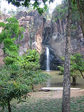
- Sakunothayan Arboretum - Botanical Garden on Highway 12 with a beautiful waterfall.
- Wang Thong Valley (also called Khaek River) with its rapids and waterfalls.
- National parks:
- Thung Salaeng Luang National Park
- Phu Hin Rong Kla National Park
- Namtok Chat Trakan National Park - Chat Trakan waterfall is the source of the Khwae Noi River
Symbols
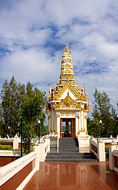
The seal shows the Phra Phutthachinnarat, one of the most beautiful Buddha figures in Thailand in the classic Sukhothai style. The figure is in the Wat Phra Sri Rattana Mahathat of Phitsanulok, called Wat Yai for short .
The local tree is the jasmine tree (also Indian cork tree, Millingtonia hortensis ), the local flower is that of the yellow flame tree (laburnum, flamboyant) Peltophorum pterocarpum .
The motto of Phitsanulok Province is:
- "The city is home to Phra Phuttha Chinnarat, the most beautiful Buddha image ,
birthplace of King Naresuan , the Great,
Fascinating boat and raft houses are on both banks of the river,
Dried bananas attract buyers,
Large caves and waterfalls blind the eyes of visitors."
Others
The Thai Bangkaew dog breed originated in Phitsanulok Province .
Administrative units
Provincial Administration
The province is divided into 9 Amphoe ('districts' or 'counties'). These are further subdivided into 93 tambon ('subdistricts' or 'municipalities') and 993 muban ('villages').
|
Local administration
A provincial administrative organization ( Thai องค์การ บริหาร ส่วน จังหวัด , short อบ จ. , Ongkan Borihan suan Changwat ; English Provincial Administrative Organization , PAO) exists for the entire area of the province .
The province also has 27 thesaban ('municipalities') - including a "large city" (the provincial capital), a "city" and 25 "small towns" - and 75 tambon administrative organizations.
Individual evidence
- ↑ Governor of Phitsanulok (PDF; 63 kB)
- ^ A b Gross Provincial Product at Current Market Prices: Northern Provinces, National Economic and Social Development Board, 2011.
- ↑ a b Thailand in Figures (2012), p. 257; Data according to "Office of the National Economic and Social Development Board, Office of the Prime Minister".
- ↑ "Industry" includes: Mining and quarrying; Manufacturing; Electricity, gas and water supply; Construction .
- ^ "Others" include: Wholesale and retail trade; Hotels and restaurants; Transport, storage and communication; Real estate; Education; Health and social work, ...
- ↑ Chris Baker , Pasuk Phongpaichit: A History of Thailand. 2nd edition, Cambridge University Press, Melbourne 2009, p. 10.
literature
- Thailand in Figures 2011 . Nonthaburi: Alpha Research 13 A. 2011. ISBN 978-616752603-4 .
Web links
Coordinates: 16 ° 50 ′ N , 100 ° 16 ′ E


