
Si Sa Ket (Province)
| Si Sa Ket | |
|---|---|
| ศรีสะเกษ | |

|
|
| statistics | |
| Capital: | Si Sa Ket |
| Telephone code: | 045 |
| Surface: |
8,840.0 km² 21. |
| Residents: |
1,446,345 (2009) 9. |
| Population density : | 164 E / km² 21. |
| ISO 3166-2 : | |
| Governor : | Prathip Kiratirekha |
| map | |
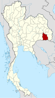  |
|
Si Sa Ket ( Thai : ศรีสะเกษ , also referred to as Si Saket or Sisaket ) is a province ( Changwat ) in the northeast region of Thailand , the so-called Isan .
The "capital" of the province of Si Sa Ket is also called Si Sa Ket .
geography

The province lies in the valley of the Mae Nam Mun (Mun River) , a tributary of the Mekong . In the south, the Dongrek Mountains form the border with Cambodia .
| Neighboring provinces and areas: | |
|---|---|
| north | Yasothon and Roi Et |
| east | Ubon Ratchathani |
| south | National border with Cambodia |
| west | Surin |
Important cities
Important rivers
- Mae Nam Mun
- Huai Samran
climate
The climate is tropical - monsoonal . The maximum temperature in 2009 was 36.8 ° C, the lowest temperature was measured at 14.8 ° C. On 114 rainy days fell in the same year 1597.7 mm of precipitation.
population
Four major minorities live in the province: the Khmer , the Kuy (or Suai ; according to the 2000 census, 26.2% of the population spoke Khmer or Kuy), the Lao and the Yoe .
Economy and Importance
In 2008, the "Gross Provincial Product" (was GDP ) of the province of 47,486 million baht .
Data
The table below shows the share of the economic sectors in the "Gross Provincial Product" in percent:
| Industry | 2006 | 2007 | 2008 |
|---|---|---|---|
| Agriculture | 22.9 | 23.0 | 21.2 |
| Industry | 4.5 | 6.4 | 6.9 |
| Other | 72.6 | 70.6 | 71.9 |
Land use
The following land use is documented for the province:
- Forest area: 668,386 Rai (417.7 km²), 12.1% of the total area
- Agricultural area: 2,832,195 Rai (1,770.1 km²), 51.3% of the total area
- Unclassified area: 2,024,404 rai (1,265.3 km²), 36.6% of the total area
The economy is characterized by agriculture and fishing . The province of Si Sa Ket has a total of 697 wetlands with an area of 49.4 km², which are used more or less intensively for agriculture.
The Tourism plays a minor role, but is growing.
Dams
Ang Huai Ta Mai
traffic
Rail transport
- Nong Waeng Railway Station
- Ban Khlo train station
- Kanthararom train station
- Si Sa Ket train station
- Ban Tae Railway Station
- Uthumphon Phisai train station
- Huai Thap Than Railway Station
Bus transport
Si Sa Ket Bus Terminal
Educational institutions
- Sisaket Rajabhat University in Mueang Si Sa Ket
- Ramkhamhaeng University in Mueang Si Sa Ket
- Chaloem Kanchanaphisek Technology Si Sa Ket College in Mueang Si Sa Ket
- Si Sa Ket Technical College in Mueang Si Sa Ket
- Si Sa Ket Polytechnic College in Si Sa Ket
- Si Sa Ket Industrial and Community Education College in Mueang Si Sa Ket
- Si Sa Ket Agriculture and Technology College in Mueang Si Sa Ket
- Si Sa Ket Physical Education College in Mueang Si Sa Ket
- Satri Si Sa Ket School in Mueang Si Sa Ket
Health facilities
- Si Sa Ket Hospital in Mueang Si Sa Ket
- Pracharak Hospital in Mueang Si Sa Ket
- Uthumphon Phisai Hospital
- Huai Thap Than Hospital
- Kanthararom Hospital
- Mueang Chan Hospital
- Khukhan Hospital
- Kantharalak Hospital in Nam Om
history
Many remains in the province point to a long history since the Khmer Empire of Angkor in the 12th century. According to tradition, Si Sa Ket was previously called Nakhon Lamguan, later known as Khukhan .
In 1759 Khukhan was granted city status and the local chief Lung Kaeo Suwan was appointed governor with the title Phra Kraiphakdi. During the reign of King Chulalongkorn (Rama V .; r. 1868–1910), the city's population was relocated to its current location. However, the city kept its name. It was not until 1938 that the province and the capital were renamed Si Sa Ket.
Attractions

- The Khao Phra Viharn National Park is located in the Dongrek Mountains in the far south of the province on the border with Cambodia. It was inaugurated on March 20, 1998 and is 130 km² in size. Its name comes from Khao Phra Viharn (in Khmer : Prasat Preah Vihear ), a Khmer temple that is located on Cambodian territory. This has often led to legal disputes in the past, so the temple has been inaccessible for most of the recent past. In a border survey for the Franco-Siamese Treaty of 1907, the temple was confirmed on the Cambodian side, although the border runs in other places along the watershed . In 1962, the International Court of Justice confirmed the 1907 borders and officially settled the dispute. The temple is one of the most impressive examples of Khmer sacred architecture
- Prasat Kamphaeng Yai - an impressive ruin complex with a monumental gate and artistic sculptures; the inner wall is almost completely preserved
- Local festivals:
- Lamduan Festival - The annual Lamduan Festival is held on the first weekend in March, where local minorities present their handicrafts and culture
- Marathon run - on the Sunday of the third week in August there is an annual half-marathon and quarter-marathon run; the route goes uphill to Khao Phra Viharn and is very demanding
- Si Sa Ket Aquarium
Symbols
-pano-1.jpg)
The seal shows the Prasat Hin Ban Samo in the Prang Ku district, a Khmer temple that is around 1000 years old.
The local flower is White Cheesewood ( Lamduan, Melodorum fruticosum Lour. ). The six petals indicate the original six districts (Amphoe) of the province: Khukhan, Kantharalak, Uthumphon Phisai, Kanthararom, Rasi Salai and Khun Han.
The motto of Si Sa Ket Province is:
- "The land of the ancient Khmer castles,
good onions and tasty garlic is grown,
the Princess Mother's Park with Lamduan flowers is honored by us,
the province is known for love and unity among different cultures."
Administrative units
Provincial Administration
The province of Si Sa Ket is divided into 22 amphoe ('districts' or 'counties'). These are further subdivided into 206 tambon ('subdistricts' or 'parishes') and 2411 muban ('villages').
|

Local administration
A provincial administrative organization ( บริหาร ส่วน จังหวัด , อบ จ for short , Ongkan Borihan suan Changwat ; English Provincial Administrative Organization , PAO) exists for the entire area of the province .
There are two cities ( เทศบาล เมือง - Thesaban Mueang ) in the province : Si Sa Ket ( เทศบาล เมือง ศรีสะเกษ ) and Kantharalak ( เทศบาล เมือง กันทรลักษ์ ). There are also 17 small towns ( เทศบาล ตำบล - Thesaban Tambon ).
Individual evidence
- ↑ Governor of the Province ( Memento of the original from June 7, 2015 in the Internet Archive ) Info: The archive link was inserted automatically and has not yet been checked. Please check the original and archive link according to the instructions and then remove this notice.
- ↑ a b c General information about Si Sa Ket ( Memento of the original from December 1, 2010 in the Internet Archive ) Info: The archive link has been inserted automatically and has not yet been checked. Please check the original and archive link according to the instructions and then remove this notice.
- ↑ Key indicators of the population and households, Population and Housing Census 1990 and 2000: Si Sa Ket
- ↑ Thailand in Figures (2011), p. 335.
- ↑ a b Thailand in Figures (2011)
- ↑ Edmund JV Oh, Blake D. Ratner, Simon Bush, Komathi Kolandai and Terence Y. Too (eds.): Wetlands Governance in the Mekong Region: country reports on the legal-institutional framework and economic valuation of aquatic resources . 2005. (PDF; 4.7 MB)
- ^ Sisaket Rajabhat University ( Memento from September 10, 2010 in the Internet Archive )
- ↑ History of the Province ( Memento of the original from March 25, 2010 in the Internet Archive ) Info: The archive link was inserted automatically and has not yet been checked. Please check the original and archive link according to the instructions and then remove this notice.
- ↑ Department of Provincial Administration : As of 2011 (in Thai)
literature
- Thailand in Figures 2011 . Nonthaburi: Alpha Research 13 A. 2011. ISBN 9786167526034 .
Web links
- Provincial Administration website (in Thai and English)
- Overview map of the province of Si Sa Ket (names in English and Thai) [last accessed on November 14, 2013]
- Information about the Khao Phra Viharn National Park (in English)
North : Chiang Mai | Chiang Rai | Kamphaeng Phet | Lampang | Lamphun | Mae Hong Son | Nakhon Sawan | Nan | Phayao | Phetchabun | Phichit | Phitsanulok | Phrae | Sukhothai | Tak | Uthai Thani | Uttaradit
Northeast : Amnat Charoen | Bueng Kan | Buri Ram | Chaiyaphum | Kalasin | Khon Kaen | Loei | Maha Sarakham | Mukdahan | Nakhon Phanom | Nakhon Ratchasima | Nong Bua Lam Phu | Nong Khai | Roi Et | Sakon Nakhon | Si Sa Ket | Surin | Ubon Ratchathani | Udon Thani | Yasothon
Central : Ang Thong | Ayutthaya | Bangkok | Chachoengsao | Chai Nat | Chanthaburi | Chon Buri | Kanchanaburi | Lop Buri | Nakhon Nayok | Nakhon Pathom | Nonthaburi | Pathum Thani | Phetchaburi | Prachin Buri | Prachuap Khiri Khan | Ratchaburi | Rayong | Sa Kaeo | Samut Prakan | Samut Sakhon | Samut Songkhram | Saraburi | Sing Buri | Suphan Buri | Stepped
South : Chumphon | Krabi | Nakhon Si Thammarat | Narathiwat | Pattani | Phang-nga | Phatthalung | Phuket | Ranong | Satun | Songkhla | Surat Thani | Trang | Yala
Coordinates: 15 ° 7 ′ N , 104 ° 19 ′ E