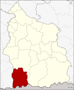
Phu Sing district
|
Phu Sing ภู สิงห์ |
|
|---|---|
| Province: | Si Sa Ket |
| Surface: | 940.1 km² |
| Residents: | 52,715 (2013) |
| Population density : | 53.8 U / km² |
| ZIP : | 33140 |
| Geocode : | 3317 |
| map | |

|
|
Amphoe Phu Sing ( Thai อำเภอ ภู สิงห์ ) is a district ( Amphoe - Administrative District) in the southwest of the Si Sa Ket Province . The province of Si Sa Ket is located in the northeast region of Thailand , the so-called Isan .
geography
Amphoe Phu Sing borders the following districts (clockwise from the west): Amphoe Buachet in Surin Province , and Amphoe Khukhan and Khun Han in Si Sa Ket Province. To the south lies the Oddar Meanchey Province of Cambodia .
history
Phu Sing was initially set up as a “branch circle” ( King Amphoe ) on April 1, 1991 , by separating the six Tambon Khok Tan, Huai Ta Mon, Huai Tuekchu, Lalom, Takhian Ram and Dong Rak from the Amphoe Khukhan. On September 8, 1995, it was promoted to Amphoe.
administration
Provincial Administration
Phu Sing County is divided into seven tambon ("subdistricts" or "parishes"), which are further subdivided into 86 muban ("villages").
| No. | Surname | Thai | Muban | Pop. |
|---|---|---|---|---|
| 1. | Khok Tan | โคก ตาล | 13 | 7,562 |
| 2. | Huai Ta Mon | ห้วย ตาม อ ญ | 10 | 6,274 |
| 3. | Huai Tuekchu | ห้วย ตึ๊ก ชู | 18th | 11,889 |
| 4th | La Lom | ละ ลม | 13 | 7,687 |
| 5. | Takhian Ram | ตะเคียน ราม | 14th | 6,199 |
| 6th | Dong Rak | ดง รัก | 8th | 5,997 |
| 7th | Phrai Phatthana | ไพร พัฒนา | 10 | 7.107 |
Local administration
There are seven " Tambon Administrative Organizations " ( องค์การ บริหาร ส่วน ตำบล - Tambon Administrative Organizations, TAO) in the district:
- Khok Tan (Thai: องค์การ บริหาร ส่วน ตำบล โคก ตาล )
- Huai Ta Mon (Thai: องค์การ บริหาร ส่วน ตำบล ห้วย ตาม อ ญ )
- Huai Tuekchu (Thai: องค์การ บริหาร ส่วน ตำบล ห้วย ตึ๊ก ชู )
- La Lom (Thai: องค์การ บริหาร ส่วน ตำบล ละ ลม )
- Takhian Ram (Thai: องค์การ บริหาร ส่วน ตำบล ตะเคียน ราม )
- Dong Rak (Thai: องค์การ บริหาร ส่วน ตำบล ดง รัก )
- Phrai Phatthana (Thai: องค์การ บริหาร ส่วน ตำบล ไพร พัฒนา )
Individual evidence
- ↑ ประกาศ กระทรวง มหาดไทย เรื่อง แบ่ง เขต ท้องที่ อำเภอ ขุขันธ์ จังหวัด ศรีสะเกษ ตั้ง เป็น กิ่ง อำเภอ ภู สิงห์ . In: Royal Gazette . 108, No. 15 ง , January 31, 1991, p. 1069.
- ↑ พระราชกฤษฎีกา ตั้ง อำเภอ ด่าน มะขาม เตี้ย อำเภอ แก่ง หาง แมว อำเภอ ภักดี ชุมพล อำเภอ เวียง แก่น อำเภอ แม่ วาง อำเภอ ถ้ำ พรรณ รา อำเภอ บ่อ เกลือ อำเภอ อำเภอ โนน สุวรรณ อำเภอ ห้วย ราช อำเภอ แม่ ลาน อำเภอ บางแก้ว อำเภอ ป่า พะยอม อำเภอ หนอง ม่วง ไข่ สุ ราช สี สี สี สี สี สี สี อำเภอ จัง หาร อำเภอ บ้าน ธิ อำเภอ ภู สิงห์ อำเภอ บาง กล่ำ อำเภอ วัง ม่วง และ อำเภอ นา ยูง พ.ศ. ๒๕๓๘ . In: Royal Gazette . 112, No. 32 ก , August 8, 1995, pp. 1-3.
- ↑ 2013 population statistics ( Thai ) Department of Provincial Administration. Retrieved August 3, 2014.
Web links
Coordinates: 14 ° 33 ' N , 104 ° 8' E