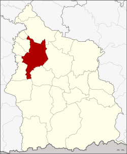
Amphoe Uthumphon Phisai
|
Uthumphon Phisai อุทุมพรพิสัย |
|
|---|---|
| Province: | Si Sa Ket |
| Surface: | 407.9 km² |
| Residents: | 107,348 (2013) |
| Population density : | 268.7 U / km² |
| ZIP : | 33120 |
| Geocode : | 3310 |
| map | |

|
|
Amphoe Uthumphon Phisai (in Thai อำเภอ อุทุมพรพิสัย ) is a district ( Amphoe - administrative district) in the west of the province of Si Sa Ket . The province of Si Sa Ket is located in the northeast region of Thailand , the so-called Isan .
geography
Uthumphon Phisai district borders the following districts (clockwise from the north): Rasi Salai , Mueang Si Sa Ket , Wang Hin , Prang Ku , Huai Thap Than , Mueang Chan , Pho Si Suwan and Bueng Bun . All Amphoe are in Si Sa Ket Province.
economy
As part of the One Tambon One Product Initiative (OTOP), numerous award-winning products are made from cotton and matmi silk in the district.
history
The history of the district goes back to Mueang Uthumphon Phisai, which became the Amphoe Phachim Si Sa Ket ( อำเภอ ป จิ ม ศี ร์ ษะ เก ษ ) in 1911 . In 1913 the name was changed back to Uthomphon Phisai. The administration building was located in Ban Samrong Yai, Tambon Samrong.
Attractions
- Prasat Hin Sa Kamphaeng Yai - ruins of a Khmer temple from the 13th century
- Prasat Hin Sa Kamphaeng Noi - ruins of a small Khmer prang from the 10th century
administration
Provincial Administration
The district of Uthumphon Phisai is divided into 19 tambon ("subdistricts" or "communities"), which are further divided into 232 muban ("villages").
| No. | Surname | Thai | Muban | Pop. |
|---|---|---|---|---|
| 1. | Kamphaeng | กำแพง | 9 | 10,599 |
| 2. | I lam | อี่ ห ล่ำ | 12 | 4,091 |
| 3. | Kan Lueang | ก้านเหลือง | 20th | 8,961 |
| 4th | Thung Chai | ทุ่ง ไชย | 9 | 4,545 |
| 5. | Samrong | สำโรง | 17th | 7,683 |
| 6th | Khaem | แขม | 12 | 4,291 |
| 7th | Nong Hai | หนอง ไฮ | 12 | 5,030 |
| 8th. | Khayung | ขะ ยูง | 13 | 5,273 |
| 10. | Ta Ket | ตา เก ษ | 12 | 3,884 |
| 11. | Hua Chang | หัว ช้าง | 11 | 4,480 |
| 12. | Rank Raeng | รัง แร้ง | 12 | 5,262 |
| 14th | Tae | แต้ | 8th | 2,868 |
| 15th | Khae | แข้ | 9 | 4,596 |
| 16. | Pho Chai | โพธิ์ชัย | 11 | 4,840 |
| 17th | Pa Ao | ปะ อาว | 14th | 5,034 |
| 18th | Nong Hang | หนอง ห้าง | 17th | 8,431 |
| 22nd | Sa Kamphaeng Yai | สระ กำแพง ใหญ่ | 14th | 8,480 |
| 24. | Khok Lam | โคก ห ล่าม | 10 | 3,662 |
| 25th | Khok Chan | โคก จาน | 10 | 5,338 |
Local administration
There are five municipalities with "small town" status ( Thesaban Tambon ) in the district:
- Uthumphon Phisai (Thai: เทศบาล ตำบล อุทุมพรพิสัย ), consisting of the remaining parts of the Tambon Kamphaeng.
- Tae (Thai: เทศบาล ตำบล แต้ ), consisting of the entire Tambon Tae.
- Sa Kamphaeng Yai (Thai: เทศบาล ตำบล สระ กำแพง ใหญ่ ), consisting of the entire tambon Sa Kamphaeng Yai.
- Khok Chan (Thai: เทศบาล ตำบล โคก จาน ), consisting of the entire tambon Khok Chan.
- Kamphaeng (Thai: เทศบาล ตำบล กำแพง ), consisting of parts of the Tambon Kamphaeng.
There are also 15 " Tambon Administrative Organizations " ( องค์การ บริหาร ส่วน ตำบล - Tambon Administrative Organizations, TAO):
- I Lam (Thai: องค์การ บริหาร ส่วน ตำบล อี่ ห ล่ำ )
- Kan Lueang (Thai: องค์การ บริหารส่วน ตำบล ก้านเหลือง )
- Thung Chai (Thai: องค์การ บริหาร ส่วน ตำบล ทุ่ง ไชย )
- Samrong (Thai: องค์การ บริหาร ส่วน ตำบล สำโรง )
- Khaem (Thai: องค์การ บริหาร ส่วน ตำบล แขม )
- Nong Hai (Thai: องค์การ บริหาร ส่วน ตำบล หนอง ไฮ )
- Khayung (Thai: องค์การ บริหาร ส่วน ตำบล ขะ ยูง )
- Ta Ket (Thai: องค์การ บริหาร ส่วน ตำบล ตา เก ษ )
- Hua Chang (Thai: องค์การ บริหาร ส่วน ตำบล หัว ช้าง )
- Rank Raeng (Thai: องค์การ บริหาร ส่วน ตำบล รัง แร้ง )
- Khae (Thai: องค์การ บริหาร ส่วน ตำบล แข้ )
- Pho Chai (Thai: องค์การ บริหาร ส่วน ตำบล โพธิ์ชัย )
- Pa Ao (Thai: องค์การ บริหาร ส่วน ตำบล ปะ อาว )
- Nong Hang (Thai: องค์การ บริหาร ส่วน ตำบล หนอง ห้าง )
- Khok Lam (Thai: องค์การ บริหาร ส่วน ตำบล โคก ห ล่าม )
Individual evidence
- ↑ List of OTOP products from Uthumphon Phisai (in Thai; last accessed on March 7, 2010)
- ↑ แจ้ง ความ กระทรวง มหาดไทย เรื่อง เปลี่ยน นาม อำเภอ . In: Royal Gazette . 30, No. 0 ง , October 12, 1913, pp. 1536–1537.
- ↑ 2013 population statistics ( Thai ) Department of Provincial Administration. Retrieved August 3, 2014.
Web links
- More information about Amphoe Uthumphon Phisai at amphoe.com (in Thai language)
Coordinates: 15 ° 7 ' N , 104 ° 8' E

