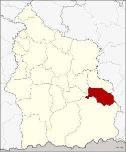
Benchalak district
|
Benchalak เบญจ ลัก ษ์ |
|
|---|---|
| Province: | Si Sa Ket |
| Surface: | 331.3 km² |
| Residents: | 36,728 (2013) |
| Population density : | 108.1 U / km² |
| ZIP : | 33110 |
| Geocode : | 3319 |
| map | |

|
|
Amphoe Benchalak (in Thai อำเภอ เบญจ ลัก ษ์ ) is a district ( Amphoe - administrative district) in the province of Si Sa Ket . The province of Si Sa Ket is located in the northeast region of Thailand , the so-called Isan .
geography
Benchalak District borders the following districts are (from south clockwise) to the Amphoe Kantharalak , Si Rattana , Nam Kliang and Non Khun in the province of Si Sa Ket, and to the Amphoe Det Udom and Thung Si Udom the province of Ubon Ratchathani .
history
Benchalak was set up on May 31, 1993 initially as a "branch circle" ( King Amphoe ) by separating five tambon from the Amphoe Kantharalak. On December 5, 1996, it was promoted to Amphoe.
administration
Provincial Administration
Benchalak County is divided into five tambon ("subdistricts" or "parishes"), which are further subdivided into 67 muban ("villages").
| No. | Surname | Thai | Muban | Pop. |
|---|---|---|---|---|
| 1. | Siao | เสียว | 14th | 8,789 |
| 2. | Nong Wa | หนอง หว้า | 15th | 7,294 |
| 3. | Nong Ngu Lueam | หนอง งูเหลือม | 13 | 6,679 |
| 4th | Nong Hang | หนอง ฮา ง | 12 | 6,701 |
| 5. | Tha Khlo | ท่า คล้อ | 13 | 7,265 |
Local administration
There are five " Tambon Administrative Organizations " ( องค์การ บริหาร ส่วน ตำบล - Tambon Administrative Organizations, TAO) in the district:
- Siao (Thai: องค์การ บริหาร ส่วน ตำบล เสียว )
- Nong Wa (Thai: องค์การ บริหาร ส่วน ตำบล หนอง หว้า )
- Nong Ngu Lueam (Thai: องค์การ บริหาร ส่วน ตำบล หนอง งูเหลือม )
- Nong Hang (Thai: องค์การ บริหาร ส่วน ตำบล หนอง ฮา ง )
- Tha Khlo (Thai: องค์การ บริหาร ส่วน ตำบล ท่า คล้อ )
Individual evidence
- ↑ ประกาศ กระทรวง มหาดไทย เรื่อง แบ่ง เขต ท้องที่ อำเภอ กันทรลักษ์ จังหวัด ศรีสะเกษ ตั้ง เป็น กิ่ง อำเภอ เบญจ ลัก ษ์ . In: Royal Gazette . 110, No. 74 ง , June 8, 1993, p. 18.
- ↑ พระราชกฤษฎีกา ตั้ง อำเภอ เหนือ คลอง อำเภอ นา ยาย อาม อำเภอ ท่า ตะเกียบ อำเภอ ขุน ตาล อำเภอ แม่ ฟ้า หลวง อำเภอ แม่ ลาว อำเภอ รั ษ ฎา อำเภอ อำเภอ พุทธ มณฑล อำเภอ วัง วัง น้ำ เขียว อำเภอ เจาะ ไอ ร้อง อำเภอ ชำนิ อำเภอ โนน ดินแดง อำเภอ ปาง สนธิ อำเภอ อำเภอ อำเภอ อำเภอ อำเภอ อำเภอ อำเภอ หนอง ม่วง อำเภอ เบญจ ลัก ษ์ อำเภอ โพน นา แก้ว อำเภอ บุ่ง คล้า อำเภอ ดอน มดแดง และ อำเภอ ลือ อำนาจ พ.ศ. ๒๕๓๙ . In: Royal Gazette . 113, No. 62 ก , November 20, 1996, pp. 5-8.
- ↑ 2013 population statistics ( Thai ) Department of Provincial Administration. Retrieved August 3, 2014.
Web links
Coordinates: 14 ° 48 ' N , 104 ° 40' E