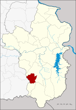
Amphoe Thung Si Udom
|
Thung Si Udom ทุ่ง ศรี อุดม |
|
|---|---|
| Province: | Ubon Ratchathani |
| Surface: | 307.0 km² |
| Residents: | 28,477 (2013) |
| Population density : | 87.9 U / km² |
| ZIP : | 34160 |
| Geocode : | 3426 |
| map | |

|
|
Amphoe Thung Si Udom ( Thai : อำเภอ ทุ่ง ศรี อุดม ) is a district ( Amphoe ) in the southwest of the Ubon Ratchathani Province . The province of Ubon Ratchathani is located in the northeast region of Thailand , the so-called Isan .
geography
Amphoe Thung Si Udom borders the following districts (clockwise from the north): Amphoe Det Udom and Nam Khun in the province of Ubon Ratchathani, and Amphoe Kantharalak in the province of Si Sa Ket .
history
Thung Si Udom was initially set up on April 1, 1992 as a "branch circle" ( King Amphoe ) by separating six tambon from Amphoe Det Udom . On June 1, 1993, Tambon Thung Thoeng was reassigned back to Det Udom. On October 10, 1997, Thung Si Udom was promoted to Amphoe.
Attractions
- Prasat Ban Ben - ruins of a Khmer temple from the 11th century
Administrative units
Provincial Administration
The district of Thung Si Udom is divided into five tambon ("subdistricts" or "municipalities"), which are further subdivided into 52 muban ("villages").
| No. | Surname | Thai | Muban | Pop. |
|---|---|---|---|---|
| 2. | Nong Om | หนอง อ้ม | 10 | 5,907 |
| 3. | Well Kasem | นา เกษม | 11 | 5,835 |
| 4th | Kut Ruea | กุด เรือ | 10 | 6.251 |
| 5. | Khok Chamrae | โคก ชำแระ | 10 | 5,943 |
| 6th | Well hom | นา ห่อ ม | 11 | 4,541 |
Local administration
There are five " Tambon Administrative Organizations " ( องค์การ บริหาร ส่วน ตำบล - Tambon Administrative Organizations, TAO) in the district:
- Nong Om (Thai: องค์การ บริหาร ส่วน ตำบล หนอง อ้ม )
- Na Kasem (Thai: องค์การ บริหาร ส่วน ตำบล นา เกษม )
- Kut Ruea (Thai: องค์การ บริหาร ส่วน ตำบล กุด เรือ )
- Khok Chamrae (Thai: องค์การ บริหาร ส่วน ตำบล โคก ชำแระ )
- Na Hom (Thai: องค์การ บริหาร ส่วน ตำบล นา ห่อ ม )
Individual evidence
- ↑ ประกาศ กระทรวง มหาดไทย เรื่อง แบ่ง เขต ท้องที่ อำเภอ เดชอุดม จังหวัด อุบลราชธานี ตั้ง เป็น กิ่ง อำเภอ ทุ่ง ศรี อุดม . In: Royal Gazette . 109, No. 53 ง ฉบับ พิเศษ (special), April 22, 1992, p. 14.
- ↑ ประกาศ กระทรวง มหาดไทย เรื่อง เปลี่ยนแปลง เขต กิ่ง อำเภอ ทุ่ง ศรี อุดม อำเภอ เดชอุดม จังหวัด อุบลราชธานี . In: Royal Gazette . 110, No. 74 ง , June 8, 1993, p. 13.
- ↑ พระราชกฤษฎีกา ตั้ง อำเภอ หนอง ปรือ อำเภอ ห้วย กระเจา อำเภอ ทราย ทอง วัฒนา อำเภอ ปาง ศิลา ทอง อำเภอ เนิน สง่า อำเภอ นา ทม อำเภอ พระ พรหม อำเภอ แม่ แม่ วงก์ อำเภอ สอง แคว อำเภอ บ้าน ใหม่ ไชย พจน์ อำเภอ ไทย เจริญ อำเภอ กา บัง อำเภอ พยุ จันทร์ อำเภอ เมือง เมือง เมือง เมือง เมือง เมือง เมือง ภู พาน อำเภอ คลอง หอยโข่ง อำเภอ เขา ฉกรรจ์ อำเภอ นา วัง อำเภอ พิบูลย์ รักษ์ และ อำเภอ ทุ่ง ศรี อุดม พ.ศ. ๒๕๔๐ . In: Royal Gazette . 114, No. 50 ก , September 26, 1997, pp. 24-27.
- ↑ 2013 population statistics ( Thai ) Department of Provincial Administration. Retrieved August 4, 2014.
Web links
- More information about Amphoe Thung Si Udom at amphoe.com (in Thai)
- Amphoe Administration website (in Thai)
Coordinates: 14 ° 44 ' N , 104 ° 55' E

