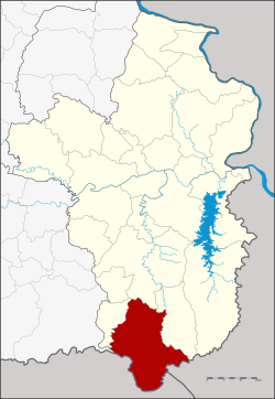
Nam Yuen district
|
Nam Yuen น้ำยืน |
|
|---|---|
| Province: | Ubon Ratchathani |
| Surface: | 854.5 km² |
| Residents: | 69,613 (2013) |
| Population density : | 65.77 U / km² |
| ZIP : | 34260 |
| Geocode : | 3409 |
| map | |

|
|
Amphoe Nam Yuen ( Thai : อำเภอ น้ำยืน ) is a district ( Amphoe - administrative district) in the south of Ubon Ratchathani Province . The province of Ubon Ratchathani is located in the northeast region of Thailand , the so-called Isan .
etymology
The name Nam Yuen initially comes from the village of Nam Yuen, where the first administration building was located. Furthermore, three rich rivers flow in the area of Nam Yuen, the Bon ( ห้วย บอน ), the Chong ( ห้วย โช ง ) and the Ta Em ( ห้วย ตา เอ็ ม ), therefore Nam Yuen means “permanent water” in the Thai language.
geography
Amphoe Nam Yuen borders the following counties (clockwise from west): Amphoe Nam Khun , Det Udom and Na Chaluai in the province of Ubon Ratchathani, as well as the province of Champasak of Laos and the province of Preah Vihear of Cambodia .
The main water resource in the county is the Dom Yai River .
history
Nam Yuen was initially set up as a “branch circle” ( King Amphoe ) on March 17, 1969 , by separating the four Tambon Song, Ta Kao, Yang and Dom Pradit from the Det Udom district. It was promoted to Amphoe on March 29, 1974.
Administrative units
Provincial Administration
Nam Yuen County is divided into seven tambon ("subdistricts" or "parishes"), which are further subdivided into 102 muban ("villages").
| No. | Surname | Thai | Muban | Pop. |
|---|---|---|---|---|
| 1. | song | โซ ง | 11 | 8,497 |
| 3. | Yang | ยาง | 13 | 7,343 |
| 4th | Dom Pradit | โดม ประดิษฐ์ | 21st | 16,288 |
| 6th | Bu Pueai | บุ เปื อย | 15th | 9,217 |
| 7th | Si Wichian | สี วิเชียร | 16 | 14,747 |
| 9. | Yang Yai | ยาง ใหญ่ | 13 | 6.235 |
| 11. | Kao Kham | เก่า ขาม | 13 | 7,286 |
Note: The missing numbers (geocodes) refer to the tambon that belong to Nam Khun today.
Local administration
There are three municipalities with "small town" status ( Thesaban Tambon ) in the district:
- Song (Thai: เทศบาล ตำบล โซ ง ), consisting of parts of the tambon song.
- Si Wichian (Thai: เทศบาล ตำบล สี วิเชียร ), consisting of parts of the tambon Si Wichian.
- Nam Yuen (Thai: เทศบาล ตำบล น้ำยืน ), consisting of the remaining parts of the Tambon Song and Si Wichian.
There are also five " Tambon Administrative Organizations " ( องค์การ บริหาร ส่วน ตำบล - Tambon Administrative Organizations, TAO):
- Yang (Thai: องค์การ บริหาร ส่วน ตำบล ยาง )
- Dom Pradit (Thai: องค์การ บริหาร ส่วน ตำบล โดม ประดิษฐ์ )
- Bu Pueai (Thai: องค์การ บริหาร ส่วน ตำบล บุ เปื อย )
- Yang Yai (Thai: องค์การ บริหาร ส่วน ตำบล ยาง ใหญ่ )
- Kao Kham (Thai: องค์การ บริหาร ส่วน ตำบล เก่า ขาม )
Individual evidence
- ↑ ประกาศ กระทรวง มหาดไทย เรื่อง แบ่ง ท้องที่ ตั้ง เป็น กิ่ง อำเภอ . In: Royal Gazette . 86, No. 24 ง , March 25, 1969, p. 1017.
- ↑ พระราชกฤษฎีกา ตั้ง อำเภอ เขาวง อำเภอ เชียงม่วน อำเภอ ดอนตาล อำเภอ ชาติตระการ อำเภอ ภูเรือ อำเภอ เคียน ซา อำเภอ น้ำโสม อำเภอ หนองวัวซอ และ อำเภอ น้ำยืน พ.ศ. ๒๕๑๗ . In: Royal Gazette . 91, No. 54 ก ฉบับ พิเศษ (special), March 28, 1974, pp. 30-33.
- ↑ 2013 population statistics ( Thai ) Department of Provincial Administration. Retrieved August 4, 2014.
Web links
- More information about the Nam Yuen district at amphoe.com (in Thai)
- Amphoe Administration website (in Thai)
Coordinates: 14 ° 29 ' N , 105 ° 0' E
