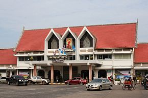
Warin Chamrap district
|
Warin Chamrap วารินชำราบ |
|
|---|---|
| Province: | Ubon Ratchathani |
| Surface: | 691.0 km² |
| Residents: | 160,317 (2013) |
| Population density : | 226.3 U / km² |
| ZIP : | 34190, 34310 |
| Geocode : | 3415 |
| map | |

|
|
Amphoe Warin Chamrap ( Thai : อำเภอ วารินชำราบ ) is a district ( Amphoe - administrative district) in the west of Ubon Ratchathani Province . The province of Ubon Ratchathani is located in the northeast region of Thailand , the so-called Isan .
geography
Neighboring counties (from the north clockwise): the Amphoe Mueang Ubon Ratchathani , Sawang Wirawong , Na Yia , Det Udom and Samrong of the province of Ubon Ratchathani, and Amphoe Kanthararom of the province of Si Sa Ket .
The county's main water resource is the Mae Nam Mun (Mun River) .
history
The district was renamed Warin Chamrap by Thaksin Ubon ( ทักษิณ อุบล ) in 1913 .
traffic
Since 1939 the eastern terminus of the north-east line of the Thai state railway from Bangkok via Nakhon Ratchasima has been in Warin Chamrap .
education
The Ubon Ratchathani University is Warin Chamrap in the district.
Well-known Buddhist temples
- Wat Pah Nanachat - Buddhist forest monastery ( Wat ) of the Thai forest tradition north of Tambon Bung Wai in a forest.
- Wat Nong Pah Phong - Buddhist forest monastery of the great and influential monk Ajahn Chah .
Administrative units
Provincial Administration
The district of Warin Chamrap is divided into 16 tambon ("subdistricts" or "municipalities"), which are further subdivided into 192 muban ("villages").
| No. | Surname | Thai | Muban | Pop. |
|---|---|---|---|---|
| 1. | Wasin Chamrap | วารินชำราบ | - | 28,444 |
| 2. | That | ธาตุ | 11 | 5,834 |
| 4th | Tha Lat | ท่า ลาด | 12 | 7.130 |
| 5. | Non Non | โนน โหน น | 12 | 6,580 |
| 7th | Khu Mueang | คูเมือง | 12 | 7,533 |
| 8th. | Sa Saming | สระ สมิง | 16 | 7,668 |
| 10. | Kham Nam Saep | คำ น้ำ แซบ | 10 | 9,566 |
| 11. | Bung Wai | บุ่ง หวาย | 20th | 10,922 |
| 15th | Kham Khwang | คำ ขวาง | 10 | 7,744 |
| 16. | Pho Yai | โพธิ์ ใหญ่ | 13 | 7,692 |
| 18th | Saen Suk | แสนสุข | 20th | 24,630 |
| 20th | Nong Kin Phen | หนอง กิน เพล | 9 | 7,327 |
| 21st | Non Phueng | โนน ผึ้ง | 11 | 8,060 |
| 22nd | Mueang Si Khai | เมือง ศรี ไค | 11 | 6.237 |
| 24. | Huai Khayung | ห้วย ขะ ยุง | 13 | 6,445 |
| 26th | Exercise May | บุ่ง ไหม | 12 | 8,505 |
Note: the missing numbers (geocodes) refer to the tambon that make up the Samrong and Sawang Wirawong Amphoe today.
Local administration
There is one commune with "city" status ( Thesaban Mueang ) in the district:
- Warin Chamrap (Thai: เทศบาล เมือง วารินชำราบ )
There are seven municipalities with "small town" status ( Thesaban Tambon ) in the district:
- That (Thai: เทศบาล ตำบล ธาตุ )
- Kham Nam Saep (Thai: เทศบาล ตำบล คำ น้ำ แซบ )
- Kham Khwang (Thai: เทศบาล ตำบล คำ ขวาง )
- Bung Mai (Thai: เทศบาล ตำบล บุ่ง ไหม )
- Huai Khayung (Thai: เทศบาล ตำบล ห้วย ขะ ยุง )
- Saen Suk (Thai: เทศบาล ตำบล แสนสุข )
- Mueang Si Khai (Thai: เทศบาล ตำบล เมือง ศรี ไค )
In addition, there are nine " tambon administration organizations " ( องค์การ บริหาร ส่วน ตำบล - Tambon Administrative Organizations, TAO)
- Tha Lat (Thai: องค์การ บริหาร ส่วน ตำบล ท่า ลาด )
- Non Non (Thai: องค์การ บริหาร ส่วน ตำบล โนน โหน น )
- Khu Mueang (Thai: องค์การ บริหาร ส่วน ตำบล คูเมือง )
- Sa Saming (Thai: องค์การ บริหาร ส่วน ตำบล สระ สมิง )
- Bung Wai (Thai: องค์การ บริหาร ส่วน ตำบล บุ่ง หวาย )
- Pho Yai (Thai: องค์การ บริหาร ส่วน ตำบล โพธิ์ ใหญ่ )
- Nong Kin Phen (Thai: องค์การ บริหาร ส่วน ตำบล หนอง กิน เพล )
- Non Phueng (Thai: องค์การ บริหาร ส่วน ตำบล โนน ผึ้ง )
- Huai Khayung (Thai: องค์การ บริหารส่วน ตำบล ห้วย ขะ ยุง )
Individual evidence
- ↑ แจ้ง ความ กระทรวง มหาดไทย เรื่อง เปลี่ยน นาม อำเภอ Royal Gazette Volume 30, ed. 0 ง of October 12, 1913, pp. 1536–1537 (in Thai)
- ↑ 2013 population statistics ( Thai ) Department of Provincial Administration. Retrieved August 12, 2014.
Web links
- More information on Warin Chamrap from amphoe.com (in Thai)
- Amphoe Administration website (in Thai)
Coordinates: 15 ° 12 ' N , 104 ° 52' E


