Amphoe Sirindhorn
|
Sirindhorn สิริ น ธร |
|
|---|---|
| Province: | Ubon Ratchathani |
| Surface: | 370.0 km² |
| Residents: | 44,960 (2013) |
| Population density : | 130.2 U / km² |
| ZIP : | 34350 |
| Geocode : | 3425 |
| map | |

|
|
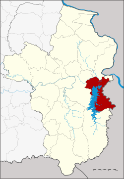
Amphoe Sirindhorn ( Thai อำเภอ สิริ น ธร , RTGS Sirinthon ) is a district ( Amphoe - administrative district) in the northwest of the province of Ubon Ratchathani . The province of Ubon Ratchathani is located in the northeast region of Thailand , the so-called Isan .
The name Sirindhorn was given to the district in honor of Princess Sirindhorn on her 36th birthday.
geography
Neighboring counties (clockwise from the south): the Amphoe Buntharik , Phibun Mangsahan and Khong Chiam of Ubon Ratchathani Province. To the east on the other bank of the Mekong lies the Laotian province of Champasak .
The Sirindhorn dam is in the district. It dams the Lam Dom Noi ( ลำ โดม น อย ) river.
traffic
There is an official border crossing to Laos:
- Chong Mek via Thailand Route 217 and further via National Road 16 to the Laotian city of Pakse (Pakxé) .
history
The district Sirindhorn was established on January 3, 1992, by tambon Kham Khuean Kaeo from Khong Chiam District and the five Tambon Khan Rai, Chong Mek, Nikhom Sang Ton-eng Lam Dom Noi, Non Ko and Fang Kham from Phibun Mangsahan District were separated .
Administrative units
Provincial Administration
The district of Sirindhorn is divided into six tambon ("sub-districts" or "municipalities"), which are further subdivided into 76 muban ("villages").
| No. | Surname | Thai | Muban | Pop. |
|---|---|---|---|---|
| 1. | Khan Rai | คัน ไร่ | 16 | 11,369 |
| 2. | Chong Mek | ช่อง เม็ก | 13 | 9,239 |
| 3. | Non Ko | โนน ก่อ | 14th | 10,435 |
| 4th | Nikhom Sang Ton-eng Lam Dom Noi | นิคมสร้างตนเอง ลำ โดม น้อย | 13 | 7,447 |
| 5. | Fang Kham | ฝาง คำ | 4th | 3,564 |
| 6th | Kham Khuean Kaeo | คำเขื่อนแก้ว | 16 | 10,353 |
Local administration
There are two municipalities with "small town" status ( Thesaban Tambon ) in the district:
- Chong Mek (Thai: เทศบาล ตำบล ช่อง เม็ก ) consists of parts of the Tambon Chong Mek.
- Nikhom Sang Ton-eng Lam Dom Noi (Thai: เทศบาล ตำบล นิคมสร้างตนเอง ลำ โดม น้อย ) consists of the entire Tambon Nikhom Sang Ton-eng Lam Dom Noi.
There are also five " Tambon Administrative Organizations " ( องค์การ บริหาร ส่วน ตำบล - Tambon Administrative Organizations, TAO):
- Khan Rai (Thai: องค์การ บริหาร ส่วน ตำบล คัน ไร่ )
- Chong Mek (Thai: องค์การ บริหาร ส่วน ตำบล ช่อง เม็ก )
- Non Ko (Thai: องค์การ บริหาร ส่วน ตำบล โนน ก่อ )
- Fang Kham (Thai: องค์การ บริหาร ส่วน ตำบล ฝาง คำ )
- Kham Khuean Kaeo (Thai: องค์การ บริหาร ส่วน ตำบล คำเขื่อนแก้ว )
Individual evidence
- ↑ พระราชกฤษฎีกา ตั้ง อำเภอ สิริ น ธร พ.ศ. ๒๕๓๔ Royal Gazette, Volume 108, Ed. 211 ก ฉบับ พิเศษ (special) from December 4, 1991, pp. 29–31 (in Thai)
- ↑ 2013 population statistics ( Thai ) Department of Provincial Administration. Retrieved August 4, 2014.
Web links
- More information about the Amphoe Sirindhorn at amphoe.com (in Thai)
- History and general map of Sirindhorn at ubonratchathani.go.th (in Thai)
- Amphoe Administration website (in Thai)
Coordinates: 15 ° 12 ' N , 105 ° 24' E

