Amphoe Khong Chiam
|
Khong Chiam โขงเจียม |
|
|---|---|
| Province: | Ubon Ratchathani |
| Surface: | 765.0 km² |
| Residents: | 35,749 (2013) |
| Population density : | 32.7 U / km² |
| ZIP : | 34220 |
| Geocode : | 3403 |
| map | |

|
|
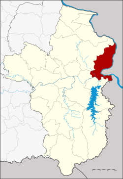
Amphoe Khong Chiam ( Thai : อำเภอ โขงเจียม ) is a district ( Amphoe - administrative district) in the east of the province of Ubon Ratchathani on the border with Laos . The province of Ubon Ratchathani is located in the northeast region of Thailand , the so-called Isan .
geography
Neighboring counties (clockwise from south): the Sirindhorn Amphoe , Phibun Mangsahan and Si Mueang Mai of Ubon Ratchathani Province. To the east on the other bank of the Mekong are the Lao provinces of Salavan and Champasak .
The controversial Pak Mun dam is in the district. It damms the Mae Nam Mun (Mun River) just before it flows into the Mekong .
history
Khong Chiam used to be the central district ( Khwaeng ) of the city ( Mueang ) Khong Chiam. On January 1, 1957, the three tambon Khong Chiam, Huai Yang and Pho Klang were separated from Khong Chiam to create the "branch circle" ( King Amphoe ) Ban Dan. Ban Dan got full amphoe status on December 11, 1959.
Since the historical center of the Mueang Khong Chiam was here, Ban Dan was renamed Khong Chiam on September 14, 1971, while the previous Khong Chiam district was renamed Si Mueang Mai.
Attractions
-
National parks :
- Kaeng Tana National Park - The 80 km² park was opened on July 13, 1981 as Thailand's 31st National Park . It covers the area south of the confluence of the Mun and Mekong rivers down to the Lao border. Sights are high cliffs with views of the Mekong and Laos, the Tana rapids in the Mun and several waterfalls.
- Pha Taem National Park - The 140 km² park was opened on December 31, 1991. It is located about 20 km north of the district capital along the western bank of the Mekong. The Pha Taem cliff, which allows a wide view of the Mekong, is worth seeing. On the rock walls of the cliff there are prehistoric rock carvings, the age of which is estimated to be 3,000-4,000 years.
Administrative units
Provincial Administration
The district of Khong Chiam is divided into five tambon ("subdistricts" or "parishes"), which are further subdivided into 52 muban ("villages").
| No. | Surname | Thai | Muban | Pop. |
|---|---|---|---|---|
| 1. | Khong Chiam | โขงเจียม | 12 | 8,789 |
| 2. | Huai Yang | ห้วย ยาง | 11 | 8,291 |
| 3. | Well Pho sound | นา โพธิ์ กลาง | 10 | 7,679 |
| 4th | Nong Saeng Yai | หนอง แสง ใหญ่ | 9 | 5,448 |
| 5. | Huai Phai | ห้วย ไผ่ | 10 | 5,542 |
Local administration
There is one municipality with "small town" status ( Thesaban Tambon ) in the district:
- Ban Dan Khong Chiam (Thai: เทศบาล ตำบล บ้าน ด่าน โขงเจียม ), consisting of parts of the Tambon Khong Chiam.
There are also five " Tambon Administrative Organizations " ( องค์การ บริหาร ส่วน ตำบล - Tambon Administrative Organizations, TAO):
- Khong Chiam (Thai: องค์การ บริหาร ส่วน ตำบล โขงเจียม )
- Huai Yang (Thai: องค์การ บริหาร ส่วน ตำบล ห้วย ยาง )
- Na Pho Klang (Thai: องค์การ บริหาร ส่วน ตำบล นา โพธิ์ กลาง )
- Nong Saeng Yai (Thai: องค์การ บริหาร ส่วน ตำบล หนอง แสง ใหญ่ )
- Huai Phai (Thai: องค์การ บริหาร ส่วน ตำบล ห้วย ไผ่ )
Individual evidence
- ↑ ประกาศ กระทรวง มหาดไทย เรื่อง ย้าย ที่ว่าการ อำเภอ โขงเจียม และ ตั้ง กิ่ง อำเภอ บ้าน ด่าน จังหวัด อุบลราชธานี Royal Gazette, Volume 74, Issue 8 ง of January 22, 1957, pp. 225-226 (in Thai)
- ↑ พระราชกฤษฎีกา ตั้ง อำเภอ ชุมพวง อำเภอ เชียงยืน อำเภอ แก้ง ค ร้ อ อำเภอ สำโรงทาบ อำเภอ คอน สาร อำเภอ เซกา อำเภอ ทุ่งเสลี่ยม อำเภอ บ้าน ด่าน ด่าน อำเภอ ขนอม อำเภอ บ้านแพรก อำเภอ กระทู้ และ อำเภอ คลองใหญ่ พ.ศ. ๒๕๐๒ Royal Gazette, Volume 76, Ed. 113 ก special ( ฉบับ พิเศษ ) of December 10, 1959, pp. 8–11 (in Thai)
- ↑ พระราชกฤษฎีกา เปลี่ยน ชื่อ อำเภอ บาง แห่ง ใน จังหวัด อุบลราชธานี พ.ศ. ๒๕๑๔ Royal Gazette, Volume 88, Ed. 98 ก September 14, 1971, pp. 618–620 (in Thai)
- ↑ 2013 population statistics ( Thai ) Department of Provincial Administration. Retrieved August 4, 2014.
Web links
- More information about Khong Chiam at amphoe.com (in Thai)
- Amphoe Administration website (in Thai)
- Information on the Kaeng Tana National Park from dnp.go.th (in English)
- Information about the Pha Taem National Park from dnp.go.th (in English)
Coordinates: 15 ° 19 ′ N , 105 ° 30 ′ E


