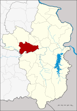
Amphoe Mueang Ubon Ratchathani
|
Mueang Ubon Ratchathani เมือง อุบลราชธานี |
|
|---|---|
| Province: | Ubon Ratchathani |
| Surface: | 406.4 km² |
| Residents: | 219,262 (2013) |
| Population density : | 521.3 U / km² |
| ZIP : | 34000 |
| Geocode : | 3401 |
| map | |

|
|
Amphoe Mueang Ubon Ratchathani ( Thai อำเภอ เมือง อุบลราชธานี ) is a district ( Amphoe - Administrative District) in the Province of Ubon Ratchathani . The province of Ubon Ratchathani is located in the northeast region of Thailand , the so-called Isan .
geography
Ubon is located in the triangle of Thailand, Laos and Cambodia , about 630 kilometers northeast of the capital Bangkok . The Mae Nam Mun (Mun River) , the largest river in the Isan, flows through the district .
Neighboring districts (clockwise from west): Khueang Nai Muang Sam Sip , Lao Suea Kok , Don Mot Daeng , Sawang Wirawong , and Warin Chamrap of Ubon Ratchathani Province and Kanthararom District of Si Sa Ket Province .
The most important water resource is the Mae Nam Mun (Mun River) .
history
The county was originally called Buphapala Nikhom ( บุพ ป ล นิคม ). The name was changed to Burapha Ubon ( บูรพา อุบล ) in 1909 , to Amphoe Mueang Ubon in 1913 and to Amphoe Mueang Ubon Ratchathani on April 24, 1917.
traffic
Ubon Ratchathani Airport is located in this district .
education
The Rajabhat University of Ubon Ratchathani is located in Amphoe Mueang Ubon Ratchathani .
administration
Provincial Administration
The county of Mueang Ubon Ratchathani is divided into twelve tambon ("subdistricts" or "parishes"), which are further subdivided into 157 muban ("villages").
| No. | Surname | Thai | Muban | Pop. |
|---|---|---|---|---|
| 1. | Nai Mueang | ใน เมือง | - | 79,797 |
| 4th | Hua Ruea | หัว เรือ | 16 | 9.124 |
| 5. | Nong Khon | หนอง ขอน | 15th | 9,256 |
| 7th | Pathum | ปทุม | 14th | 10,499 |
| 8th. | Kham Yai | ขาม ใหญ่ | 26th | 37,717 |
| 9. | Chaeramae | แจ ระ แม | 10 | 13,267 |
| 11. | Nong Bo | หนอง บ่อ | 13 | 7,651 |
| 12. | Rai Noi | ไร่ น้อย | 19th | 22,936 |
| 13. | Krasop | กระ โส บ | 11 | 6.117 |
| 16. | Ku Talat | กุด ลาด | 14th | 11,130 |
| 19th | Khilek | ขี้เหล็ก | 11 | 6,423 |
| 20th | Pa-ao | ปะ อาว | 8th | 5,345 |
Note: the missing numbers (geocodes) refer to the tambon that are now in the Don Mot Daeng and Lao Suea Kok districts.
Local administration
There is one commune with "big city" status ( Thesaban Nakhon ) in the county:
- Ubon Ratchathani (Thai: เทศบาล นคร อุบลราชธานี ) comprises the entire Tambon Nai Mueang.
There is one commune with "city" status ( Thesaban Mueang ) in the district:
- Chaeramae (Thai: เทศบาล เมือง แจ ระ แม ) consists of parts of the Tambon Chaeramae.
There are three municipalities with "small town" status ( Thesaban Tambon ) in the district:
- Ubon (Thai: เทศบาล ตำบล อุบล ) consists of parts of the Tambon Kham Yai and Chaeramae.
- Kham Yai (Thai: เทศบาล ตำบล ขาม ใหญ่ ) consists of the remaining parts of the Tambon Kham Yai.
- Pathum (Thai: เทศบาล ตำบล ปทุม ) consists of the entire Tambon Pathum.
There are also eight " Tambon Administrative Organizations " ( องค์การ บริหาร ส่วน ตำบล - Tambon Administrative Organizations, TAO):
- Hua Ruea (Thai: องค์การ บริหาร ส่วน ตำบล หัว เรือ )
- Nong Khon (Thai: องค์การ บริหาร ส่วน ตำบล หนอง ขอน )
- Nong Bo (Thai: องค์การ บริหาร ส่วน ตำบล หนอง บ่อ )
- Rai Noi (Thai: องค์การ บริหาร ส่วน ตำบล ไร่ น้อย )
- Krasop (Thai: องค์การ บริหารส่วน ตำบล กระ โส บ )
- Ku Talat (Thai: องค์การ บริหาร ส่วน ตำบล กุด ลาด )
- Khilek (Thai: องค์การ บริหาร ส่วน ตำบล ขี้เหล็ก )
- Pa-ao (Thai: องค์การ บริหาร ส่วน ตำบล ปะ อาว )
Individual evidence
- ↑ History of the district of Amphoe Mueang Ubon Ratchathani ( Memento of the original from January 18, 2016 in the Internet Archive ) Info: The archive link was inserted automatically and has not yet been checked. Please check the original and archive link according to the instructions and then remove this notice.
- ↑ แจ้ง ความ กระทรวง มหาดไทย เรื่อง เปลี่ยน นาม อำเภอ . In: Royal Gazette . 30, No. 0 ง , October 12, 1913, pp. 1536–1537.
- ↑ 2013 population statistics ( Thai ) Department of Provincial Administration. Retrieved August 3, 2014.
Web links
- More details on Amphoe Mueang Ubon Ratchathani from amphoe.com (in Thai)
- Amphoe Administration website (in Thai)
Coordinates: 15 ° 14 ' N , 104 ° 52' E
