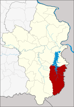
Amphoe Buntharik
|
Buntharik บุณฑริก |
|
|---|---|
| Province: | Ubon Ratchathani |
| Surface: | 1402.0 km² |
| Residents: | 91,649 (2013) |
| Population density : | 62.8 U / km² |
| ZIP : | 34230 |
| Geocode : | 3410 |
| map | |

|
|
Amphoe Buntharik ( Thai : อำเภอ บุณฑริก ) is a district ( Amphoe - administrative district) in the southeast of the Ubon Ratchathani Province . The province of Ubon Ratchathani is located in the northeast region of Thailand , the so-called Isan .
geography
Buntharik district borders on the following counties (clockwise from the west): Na Chaluai , Det Udom , Phibun Mangsahan and Sirindhorn district in Ubon Ratchathani Province and Champasak Province of Laos .
The county’s most important water resource is the Lam Dom Noi ( ลำ โดม น อย ) River .
history
Buntharik was first established in 1923 as a "branch circle" ( King Amphoe ) , the center of which was in Ban Phon Ngam on the eastern bank of Lam Dom Noi . Later the district was called Phon Ngam. In 1939 the name was changed back to Buntharik. On July 22, 1958, Buntharik was promoted to Amphoe.
Administrative units
Provincial Administration
The district of Buntharik is divided into eight tambon ("sub-districts" or "municipalities"), which are further subdivided into 126 muban ("villages").
| No. | Surname | Thai | Muban | Pop. |
|---|---|---|---|---|
| 1. | Phon Ngam | โพน งาม | 14th | 12,161 |
| 2. | Huai Kha | ห้วย ข่า | 23 | 16,743 |
| 3. | Kho Laen | คอแลน | 18th | 12,630 |
| 4th | Well Pho | นา โพธิ์ | 11 | 8,677 |
| 5. | Nong Sano | หนอง สะ โน | 23 | 16,553 |
| 6th | Non Kho | โนน ค้อ | 11 | 6,739 |
| 7th | Bua Ngam | บัว งาม | 15th | 10.137 |
| 8th. | Ban Maet | บ้าน แม ด | 11 | 8.009 |
Local administration
There are three municipalities with "small town" status ( Thesaban Tambon ) in the district:
- Na Pho (Thai: เทศบาล ตำบล นา โพธิ์ ), consisting of the entire Tambon Na Pho.
- Buntharik (Thai: เทศบาล ตำบล บุณฑริก ), consisting of parts of the Tambon Bua Ngam and Phon Ngam.
- Kho Laen (Thai: เทศบาล ตำบล คอแลน ) Kho Laen.
There are also six " Tambon Administrative Organizations " ( องค์การ บริหาร ส่วน ตำบล - Tambon Administrative Organizations, TAO):
- Phon Ngam (Thai: องค์การ บริหาร ส่วน ตำบล โพน งาม )
- Huai Kha (Thai: องค์การ บริหาร ส่วน ตำบล ห้วย ข่า )
- Nong Sano (Thai: องค์การ บริหาร ส่วน ตำบล หนอง สะ โน )
- Non Kho (Thai: องค์การ บริหาร ส่วน ตำบล โนน ค้อ )
- Bua Ngam (Thai: องค์การ บริหาร ส่วน ตำบล บัว งาม )
- Ban Maet (Thai: องค์การ บริหารส่วน ตำบล บ้าน แม ด )
Individual evidence
- ↑ พระราชกฤษฎีกา เปลี่ยน นาม อำเภอ กิ่ง อำเภอ และ ตำบล บาง แห่ง พุทธศักราช ๒๔๘๒ . In: Royal Gazette . 56, No. 0 ก , April 17, 1939, pp. 354-364.
- ↑ พระราชกฤษฎีกา จัดตั้ง อำเภอ กระสัง ... . In: Royal Gazette . 75, No. 55 ก , July 22, 1958, pp. 321-327.
- ↑ 2013 population statistics ( Thai ) Department of Provincial Administration. Retrieved August 4, 2014.
Web links
- More information about the Amphoe Buntharik at amphoe.com (in Thai)
- Amphoe Administration website (in Thai)
Coordinates: 14 ° 45 ' N , 105 ° 25' E
