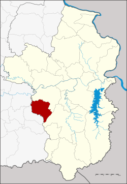
Amphoe Samrong
|
Samrong สำโรง |
|
|---|---|
| Province: | Ubon Ratchathani |
| Surface: | 416.0 km² |
| Residents: | 53,555 (2013) |
| Population density : | 124.9 U / km² |
| ZIP : | 34360 |
| Geocode : | 3422 |
| map | |

|
|
Amphoe Samrong ( Thai : สำโรง ) is a district ( Amphoe - administrative district) in the west of Ubon Ratchathani Province . The province of Ubon Ratchathani is located in the northeast region of Thailand , the so-called Isan .
geography
Neighboring counties (clockwise from the north): the Amphoe Warin Chamrap and Det Udom of the province of Ubon Ratchathani, and the Amphoe Non Khun and Kanthararom of the province of Si Sa Ket .
history
Samrong County was set up on April 15, 1985 as a “branch circle” ( King Amphoe ) by separating the six Tambon Samrong, Khok Kong, Nong Hai, Kho Noi, Non Ka Len and Khok Sawang from the Warin Chamrap district . On May 9, 1992, Samrong was granted full amphoe status.
Administrative units
Provincial Administration
Samrong County is divided into nine tambon ("subdistricts" or "communities"), which are further subdivided into 108 muban ("villages").
| No. | Surname | Thai | Muban | Pop. |
|---|---|---|---|---|
| 1. | Samrong | สำโรง | 12 | 7.134 |
| 2. | Khok Kong | โคก ก่อง | 17th | 6.119 |
| 3. | Nong Hai | หนอง ไฮ | 12 | 6.333 |
| 4th | Kho Noi | ค้อ น้อย | 17th | 7,718 |
| 5. | Non Ka Len | โนน กา เล็น | 12 | 7,795 |
| 6th | Khok Sawang | โคก สว่าง | 12 | 7,955 |
| 7th | Non sound | โนน กลาง | 10 | 4,470 |
| 8th. | Receipt | บอน | 7th | 3,317 |
| 9. | Kham Pom | ขาม ป้อม | 9 | 2.714 |
Local administration
There is one municipality with "small town" status ( Thesaban Tambon ) in the district:
- Samrong (Thai: เทศบาล ตำบล สำโรง ), consisting of the entire tambon Samrong.
There are also eight " Tambon Administrative Organizations " ( องค์การ บริหาร ส่วน ตำบล - Tambon Administrative Organizations, TAO):
- Khok Kong (Thai: องค์การ บริหาร ส่วน ตำบล โคก ก่อง )
- Nong Hai (Thai: องค์การ บริหาร ส่วน ตำบล หนอง ไฮ )
- Kho Noi (Thai: องค์การ บริหาร ส่วน ตำบล ค้อ น้อย )
- Non Ka Len (Thai: องค์การ บริหาร ส่วน ตำบล โนน กา เล็น )
- Khok Sawang (Thai: องค์การ บริหาร ส่วน ตำบล โคก สว่าง )
- Non Klang (Thai: องค์การ บริหาร ส่วน ตำบล โนน กลาง )
- Bon (Thai: องค์การ บริหาร ส่วน ตำบล บอน )
- Kham Pom (Thai: องค์การ บริหาร ส่วน ตำบล ขาม ป้อม )
Individual evidence
- ↑ ประกาศ กระทรวง มหาดไทย เรื่อง แบ่ง เขต ท้องที่ อำเภอ วารินชำราบ จังหวัด อุบลราชธานี ตั้ง เป็น กิ่ง อำเภอ สำโรง Royal Gazette Volume 102, Ed. 47 ง of April 16, 1985, p. 1842 (in Thai)
- ↑ พระราชกฤษฎีกา ตั้ง อำเภอ สอยดาว อำเภอ โพน สวรรค์ อำเภอ บาง ขัน อำเภอ หว้า น ใหญ่ อำเภอ เมือง ปาน อำเภอ ภู หลวง อำเภอ โคก ศรีสุพรรณ และ อำเภอ สำโรง พ.ศ. ๒๕๓๕ Royal Gazette Volume 109, Ed. 45 ก April 9, 1992, pp. 27-29 (in Thai)
- ↑ 2013 population statistics ( Thai ) Department of Provincial Administration. Retrieved August 4, 2014.
Web links
- More information on Amphoe Samrong from amphoe.com (in Thai)
- Amphoe Administration website (in Thai)
Coordinates: 15 ° 0 ' N , 104 ° 47' E
