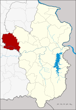
Khueang Nai district
|
Khueang Nai เขื่องใน |
|
|---|---|
| Province: | Ubon Ratchathani |
| Surface: | 772.8 km² |
| Residents: | 108,352 (2013) |
| Population density : | 141.6 U / km² |
| ZIP : | 34150, 34320 |
| Geocode : | 3404 |
| map | |

|
|
Amphoe Khueang Nai ( Thai : เขื่องใน ) is a district ( Amphoe - administrative district) in the northwest of the Ubon Ratchathani Province . The province of Ubon Ratchathani is located in the northeast region of Thailand , the so-called Isan .
geography
Neighboring districts are (from the east clockwise): Amphoe Muang Sam Sip , Mueang Ubon Ratchathani Ubon Ratchathani province, the Amphoe Kanthararom and Yang Chum Noi the province of Si Sa Ket , Amphoe Kho Wang , Maha Chana Chai , Kham Khuean Kaeo the province Yasothon and Amphoe Hua Taphan in the province of Amnat Charoen .
history
The district was originally called Pachin Ubon ( ป จิ ม อุบล , West Ubon), in 1913 it was renamed Trakan Phuet Phon ( ตระการพืชผล ). In 1917 the name was changed again, this time to Khueang Nai.
Administrative units
Provincial Administration
Khueang Nai County is divided into 18 tambon ("subdistricts" or "parishes"), which are further divided into 182 muban ("villages").
| No. | Surname | Thai | Muban | Pop. |
|---|---|---|---|---|
| 1. | Khueang Nai | เขื่องใน | 12 | 10.186 |
| 2. | Sang Tho | สร้าง ถ่อ | 16 | 9,543 |
| 3. | Kho Thong | ค้อ ทอง | 11 | 6.324 |
| 4th | Ko E | ก่อ เอ้ | 12 | 7,399 |
| 5. | Hua Don | หัว ดอน | 11 | 6,473 |
| 6th | Chi Thuan | ชีท วน | 11 | 6,545 |
| 7th | Tha Hai | ท่า ไห | 13 | 8,933 |
| 8th. | Na Kham Yai | นา คำ ใหญ่ | 8th | 3,863 |
| 9. | Daeng Mo | แดง หม้อ | 6th | 3,257 |
| 10. | That noi | ธาตุ น้อย | 10 | 6.374 |
| 11. | Ban Thai | บ้าน ไทย | 12 | 6,481 |
| 12. | Ban Kok | บ้าน กอก | 6th | 3,980 |
| 13. | Sounded yai | กลาง ใหญ่ | 11 | 5,380 |
| 14th | Non rank | โนน รัง | 7th | 4,392 |
| 15th | Yang Khi Nok | ยาง ขี้นก | 10 | 4,868 |
| 16. | Si Suk | ศรีสุข | 8th | 5,378 |
| 17th | Sahathat | สห ธาตุ | 7th | 3,088 |
| 18th | Nong Lao | หนอง เหล่า | 11 | 5,888 |
Local administration
There are 3 municipalities with "small town" status ( Thesaban Tambon ) in the district:
- Huai Ruea (Thai: เทศบาล ตำบล ห้วย เรือ ), consisting of parts of the Tambon Khueang Nai.
- Ban Kok (Thai: เทศบาล ตำบล บ้าน กอก ), consisting of the entire tambon Ban Kok.
- Khueang Nai (Thai: เทศบาล ตำบล เขื่องใน ), consisting of the entire tambon Khueang Nai.
There are also 16 " Tambon Administrative Organizations " ( องค์การ บริหาร ส่วน ตำบล - Tambon Administrative Organizations, TAO):
- Sang Tho (Thai: องค์การ บริหาร ส่วน ตำบล สร้าง ถ่อ )
- Kho Thong (Thai: องค์การ บริหาร ส่วน ตำบล ค้อ ทอง )
- Ko E (Thai: องค์การ บริหาร ส่วน ตำบล ก่อ เอ้ )
- Hua Don (Thai: องค์การ บริหาร ส่วน ตำบล หัว ดอน )
- Chi Thuan (Thai: องค์การ บริหาร ส่วน ตำบล ชีท วน )
- Tha Hai (Thai: องค์การ บริหาร ส่วน ตำบล ท่า ไห )
- Na Kham Yai (Thai: องค์การ บริหาร ส่วน ตำบล นา คำ ใหญ่ )
- Daeng Mo (Thai: องค์การ บริหาร ส่วน ตำบล แดง หม้อ )
- That Noi (Thai: องค์การ บริหาร ส่วน ตำบล ธาตุ น้อย )
- Ban Thai (Thai: องค์การ บริหาร ส่วน ตำบล บ้าน ไทย )
- Klang Yai (Thai: องค์การ บริหาร ส่วน ตำบล กลาง ใหญ่ )
- Non Rang (Thai: องค์การ บริหาร ส่วน ตำบล โนน รัง )
- Yang Khi Nok (Thai: องค์การ บริหาร ส่วน ตำบล ยาง ขี้นก )
- Si Suk (Thai: องค์การ บริหาร ส่วน ตำบล ศรีสุข )
- Sahathat (Thai: องค์การ บริหาร ส่วน ตำบล สห ธาตุ )
- Nong Lao (Thai: องค์การ บริหาร ส่วน ตำบล หนอง เหล่า )
Individual evidence
- ↑ แจ้ง ความ กระทรวง มหาดไทย เรื่อง เปลี่ยน นาม อำเภอ . In: Royal Gazette . 30, No. 0 ง , October 12, 1913, pp. 1536–1537.
- ↑ ประกาศ กระทรวง มหาดไทย เรื่อง เปลี่ยน ชื่อ อำเภอ . In: Royal Gazette . 34, No. 0 ก , April 29, 1917, pp. 40-68.
- ↑ 2013 population statistics ( Thai ) Department of Provincial Administration. Retrieved August 4, 2014.
Web links
- More information about Amphoe Khueang Nai at amphoe.com (in Thai)
- Amphoe Administration website (in Thai)
Coordinates: 15 ° 23 ' N , 104 ° 33' E
