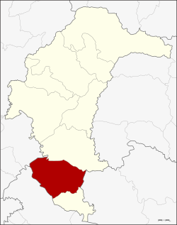
Maha Chana Chai district
|
Maha Chana Chai มหาชนะชัย |
|
|---|---|
| Province: | Yasothon |
| Surface: | 455.27 km² |
| Residents: | 57,633 (2013) |
| Population density : | 128.9 U / km² |
| ZIP : | 35130 |
| Geocode : | 3506 |
| map | |

|
|
Amphoe Maha Chana Chai (in Thai อำเภอ มหาชนะชัย ) is a district ( Amphoe - Administrative District) in the Yasothon Province . The province of Yasothon is located in the eastern part of the northeast region of Thailand , the so-called Isan .
geography
Maha Chana Chai District borders the following districts (from north clockwise as seen) at Amphoe Kham Khuean Kaeo province Yasothon to Amphoe Khueang Nai the province of Ubon Ratchathani , at Amphoe Kho Wang again in Yasothon to Amphoe Rasi Salai and Sila Lat in the province of Si Sa Ket , and at Amphoe Phanom Phrai in the province of Roi Et .
history
The place Maha Chana Chai was formerly called Han Chai Chana ( หัน ชัน ชนะ ), which was founded in 1859 by Prince Thao Puttakhamphun ( ท้าว ปุตตะ คำ พูน ราชบุตร ). In 1863 King Mongkut (Rama IV.) Renamed the place Mueang Maha Chana Chai.
In 1909, the place became an amphoe of Ubon Ratchathani Province, and on April 24, 1917, its name was changed to Fa Yat ( อำเภอ ฟ้า หยาด ) because its administration was in Fa Yat Village. On April 7, 1939, the name was changed back to Amphoe Maha Chana Chai.
When the new Yasothon Province was established on March 1, 1972, Maha Chan Chai was one of the six districts that originally made up the new province.
administration
Provincial Administration
The district of Maha Chana Chai is divided into ten tambon ("sub-districts" or "parishes"), which are further subdivided into 103 muban ("villages").
| No. | Surname | Thai | Muban | Pop. |
|---|---|---|---|---|
| 1. | Fa Yat | ฟ้า หยาด | 10 | 10.102 |
| 2. | Hua Mueang | หัวเมือง | - | 7,447 |
| 3. | Khu Mueang | คูเมือง | - | 6,661 |
| 4th | Phue Hi | ผื อ ฮี | - | 4,325 |
| 5. | Bak Ruea | บาก เรือ | 11 | 4,729 |
| 6th | Muang | ม่วง | - | 6,440 |
| 7th | Non Sai | โนน ทราย | 7th | 3,086 |
| 8th. | Bueng Kae | บึง แก | - | 5,586 |
| 9. | Phra Sao | พระ เสาร์ | 10 | 4,314 |
| 10. | Song Yang | สง ยาง | - | 4,943 |
Note: Some of the Muban's data are not yet available.
Local administration
There is one municipality with "small town" status ( Thesaban Tambon ) in the district:
- Fa Yat (Thai: เทศบาล ตำบล ฟ้า หยาด ), consisting of parts of the tambon Fa Yat.
There are also ten " Tambon Administrative Organizations " ( องค์การ บริหาร ส่วน ตำบล - Tambon Administrative Organizations, TAO):
- Fa Yat (Thai: องค์การ บริหาร ส่วน ตำบล ฟ้า หยาด )
- Hua Mueang (Thai: องค์การ บริหาร ส่วน ตำบล หัวเมือง )
- Khu Mueang (Thai: องค์การ บริหาร ส่วน ตำบล คูเมือง )
- Phue Hi (Thai: องค์การ บริหาร ส่วน ตำบล ผื อ ฮี )
- Bak Ruea (Thai: องค์การ บริหาร ส่วน ตำบล บาก เรือ )
- Muang (Thai: องค์การ บริหาร ส่วน ตำบล ม่วง )
- Non Sai (Thai: องค์การ บริหาร ส่วน ตำบล โนน ทราย )
- Bueng Kae (Thai: องค์การ บริหาร ส่วน ตำบล บึง แก )
- Phra Sao (Thai: องค์การ บริหาร ส่วน ตำบล พระ เสาร์ )
- Song Yang (Thai: องค์การ บริหาร ส่วน ตำบล สง ยาง )
Individual evidence
- ↑ ประกาศ กระทรวง มหาดไทย เรื่อง เปลี่ยน ชื่อ อำเภอ . In: Royal Gazette . 34, No. 0 ก , April 29, 1917, pp. 40-68.
- ↑ พระราชกฤษฎีกา เปลี่ยน นาม อำเภอ กิ่ง อำเภอ และ ตำบล บาง แห่ง พุทธศักราช ๒๔๘๒ . In: Royal Gazette . 56, No. 0 ก , April 17, 1939, pp. 354-364.
- ↑ 2013 population statistics ( Thai ) Department of Provincial Administration. Retrieved August 4, 2014.
Web links
Coordinates: 15 ° 32 ' N , 104 ° 15' E