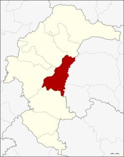
Amphoe Pa Tio
|
Pa Tio ป่าติ้ว |
|
|---|---|
| Province: | Yasothon |
| Surface: | 308.0 km² |
| Residents: | 35,223 (2013) |
| Population density : | 114.9 U / km² |
| ZIP : | 35150 |
| Geocode : | 3505 |
| map | |

|
|
Amphoe Pa Tio (in Thai อำเภอ ป่าติ้ว ) is a district ( amphoe - administrative district) in Yasothon Province . The province of Yasothon is located in the eastern part of the northeast region of Thailand , the so-called Isan .
geography
Amphoe Pa Tio borders the following districts (clockwise from the south): Amphoe Kham Khuean Kaeo , Mueang Yasothon , Kut Chum and Thai Charoen in Yasothon Province, and Amphoe Mueang Amnat Charoen and Hua Taphan in Amnat Charoen Province .
history
When large parts of Siam east of the Mekong fell to France at the end of the 19th century , there were numerous settlers from Laos who wanted to settle in the Isan. Ban Pa Tio was also among the newly established villages. In 1933 the Thai “Highway Department” built a road from the Amphoe Yasothon to the Amphoe Amnat Charoen and Amphoe Khemarat, the three districts of the then Ubon Ratchathani Province . This road also ran through the village of Pa Tio, which helped it grow. In 1951 a petition was filed to promote Pa Tio to a "branch circle" ( King Amphoe ) with the three tambon Pho Sai, Krachai and Khok Na Ko. However, this was not officially complied with until August 17, 1966.
In 1969, Pa Tio was granted Amphoe status in the Ubon Ratchathani Province. When Yasothon became an independent province on March 1, 1972, Pa Tio was one of the six districts that were assigned to the new province.
administration
Provincial Administration
Amphoe Pa Tio is divided into five communities ( Tambon ) , which in turn are divided into 57 villages ( Muban ) .
| No. | Surname | Thai | Villages | Pop. |
|---|---|---|---|---|
| 1. | Pho Sai | โพธิ์ ไทร | 12 | 9,482 |
| 2. | Krachai | กระจาย | 13 | 7,607 |
| 3. | Khok Na Ko | โคก นา โก | 16 | 8,365 |
| 4th | Chiang Pheng | เชียง เพ็ง | 7th | 3,545 |
| 5. | Si than | ศรี ฐาน | 8th | 6.224 |
Local administration
There is one municipality with "small town" status ( Thesaban Tambon ) in the district:
- Pa Tio (Thai: เทศบาล ตำบล ป่าติ้ว ), consisting of parts of the Tambon Pho Sai.
There are also five " Tambon Administrative Organizations " ( องค์การ บริหาร ส่วน ตำบล - Tambon Administrative Organizations, TAO) in the district.
Individual evidence
- ↑ ประกาศ กระทรวง มหาดไทย เรื่อง แบ่ง ท้องที่ ตั้ง เป็น กิ่ง อำเภอ . In: Royal Gazette . 83, No. 74 ง ฉบับ พิเศษ (special), September 1, 1966, p. 6.
- ↑ พระราชกฤษฎีกา จัดตั้ง อำเภอ สมเด็จ อำเภอ สีชมพู อำเภอ หนองบัวแดง อำเภอ บ้านแท่น อำเภอ ดอนตูม อำเภอ นากลาง อำเภอ ศรีบุญเรือง และ อำเภอ ป่าติ้ว พ.ศ. ๒๕๑๒ . In: Royal Gazette . 86, No. 16 ก , February 25, 1969, pp. 225-229.
- ↑ 2013 population statistics ( Thai ) Department of Provincial Administration. Retrieved August 4, 2014.
Web links
Coordinates: 15 ° 50 ' N , 104 ° 23' E