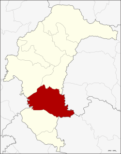
Amphoe Kham Khuean Kaeo
|
Kham Khuean Kaeo คำเขื่อนแก้ว |
|
|---|---|
| Province: | Yasothon |
| Surface: | 638.4 km² |
| Residents: | 67,699 (2013) |
| Population density : | 107.5 U / km² |
| ZIP : | 35110, 35180 |
| Geocode : | 3504 |
| map | |

|
|
Amphoe Kham Khuean Kaeo (in Thai อำเภอ คำเขื่อนแก้ว ) is a district ( amphoe - administrative district) in the province of Yasothon . The province of Yasothon is located in the eastern part of the northeast region of Thailand , the so-called Isan .
geography
Amphoe Kham Khuean Kaeo borders the following districts (from northwest clockwise): Amphoe Mueang Yasothon and Pa Tio in the province of Yasothon, Amphoe Hua Taphan in the province of Amnat Charoen , to Amphoe Khueang Nai in the province of Ubon Ratchathani , and to Amphoe Maha Chana Chai in turn in Yasothon, as well as in Amphoe Phanom Phrai in the province of Roi Et .
history
From 1917 to 1953 the district was called Lumphuk after the tambon in which the administration building is located. On November 4, 1953, the name was changed back to the original name Kham Khuean Kaeo. When Yasothon became an independent province, Kham Khuean Kaeo was one of the districts that were assigned to the new province.
administration
Provincial Administration
The county of Kham Khuean Kaeo is divided into 13 tambon ("subdistricts" or "parishes"), which are further subdivided into 115 muban ("villages").
| No. | Surname | Thai | Muban | Pop. |
|---|---|---|---|---|
| 1. | Lumphuk | ลุ ม พุก | - | 12,813 |
| 2. | Yo | ย่อ | - | 6,590 |
| 3. | Song Pueai | สง เปื อย | 9 | 4,337 |
| 4th | Phon Than | โพน ทัน | - | 3,390 |
| 5. | Thung Mon | ทุ่ง ม น | 9 | 6,051 |
| 6th | Well Kham | นา คำ | 6th | 2,681 |
| 7th | Dong Khaen Yai | ดง แคน ใหญ่ | 13 | 7,733 |
| 8th. | Ku Chan | กู่ จาน | 12 | 5,723 |
| 9. | Well Kae | นาแก | - | 3,626 |
| 10. | Kut Kung | กุด กุ ง | 7th | 4,638 |
| 11. | Lao shark | เหล่า ไฮ | - | 2,868 |
| 12. | Khaen Noi | แคน น้อย | - | 3,536 |
| 13. | Dong Charoen | ดง เจริญ | - | 3.713 |
Note: Some of the Muban's data are not yet available.
Local administration
There are two municipalities with "small town" status ( Thesaban Tambon ) in the district:
- Dong Khaen Yai (Thai: เทศบาล ตำบล ดง แคน ใหญ่ ), consisting of the whole tambon Dong Khaen Yai.
- Kham Khuean Kaeo (Thai: เทศบาล ตำบล คำเขื่อนแก้ว ), consisting of parts of the Tambon Lumphuk.
There are also twelve " Tambon Administrative Organizations " ( องค์การ บริหาร ส่วน ตำบล - Tambon Administrative Organizations, TAO):
- Lumphuk (Thai: องค์การ บริหารส่วน ตำบล ลุ ม พุก )
- Yo (Thai: องค์การ บริหาร ส่วน ตำบล ย่อ )
- Song Pueai (Thai: องค์การ บริหาร ส่วน ตำบล สง เปื อย )
- Phon Than (Thai: องค์การ บริหาร ส่วน ตำบล โพน ทัน )
- Thung Mon (Thai: องค์การ บริหาร ส่วน ตำบล ทุ่ง ม น )
- Na Kham (Thai: องค์การ บริหาร ส่วน ตำบล นา คำ )
- Ku Chan (Thai: องค์การ บริหาร ส่วน ตำบล กู่ จาน )
- Na Kae (Thai: องค์การ บริหาร ส่วน ตำบล นาแก )
- Kut Kung (Thai: องค์การ บริหาร ส่วน ตำบล กุด กุ ง )
- Lao Hai (Thai: องค์การ บริหาร ส่วน ตำบล เหล่า ไฮ )
- Khaen Noi (Thai: องค์การ บริหาร ส่วน ตำบล แคน น้อย )
- Dong Charoen (Thai: องค์การ บริหาร ส่วน ตำบล ดง เจริญ )
Individual evidence
- ↑ ประกาศ กระทรวง มหาดไทย เรื่อง เปลี่ยน ชื่อ อำเภอ . In: Royal Gazette . 34, No. 0 ก , April 29, 1917, pp. 40-68.
- ↑ พระราชกฤษฎีกา เปลี่ยน ชื่อ อำเภอ และ ตำบล บาง แห่ง พ.ศ. ๒๔๙๖ . In: Royal Gazette . 70, No. 25 ก , April 14, 1953, pp. 492-496.
- ↑ ประกาศ ของ คณะ ปฏิวัติ ฉบับ ที่ ๗๐ . In: Royal Gazette . 89, No. 21 ก ฉบับ พิเศษ , February 7, 1972, pp. 1-3.
- ↑ 2013 population statistics ( Thai ) Department of Provincial Administration. Retrieved August 4, 2014.
Web links
Coordinates: 15 ° 39 ′ N , 104 ° 19 ′ E