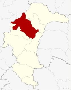
Amphoe Kut Chum
|
Kut Chum กุดชุม |
|
|---|---|
| Province: | Yasothon |
| Surface: | 544.0 km² |
| Residents: | 66,352 (2013) |
| Population density : | 121.25 U / km² |
| ZIP : | 35140 |
| Geocode : | 3503 |
| map | |

|
|
Amphoe Kut Chum (in Thai อำเภอ กุดชุม ) is a district ( amphoe - administrative district) in Yasothon Province . The province of Yasothon is located in the eastern part of the northeast region of Thailand , the so-called Isan .
geography
Neighboring districts (clockwise from the northeast): the Amphoe Loeng Nok Tha , Thai Charoen , Pa Tio , Mueang Yasothon and Sai Mun in the province of Yasothon, and to the Amphoe Selaphum and Nong Phok in the province of Roi Et .
history
The village of Kut Chum was established in 1912. A "branch circle" ( King Amphoe ) Kut Chum was established on August 1, 1961, by separating the four Tambon Non Pueai, Phai (which came to Amphoe Sai Mun in 1978), Phon Ngan and Kammaet from Amphoe Yasothon. On July 17, 1963, the minor district was promoted to Amphoe of Ubon Ratchathani Province. When the province of Yasothon was separated from Ubon Ratchathani and became an independent province, Kut Chum was one of the tambon that were assigned to the new province.
administration
Provincial Administration
The district of Kut Chum is divided into nine tambon ("subdistricts" or "municipalities"), which are further subdivided into 125 muban ("villages").
| No. | Surname | Thai | Muban | Pop. |
|---|---|---|---|---|
| 1. | Kut Chum | กุดชุม | 21st | 13.208 |
| 2. | Non pueai | โนน เปื อย | - | 7,072 |
| 3. | Kammaet | กำ แม ด | - | 9,854 |
| 4th | Well | นา โส่ | - | 4,206 |
| 5. | Huai Kaeng | ห้วย แก้ง | - | 6,016 |
| 6th | Nong Mi | หนอง หมี | 12 | 4,614 |
| 7th | Phon Ngam | โพน งาม | - | 9,273 |
| 8th. | Kham Nam Sang | คำ น้ำ สร้าง | 2 | 4,713 |
| 9. | Nong Nae | หนอง แหน | - | 7,396 |
Note: Some of the Muban's data are not yet available.
Local administration
There is one municipality with "small town" status ( Thesaban Tambon ) in the district:
- Kut Chum Phatthana (Thai: เทศบาล ตำบล กุดชุม พัฒนา ), consisting of parts of the Tambon Kut Chum and Non Pueai.
There are also nine " Tambon Administrative Organizations " ( องค์การ บริหาร ส่วน ตำบล - Tambon Administrative Organizations, TAO):
- Kut Chum (Thai: องค์การ บริหาร ส่วน ตำบล กุดชุม )
- Non Pueai (Thai: องค์การ บริหาร ส่วน ตำบล โนน เปื อย )
- Kammaet (Thai: องค์การ บริหาร ส่วน ตำบล กำ แม ด )
- Na So (Thai: องค์การ บริหาร ส่วน ตำบล นา โส่ )
- Huai Kaeng (Thai: องค์การ บริหาร ส่วน ตำบล ห้วย แก้ง )
- Nong Mi (Thai: องค์การ บริหาร ส่วน ตำบล หนอง หมี )
- Phon Ngam (Thai: องค์การ บริหาร ส่วน ตำบล โพน งาม )
- Kham Nam Sang (Thai: องค์การ บริหาร ส่วน ตำบล คำ น้ำ สร้าง )
- Nong Nae (Thai: องค์การ บริหาร ส่วน ตำบล หนอง แหน )
Individual evidence
- ↑ ประกาศ กระทรวง มหาดไทย เรื่อง ยก ฐานะ ตำบล ขึ้น เป็น กิ่ง อำเภอ . In: Royal Gazette . 78, No. 63 ง , August 15, 1961, p. 1822.
- ↑ พระราชกฤษฎีกา ตั้ง อำเภอ บ่อพลอย อำเภอ ไทรโยค อำเภอ หนองเรือ อำเภอ หนองสองห้อง อำเภอ ประทาย อำเภอ ห้วยแถลง อำเภอ ละหานทราย อำเภอ กุยบุรี อำเภอ ตาพระยา อำเภอ หนองไผ่ อำเภอ นาเชือก อำเภอ อำเภอ วัดเพลง อำเภอ พนัสนิคม อำเภอ ภูกระดึง ภูกระดึง อำเภอ ปรางค์กู่ อำเภอ ท่าช้าง อำเภอ บ้านด่านลานหอย อำเภอ บ้าน ดง อำเภอ สว่างอารมณ์ และ อำเภอ กุดชุม พ.ศ. ๒๕๐๖ . In: Royal Gazette . 80, No. 72 ก , July 16, 1963, p. 362.
- ↑ 2013 population statistics ( Thai ) Department of Provincial Administration. Retrieved August 4, 2014.
Web links
Coordinates: 16 ° 2 ′ N , 104 ° 20 ′ E