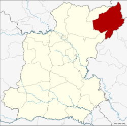
Amphoe Nong Phok
|
Nong Phok หนองพอก |
|
|---|---|
| Province: | Roi Et |
| Surface: | 599.5 km² |
| Residents: | 65,923 (2013) |
| Population density : | 107.8 U / km² |
| ZIP : | 45210 |
| Geocode : | 4509 |
| map | |

|
|
Amphoe Nong Phok ( Thai : อำเภอ หนองพอก ) is a district ( amphoe - administrative district) in the province of Roi Et . The province of Roi Et is located in the northeast region of Thailand , the so-called Isan .
geography
Amphoe Nong Phok borders the following districts (clockwise from the south): Amphoe Selaphum , Phon Thong and Moei Wadi in the province of Roi Et, Amphoe Nong Sung in the province of Mukdahan , and to Amphoe Loeng Nok Tha and Kut Chum der Yasothon Province .
history
The history of the district goes back to the village of Ban Nong Phok, which belonged to the Tambon Kok Pho, today Amphoe Phon Thong . On June 16, 1965, it was raised to a "branch circle" ( King Amphoe ) , consisting of the two tambon Kok Pho and Bueng Ngam. On June 28, 1973, it was promoted to Amphoe.
Attractions
- Phra Maha Chedi Chai Mongkol ( พระ มหา เจ ดี ชัยมงคล ) - one of the largest chedis in Thailand: it is 101 meters wide, 101 meters long and 101 meters high. It was built on 101 rai (16.16 hectares ) of land. The number 101 (in Thai: Roi-Et) symbolizes the name of the province. The chedi is said to contain relics of the Buddha. It belongs to Wat Pha Namthip Thep Prasit Vararam, a Buddhist temple ( Wat ) .
- There is also an arboretum (Thai: สวน รุกขชาติ ), the "Dong Meu Arboretum", and a so-called "Literary Botanical Garden" ( สวน พฤกษศาสตร์ วรรณคดี ) in the district. The “Northeastern Literary Botanical Garden” (Thai: สวน พฤกษศาสตร์ วรรณคดี ภาค ตะวันออก เฉียง เหนือ ) was opened in 1985 in honor of King Bhumibol Adulyadej's 60th birthday. At a size of 1000 Rai it contains plants that are mentioned in Thai literature and that have therefore acquired cultural and historical significance.
Administrative units
Provincial Administration
Nong Phok County is divided into nine tambon ("subdistricts" or "parishes"), which are further subdivided into 120 muban ("villages").
| No. | Surname | Thai | Muban | Pop. |
|---|---|---|---|---|
| 1. | Nong Phok | หนองพอก | 14th | 9,396 |
| 2. | Bueng Ngam | บึง งาม | 11 | 5,609 |
| 3. | Phukhao Thong | ภูเขาทอง | 17th | 9,636 |
| 4th | Kok Pho | กก โพธิ์ | 12 | 6,412 |
| 5. | Khok Sawang | โคก สว่าง | 10 | 4,826 |
| 6th | Nong Khun Yai | หนอง ขุ่น ใหญ่ | 13 | 8.094 |
| 7th | Rop Mueang | รอบ เมือง | 19th | 9,931 |
| 8th. | Pha Nam Yoi | ผา น้ำ ย้อย | 13 | 6.001 |
| 9. | Tha Sida | ท่า สี ดา | 11 | 6,018 |
Local administration
There are two municipalities with "small town" status ( Thesaban Tambon ) in the district:
- Tha Sida (Thai: เทศบาล ตำบล ท่า สี ดา ) consisting of the complete tambon Tha Sida.
- Nong Phok (Thai: เทศบาล ตำบล หนองพอก ) consisting of the parts of the Tambon Nong Phok, Rop Mueang.
There are also eight " Tambon Administrative Organizations " ( องค์การ บริหาร ส่วน ตำบล - Tambon Administrative Organizations, TAO):
- Nong Phok (Thai: องค์การ บริหาร ส่วน ตำบล หนองพอก ) consisting of parts of the Tambon Nong Phok.
- Bueng Ngam (Thai: องค์การ บริหาร ส่วน ตำบล บึง งาม ) consisting of the complete tambon Bueng Ngam.
- Phukhao Thong (Thai: องค์การ บริหารส่วน ตำบล ภูเขาทอง ) consisting of the complete tambon Phukhao Thong.
- Kok Pho (Thai: องค์การ บริหาร ส่วน ตำบล กก โพธิ์ ) consisting of the complete Tambon Kok Pho.
- Khok Sawang (Thai: องค์การ บริหาร ส่วน ตำบล โคก สว่าง ) consisting of the complete tambon Khok Sawang.
- Nong Khun Yai (Thai: องค์การ บริหาร ส่วน ตำบล หนอง ขุ่น ใหญ่ ) consisting of the complete tambon Nong Khun Yai.
- Rop Mueang (Thai: องค์การ บริหาร ส่วน ตำบล รอบ เมือง ) consisting of parts of the Tambon Rop Mueang.
- Pha Nam Yoi (Thai: องค์การ บริหาร ส่วน ตำบล ผา น้ำ ย้อย ) consisting of the complete tambon Pha Nam Yoi.
Individual evidence
- ↑ ประกาศ กระทรวง มหาดไทย เรื่อง แบ่ง ท้องที่ ตั้ง เป็น กิ่ง อำเภอ . In: Royal Gazette . 81, No. 47 ง , June 15, 1965, p. 1616-.
- ↑ พระราชกฤษฎีกา ตั้ง อำเภอ เขาพนม อำเภอ สนามชัยเขต อำเภอ แม่อาย อำเภอ ขามสะแกแสง อำเภอ เก้าเลี้ยว อำเภอ โพธิ์ประทับช้าง อำเภอ หนองพอก อำเภอ ละอุ่น อำเภอ ทุ่งหว้า และ อำเภอ ศรีธาตุ พ.ศ. ๒๕๑๖ . In: Royal Gazette . 90, No. 75 ก ฉบับ พิเศษ (special), June 28, 1973, pp. 32-36.
- ↑ List of Literary Botanical Gardens of dnp.go.th ( Memento of the original from June 16, 2011 in the Internet Archive ) Info: The archive link has been inserted automatically and has not yet been checked. Please check the original and archive link according to the instructions and then remove this notice. (in English)
- ↑ 2013 population statistics ( Thai ) Department of Provincial Administration. Retrieved August 3, 2014.
Web links
Coordinates: 16 ° 19 ′ N , 104 ° 12 ′ E

