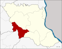
Nong Sung district
|
Amphoe Nong Sung อำเภอ หนอง สูง |
|
|---|---|
| Province: | Mukdahan |
| Surface: | 410.4 km² |
| Residents: | 20,844 (2013) |
| Population density : | 50.9 U / km² |
| ZIP : | 49160 |
| Geocode : | 4907 |
| map | |

|
|
Amphoe Nong Sung ( Thai อำเภอ หนอง สูง ) is a district ( Amphoe - administrative district) in the west of the Mukdahan Province . The Mukdahan Province is located in the western part of the northeast region of Thailand , the so-called Isan .
geography
Neighboring districts are (from north clockwise): Khamcha-i , Mueang Mukdahan and Nikhom Kham Soi Province Mukdahan, Loeng Nok Tha in the province of Yasothon , Nong Phok in the province of Roi Et and Kuchinarai the province of Kalasin .
history
Nong Sung was first established on March 1, 1985 as a "branch circle" ( King Amphoe ) by separating five tambon from Amphoe Khamcha-i . On November 3, 1993, Nong Sung was promoted to Amphoe.
administration
Provincial Administration
Nong Sung County is divided into 6 tambon ("subdistricts" or "parishes"), which are further subdivided into 44 muban ("villages").
| No. | Surname | Thai | Muban | Pop. |
|---|---|---|---|---|
| 1. | Nong Sung | หนอง สูง | 5 | 1,794 |
| 2. | Non Yang | โนน ยาง | 10 | 5,991 |
| 3. | Phu Wong | ภู วง | 7th | 2,706 |
| 4th | Ban Pao | บ้าน เป้า | 6th | 3,574 |
| 5. | Nong Sung Tai | หนอง สูง ใต้ | 8th | 3,947 |
| 6th | Nong Sung Nuea | หนอง สูง เหนือ | 8th | 2,832 |
Local administration
There are three municipalities with "small town" status ( Thesaban Tambon ) in the district:
- Phu Wong (Thai: เทศบาล ตำบล ภู วง ) consists of the entire tambon Phu Wong,
- Ban Pao (Thai: เทศบาล ตำบล บ้าน เป้า ) consists of the entire tambon Ban Pao,
- Nong Sung Nuea (Thai: เทศบาล ตำบล หนอง สูง เหนือ ) consists of the entire Tambon Nong Sung and Nong Sung Nuea.
There are also two " Tambon Administrative Organizations " ( องค์การ บริหาร ส่วน ตำบล - Tambon Administrative Organizations, TAO):
- Non Yang (Thai: องค์การ บริหาร ส่วน ตำบล โนน ยาง )
- Nong Sung Tai (Thai: องค์การ บริหาร ส่วน ตำบล หนอง สูง ใต้ )
Individual evidence
- ↑ ประกาศ กระทรวง มหาดไทย เรื่อง แบ่ง เขต ท้องที่ อำเภอ คำชะอี จังหวัด มุกดาหาร ตั้ง เป็น กิ่ง อำเภอ หนอง สูง . In: Royal Gazette . 102, No. 36 ง , March 26, 1985, p. 1437.
- ↑ พระราชกฤษฎีกา ตั้ง อำเภอ ลำ ทับ อำเภอ ร่องคำ อำเภอ เวียง แหง อำเภอ นา โยง อำเภอ แก้ง สนาม นาง อำเภอ โนน แดง อำเภอ บ้านหลวง อำเภอ กะพ้อ อำเภอ ศรี บรรพต บรรพต อำเภอ แก่ง กระจาน อำเภอ อำเภอ หนอง สูง อำเภอ สบ เมย อำเภอ เมย วดี อำเภอ โคก เจริญ อำเภอ ทุ่งหัวช้าง อำเภอ วัง ขาว ขาว ขาว ขาว ขาว ขาว หิน อำเภอ ดอนพุด อำเภอ บึง โขง หลง และ อำเภอ ห้วย ค ต พ.ศ. ๒๕๓๖ . In: Royal Gazette . 110, No. 179 ก ฉบับ พิเศษ (special), November 3, 1993, pp. 1-3.
- ↑ 2013 population statistics ( Thai ) Department of Provincial Administration. Retrieved July 31, 2014.
Web links
Coordinates: 16 ° 29 ′ N , 104 ° 21 ′ E