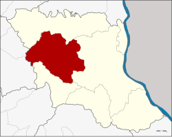
Amphoe Khamcha-i
|
Amphoe Khamcha-i อำเภอ คำชะอี |
|
|---|---|
| Province: | Mukdahan |
| Surface: | 645.7 km² |
| Residents: | 47,434 (2013) |
| Population density : | 72.8 U / km² |
| ZIP : | 49110 |
| Geocode : | 4905 |
| map | |

|
|
Amphoe Khamcha-i ( Thai อำเภอ คำชะอี ) is a district ( Amphoe - administrative district) in the west of the province of Mukdahan . The Mukdahan Province is located in the western part of the northeast region of Thailand , the so-called Isan .
geography
Neighboring counties and areas are (clockwise from north): the Amphoe Dong Luang , Mueang Mukdahan and Nong Sung of Mukdahan Province, and the Amphoe Kuchinarai and Khao Wong in Kalasin Province .
history
Khamcha-i was initially set up as a "branch circle" ( King Amphoe ) on June 24, 1941 , by separating the six tambon Khamcha-i, Nong Sung, Ban Song, Ban Kho, Ban Lao and Nong Ian from the Mueang Mukdahan district. In 1956, Khamcha-i received full amphoe status. When the new Mukdahan Province was created in 1982, Khamcha-i was one of the counties that originally made up the new province.
administration
Provincial Administration
The district of Khamcha-i is divided into nine tambon ("subdistricts" or "municipalities"), which are further subdivided into 88 muban ("villages").
| No. | Surname | Thai | Muban | Pop. |
|---|---|---|---|---|
| 3. | Ban song | บ้าน ซ่ ง | 7th | 4,188 |
| 4th | Khamcha-i | คำชะอี | 14th | 6,991 |
| 5. | Nong Ian | หนอง เอี่ยน | 10 | 5,371 |
| 6th | Ban Kho | บ้าน ค้อ | 11 | 7,246 |
| 7th | Ban Lao | บ้าน เหล่า | 11 | 5,542 |
| 8th. | Phon Ngam | โพน งาม | 10 | 5,299 |
| 11. | Lao Sang Tho | เหล่า สร้าง ถ่อ | 7th | 4,028 |
| 12. | Kham Bok | คำ บก | 6th | 2,507 |
| 14th | Nam Thiang | น้ำ เที่ยง | 12 | 6.262 |
Note: The missing numbers (geocodes) belong to the tambon that today Amphoe Nong Sung consists of.
Local administration
There is one municipality with "small town" status ( Thesaban Tambon ) in the district:
- Khamcha-i (Thai: เทศบาล ตำบล คำชะอี ) consists of parts of the Tambon Nam Thiang.
There are also nine " Tambon Administrative Organizations " ( องค์การ บริหาร ส่วน ตำบล - Tambon Administrative Organizations, TAO):
- Ban Song (Thai: องค์การ บริหาร ส่วน ตำบล บ้าน ซ่ ง )
- Khamcha-i (Thai: องค์การ บริหาร ส่วน ตำบล คำชะอี )
- Nong Ian (Thai: องค์การ บริหาร ส่วน ตำบล หนอง เอี่ยน )
- Ban Kho (Thai: องค์การ บริหาร ส่วน ตำบล บ้าน ค้อ )
- Ban Lao (Thai: องค์การ บริหาร ส่วน ตำบล บ้าน เหล่า )
- Phon Ngam (Thai: องค์การ บริหาร ส่วน ตำบล โพน งาม )
- Lao Sang Tho (Thai: องค์การ บริหาร ส่วน ตำบล เหล่า สร้าง ถ่อ )
- Kham Bok (Thai: องค์การ บริหาร ส่วน ตำบล คำ บก )
- Nam Thiang (Thai: องค์การ บริหาร ส่วน ตำบล น้ำ เที่ยง )
Individual evidence
- ↑ ประกาศ กระทรวง มหาดไทย เรื่อง ตั้ง กิ่ง อำเภอ คำชะอี ขึ้น อำเภอ มุกดาหาร จังหวัด นครพนม . In: Royal Gazette . 58, No. 0 ง , May 20, 1941, pp. 1264-1265.
- ↑ พระราชกฤษฎีกา จัดตั้ง อำเภอ นาทวี อำเภอ สะบ้าย้อย อำเภอ คำชะอี อำเภอ ย่านตาขาว อำเภอ วัดโบสถ์ อำเภอ หนองบัว อำเภอ วัฒนานคร อำเภอ แสวงหา อำเภอ ท่าชนะ อำเภอ พระพุทธบาท อำเภอ โนนสัง อำเภอ อำเภอ บำเหน็จณรงค์ อำเภอ คอนสวรรค์ อำเภอ บ้านโฮ่ง บ้านโฮ่ง อำเภอ คีรีมาศ อำเภอ ชนแดน อำเภอ แม่แจ่ม อำเภอ ไทรน้อย และ อำเภอ บ้านแพง พ.ศ. ๒๔๙๙ . In: Royal Gazette . 73, No. 46 ก , June 5, 1956, pp. 657-661.
- ↑ 2013 population statistics ( Thai ) Department of Provincial Administration. Retrieved July 31, 2014.
Web links
Coordinates: 16 ° 35 ' N , 104 ° 25' E
