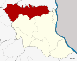
Dong Luang district
|
Amphoe Dong Luang อำเภอ ดงหลวง |
|
|---|---|
| Province: | Mukdahan |
| Surface: | 1076.2 km² |
| Residents: | 37,934 (2013) |
| Population density : | 33.3 U / km² |
| ZIP : | 49140 |
| Geocode : | 4904 |
| map | |

|
|
Amphoe Dong Luang ( Thai อำเภอ ดงหลวง ) is a district ( Amphoe - Administrative District) in the north of the Mukdahan Province . The Mukdahan Province is located in the western part of the northeast region of Thailand , the so-called Isan .
geography
Neighboring counties and areas are (clockwise from the south): Amphoe Mueang Mukdahan and Khamcha-i in Mukdahan Province, Amphoe Khao Wong and Na Khu in Kalasin Province , Amphoe Tao Ngoi in Sakon Nakhon Province , and Amphoe Na Kae and That Phanom in Nakhon Phanom Province .
history
Dong Luang was initially set up as a “branch circle” ( King Amphoe ) on April 1, 1877 , by separating the three tambon Dong Luang, Kok Tum and Nong Bua from Amphoe Na Kae (now Nakhon Phanom Province). When the new Mukdahan Province was established in 1982, Dong Luang was one of the areas from which the new province was created. It was initially subordinated to Mueang Mukdahan County. On July 16, 1984, Dong Luang was promoted to Amphoe.
administration
Provincial Administration
Dong Luang County is divided into six tambon ("subdistricts" or "parishes"), which are further subdivided into 60 muban ("villages").
| No. | Surname | Thai | Muban | Pop. |
|---|---|---|---|---|
| 1. | Dong Luang | ดงหลวง | 12 | 8,244 |
| 2. | Nong Bua | หนองบัว | 8th | 4,531 |
| 3. | Kok Tum | กก ตูม | 16 | 9,072 |
| 4th | Nong Khaen | หนองแค น | 7th | 5,018 |
| 5. | Chanot Noi | ชะ โน ด น้อย | 9 | 5,537 |
| 6th | Phang Daeng | พัง แดง | 8th | 5,532 |
Local administration
There are three municipalities with "small town" status ( Thesaban Tambon ) in the district:
- Dong Luang (Thai: เทศบาล ตำบล ดงหลวง ) consisting of the entire tambon Dong Luang.
- Kok Tum (Thai: เทศบาล ตำบล กก ตูม ) consisting of the entire Tambon Kok Tum.
- Nong Khaen (Thai: เทศบาล ตำบล หนองแค น ) consisting of the entire Tambon Nong Khaen.
There are also three " Tambon Administrative Organizations " ( องค์การ บริหาร ส่วน ตำบล - Tambon Administrative Organizations, TAO):
- Nong Bua (Thai: องค์การ บริหาร ส่วน ตำบล หนองบัว )
- Chanot Noi (Thai: องค์การ บริหาร ส่วน ตำบล ชะ โน ด น้อย )
- Phang Daeng (Thai: องค์การ บริหาร ส่วน ตำบล พัง แดง )
Individual evidence
- ↑ ประกาศ กระทรวง มหาดไทย เรื่อง แบ่ง ท้องที่ อำเภอ นาแก จังหวัด นครพนม ตั้ง เป็น กิ่ง อำเภอ ดงหลวง . In: Royal Gazette . 94, No. 26 ง , March 29, 1977, p. 1316.
- ↑ พระราชกฤษฎีกา ตั้ง อำเภอ ลาน กระบือ อำเภอ ดงหลวง อำเภอ ทรายมูล อำเภอ แม่เมาะ และ อำเภอ บัว เชด พ.ศ. ๒๕๒๗ . In: Royal Gazette . 101, No. 96 ก ฉบับ พิเศษ (special), July 16, 1984, pp. 10-12.
- ↑ 2013 population statistics ( Thai ) Department of Provincial Administration. Retrieved July 31, 2014.
Web links
Coordinates: 16 ° 49 ' N , 104 ° 32' E