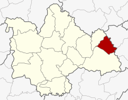
Amphoe Khao Wong
|
Khao Wong เขาวง |
|
|---|---|
| Province: | Kalasin |
| Surface: | 205.1 km² |
| Residents: | 34,847 (2013) |
| Population density : | 171.3 U / km² |
| ZIP : | 46160 |
| Geocode : | 4606 |
| map | |

|
|
Amphoe Khao Wong ( Thai : อำเภอ เขาวง ) is a district ( amphoe - administrative district) of Kalasin Province . The province of Kalasin is located in the northeast region of Thailand , the so-called Isan .
geography
The neighboring districts are starting clockwise from the south: the Amphoe Kuchinarai and Na Khu in the province of Kalasin, and Amphoe Dong Luang and Khamcha-i the province of Mukdahan .
history
Khao Wong was initially set up as a “branch circle” ( King Amphoe ) on June 1, 1969 by separating the five Tambon Khum Kao, Song Plueai, Na Khu, Phu Laen Chang and Nong Phue from the Amphoe Kuchinarai . On April 1, 1974, Khao Wong was promoted to Amphoe.
administration
Provincial Administration
Khao Wong County is divided into six tambon ("subdistricts" or "parishes"), which are further subdivided into 71 muban ("villages").
| No. | Surname | Thai | Muban | Pop. |
|---|---|---|---|---|
| 1. | Khum Kao | คุ้ม เก่า | 18th | 9,244 |
| 2. | Song Plueai | สง เปลือย | 16 | 7.108 |
| 3. | Nong Phue | หนอง ผื อ | 10 | 5,847 |
| 6th | Kut Sim Khum Mai | กุด สิ ม คุ้ม ใหม่ | 13 | 6,810 |
| 8th. | Saphang Thong | สระ พัง ทอง | 7th | 2,892 |
| 11. | Kut Pla Khao | กุด ปลา ค้า ว | 7th | 2,946 |
Note: The missing numbers (geocodes) belong to the tambon that belong to the Amphoe Na Khu today .
Local administration
There are four municipalities with "small town" status ( Thesaban Tambon ) in the district:
- Song Plueai (Thai: เทศบาล ตำบล สง เปลือย ) consists of the entire tambon Song Plueai.
- Kut Sim Khum Mai (Thai: เทศบาล ตำบล กุด สิ ม คุ้ม ใหม่ ) consists of parts of the tambon Kut Sim Khum Mai.
- Kut Sim (Thai: เทศบาล ตำบล กุด สิ ม ) consists of parts of the Tambon Khum Kao and Kut Sim Khum Mai as well as the entire Tambon Kut Pla Khao.
- Saphang Thong (Thai: เทศบาล ตำบล สระ พัง ทอง ) consists of the entire Tambon Saphang Thong.
There are also two " Tambon Administrative Organizations " ( องค์การ บริหาร ส่วน ตำบล - Tambon Administrative Organizations, TAO):
- Khum Kao (Thai: องค์การ บริหาร ส่วน ตำบล คุ้ม เก่า )
- Nong Phue (Thai: องค์การ บริหาร ส่วน ตำบล หนอง ผื อ )
Individual evidence
- ↑ ประกาศ กระทรวง มหาดไทย เรื่อง แบ่ง ท้องที่ ตั้ง เป็น กิ่ง อำเภอ . In: Royal Gazette . 86, No. 55 ง , June 17, 1969, p. 1974.
- ↑ พระราชกฤษฎีกา ตั้ง อำเภอ เขาวง อำเภอ เชียงม่วน อำเภอ ดอนตาล อำเภอ ชาติตระการ อำเภอ ภูเรือ อำเภอ เคียน ซา อำเภอ น้ำโสม อำเภอ หนองวัวซอ และ อำเภอ น้ำยืน พ.ศ. ๒๕๑๗ . In: Royal Gazette . 91, No. 54 ก special ( ฉบับ พิเศษ ), March 28, 1974, pp. 30-33.
- ↑ 2013 population statistics ( Thai ) Department of Provincial Administration. Retrieved July 28, 2014.
Web links
Coordinates: 16 ° 42 ' N , 104 ° 5' E
