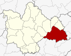
Amphoe Kuchinarai
|
Kuchinarai กุ ฉิ นารายณ์ |
|
|---|---|
| Province: | Kalasin |
| Surface: | 739.247 km² |
| Residents: | 101,398 (2013) |
| Population density : | 136.3 U / km² |
| ZIP : | 46110 |
| Geocode : | 4605 |
| map | |

|
|
Amphoe Kuchinarai ( Thai : อำเภอ กุ ฉิ นารายณ์ ) is a district ( Amphoe - administrative district) of the Kalasin Province . The province of Kalasin is located in the northeast region of Thailand , the so-called Isan .
geography
The neighboring districts start clockwise from the west: the Amphoe Don Chan , Na Mon , Huai Phueng , Na Khu and Khao Wong in the province of Kalasin, the Amphoe Khamcha-i and Nong Sung in the province of Mukdahan , and the Amphoe Moei Wadi , Phon Thong and Pho Chai of Roi Et Province .
administration
Provincial Administration
The district of Kuchinarai is divided into twelve tambon ("subdistricts" or "communities"), which are further subdivided into 145 muban ("villages").
| No. | Surname | Thai | Muban | Pop. |
|---|---|---|---|---|
| 1. | Bua Khao | บัวขาว | 16 | 20,292 |
| 2. | Chaen Laen | แจ น แลน | 9 | 6,414 |
| 3. | Lao Yai | เหล่า ใหญ่ | 12 | 7.178 |
| 4th | Chum Chang | จุ ม จัง | 15th | 9,477 |
| 5. | Lao Hai Ngam | เหล่า ไฮ งาม | 12 | 7.117 |
| 6th | Kut Wa | กุด หว้า | 13 | 9,970 |
| 7th | Sam Kha | สามขา | 18th | 9,818 |
| 8th. | Well Kham | นา ขาม | 17th | 12,782 |
| 9. | Nong Hang | หนอง ห้าง | 9 | 5,059 |
| 10. | Okay | นา โก | 9 | 4,820 |
| 11. | Som Sa-at | สม สะอาด | 7th | 4,333 |
| 12. | Kut Khao | กุด ค้า ว | 8th | 4.138 |
Local administration
There is one commune with "city" status ( Thesaban Mueang ) in the district:
- Bua Khao (Thai: เทศบาล เมือง บัวขาว ) consists of parts of the Tambon Bua Khao.
There are four municipalities with "small town" status ( Thesaban Tambon ) in the district:
- Lao Yai (Thai: เทศบาล ตำบล เหล่า ใหญ่ ) consists of the whole tambon Lao Yai.
- Kut Wa (Thai: เทศบาล ตำบล กุด หว้า ) consists of parts of the tambon Kut Wa.
- Na Kham (Thai: เทศบาล ตำบล นา ขาม ) consists of the whole tambon Na Kham.
- Chum Chang (Thai: เทศบาล ตำบล จุ ม จัง ) consists of the whole Tambon Chum Chang.
There are also nine " Tambon Administrative Organizations " ( องค์การ บริหาร ส่วน ตำบล - Tambon Administrative Organizations, TAO):
- Bua Khao (Thai: องค์การ บริหาร ส่วน ตำบล บัวขาว )
- Chaen Laen (Thai: องค์การ บริหาร ส่วน ตำบล แจ น แลน )
- Lao Hai Ngam (Thai: องค์การ บริหาร ส่วน ตำบล เหล่า ไฮ งาม )
- Kut Wa (Thai: องค์การ บริหาร ส่วน ตำบล กุด หว้า )
- Sam Kha (Thai: องค์การ บริหาร ส่วน ตำบล สามขา )
- Nong Hang (Thai: องค์การ บริหาร ส่วน ตำบล หนอง ห้าง )
- Na Ko (Thai: องค์การ บริหาร ส่วน ตำบล นา โก )
- Som Sa-at (Thai: องค์การ บริหาร ส่วน ตำบล สม สะอาด )
- Kut Khao (Thai: องค์การ บริหาร ส่วน ตำบล กุด ค้า ว )
Individual evidence
- ↑ 2013 population statistics ( Thai ) Department of Provincial Administration. Retrieved July 28, 2014.
Web links
Coordinates: 16 ° 32 ' N , 104 ° 3' E
