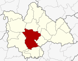
Amphoe Mueang Kalasin
|
Amphoe Mueang Kalasin อำเภอ เมือง กาฬสินธุ์ |
|
|---|---|
| Province: | Kalasin |
| Surface: | 649.9 km² |
| Residents: | 146,394 (2013) |
| Population density : | 224.0 U / km² |
| ZIP : | 46000 |
| Geocode : | 4601 |
| map | |

|
|
Amphoe Mueang Kalasin (in Thai : อำเภอ เมือง กาฬสินธุ์ ) is a district ( amphoe - administrative district) in the province of Kalasin . The province of Kalasin is located in the northeast region of Thailand , the so-called Isan .
geography
The district is located about 520 kilometers northeast of Bangkok .
Neighboring districts (clockwise from north): the Amphoe Sahatsakhan , Somdet , Na Mon , Don Chan , Kamalasai , Khong Chai , Yang Talat and Nong Kung Si of Kalasin Province.
history
In 1913 the district of Uthai Kalasin was renamed Mueang Kalasin.
administration
Provincial Administration
Mueang Kalasin County is divided into 17 tambon ("subdistricts" or "parishes"), which are further subdivided into 185 muban ("villages").
| No. | Surname | Thai | Muban | Pop. |
|---|---|---|---|---|
| 1. | Kalasin | กาฬสินธุ์ | - | 34,752 |
| 2. | Nuea | เหนือ | 12 | 8,027 |
| 3. | Lup | หลุบ | 16 | 11,390 |
| 4th | Phai | ไผ่ | 9 | 5,313 |
| 5. | Lam Pao | ลำ ปาว | 11 | 6.097 |
| 6th | Lam Phan | ลำ พาน | 16 | 9.214 |
| 7th | Chiang Khruea | เชียง เครือ | 11 | 7.156 |
| 8th. | Bueng Wichai | บึง วิชัย | 9 | 6.234 |
| 9. | Huai Pho | ห้วย โพธิ์ | 18th | 11,760 |
| 11. | Phu Po | ภู ปอ | 9 | 6,615 |
| 13. | Phu Din | ภู ดิน | 14th | 5,740 |
| 15th | Nong Kung | หนอง กุ ง | 8th | 4,736 |
| 16. | Sounded Muen | กลาง หมื่น | 12 | 4,781 |
| 17th | Khamin | ขมิ้น | 11 | 6,540 |
| 19th | Phon Thong | โพนทอง | 10 | 6,456 |
| 20th | Well Chan | นา จาร ย์ | 9 | 6.218 |
| 21st | Lam Khlong | ลำคลอง | 10 | 5,365 |
The missing numbers (geocodes) refer to the tambon that make up the Don Chan district today.
Local administration
There is one commune with "city" status ( Thesaban Mueang ) in the district:
- Kalasin (Thai: เทศบาล เมือง กาฬสินธุ์ )
There are also 15 municipalities with "small town" status ( Thesaban Tambon ) in the district:
- Nuea (Thai: เทศบาล ตำบล เหนือ )
- Lup (Thai: เทศบาล ตำบล หลุบ )
- Phai (Thai: เทศบาล ตำบล ไผ่ )
- Lam Phan (Thai: เทศบาล ตำบล ลำ พาน )
- Chiang Khruea (Thai: เทศบาล ตำบล เชียง เครือ )
- Bueng Wichai (Thai: เทศบาล ตำบล บึง วิชัย )
- Phu Po (Thai: เทศบาล ตำบล ภู ปอ )
- Phu Din (Thai: เทศบาล ตำบล ภู ดิน )
- Klang Muen (Thai: เทศบาล ตำบล กลาง หมื่น )
- Khamin (Thai: เทศบาล ตำบล ขมิ้น )
- Phon Thong (Thai: เทศบาล ตำบล โพนทอง )
- Na Chan (Thai: เทศบาล ตำบล นา จาร ย์ )
- Nong So (Thai: เทศบาล ตำบล หนอง สอ )
- Huai Pho (Thai: เทศบาล ตำบล ห้วย โพธิ์ )
- Lam Khlong (Thai: เทศบาล ตำบล ลำคลอง )
There is also a " Tambon Administrative Organization " ( องค์การ บริหาร ส่วน ตำบล - Tambon Administrative Organization, TAO):
- Nong Kung (Thai: องค์การ บริหาร ส่วน ตำบล หนอง กุ ง )
Individual evidence
- ↑ แจ้ง ความ กระทรวง มหาดไทย เรื่อง เปลี่ยน นาม อำเภอ . In: Royal Gazette . 30, No. 0 ง , October 19, 1913, pp. 1619–1620.
- ↑ 2013 population statistics ( Thai ) Department of Provincial Administration. Retrieved July 28, 2014.
Web links
Coordinates: 16 ° 26 ' N , 103 ° 31' E
