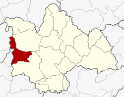
Huai Mek district
|
Huai Mek ห้วยเม็ก |
|
|---|---|
| Province: | Kalasin |
| Surface: | 291.01 km² |
| Residents: | 51,030 (2013) |
| Population density : | 170.8 U / km² |
| ZIP : | 46170 |
| Geocode : | 4608 |
| map | |

|
|
Amphoe Huai Mek ( Thai : อำเภอ ห้วยเม็ก ) is a district ( Amphoe - administrative district) in the west of Kalasin Province . The province of Kalasin is located in the northeast region of Thailand , the so-called Isan .
geography
The neighboring districts start clockwise from the northwest: the Amphoe Nong Kung Si and Yang Talat in the province of Kalasin, Amphoe Chuen Chom in the province of Maha Sarakham and Amphoe Kranuan in the province of Khon Kaen .
history
Huai Mek was initially set up as a “branch circle” ( King Amphoe ) on November 1, 1970 , by separating the three tambon Huai Mek, Kut Don and Bueng Na Riang from the Amphoe Yang Talat . On April 12, 1977, Huai Mek was promoted to Amphoe.
administration
Provincial Administration
Huai Mek County is divided into nine tambon ("subdistricts" or "parishes"), which are further subdivided into 84 muban ("villages").
| No. | Surname | Thai | Muban | Pop. |
|---|---|---|---|---|
| 1. | Huai Mek | ห้วยเม็ก | 15th | 9,599 |
| 2. | Kham Yai | คำ ใหญ่ | 12 | 7.502 |
| 3. | Kut Don | กุด โดน | 12 | 8,531 |
| 4th | Bueng Na Riang | บึง นา เรียง | 7th | 3,975 |
| 5. | Hua Hin | หัวหิน | 8th | 4,498 |
| 6th | Phimun | พิ มูล | 8th | 4,252 |
| 7th | Kham Mueat Kaeo | คำ เหมือด แก้ว | 9 | 5,882 |
| 8th. | Non Sa-at | โนนสะอาด | 7th | 4,225 |
| 9. | Sai Thong | ทราย ทอง | 6th | 2,566 |
Local administration
There are four municipalities with "small town" status ( Thesaban Tambon ) in the district:
- Tha Lat Dong Yang (Thai: เทศบาล ตำบล ท่า ลาด ดง ยาง ) consists of parts of the Tambon Huai Mek.
- Kham Mueat Kaeo (Thai: เทศบาล ตำบล คำ เหมือด แก้ว ) consists of the whole Tambon Kham Mueat Kaeo.
- Kham Yai (Thai: เทศบาล ตำบล คำ ใหญ่ ) consists of parts of the Tambon Kham Yai.
- Huai Mek (Thai: เทศบาล ตำบล ห้วยเม็ก ) consists of further parts of the Tambon Huai Mek.
There are also seven " Tambon Administrative Organizations " ( องค์การ บริหาร ส่วน ตำบล - Tambon Administrative Organizations, TAO):
- Kham Yai (Thai: องค์การ บริหาร ส่วน ตำบล คำ ใหญ่ )
- Kut Don (Thai: องค์การ บริหาร ส่วน ตำบล กุด โดน )
- Bueng Na Riang (Thai: องค์การ บริหาร ส่วน ตำบล บึง นา เรียง )
- Hua Hin (Thai: องค์การ บริหาร ส่วน ตำบล หัวหิน )
- Phimun (Thai: องค์การ บริหารส่วน ตำบล พิ มูล )
- Non Sa-at (Thai: องค์การ บริหาร ส่วน ตำบล โนนสะอาด )
- Sai Thong (Thai: องค์การ บริหาร ส่วน ตำบล ทราย ทอง )
Individual evidence
- ↑ ประกาศ กระทรวง มหาดไทย เรื่อง แบ่ง ท้องที่ ตั้ง เป็น กิ่ง อำเภอ กิ่ง อำเภอ ห้วยเม็ก . In: Royal Gazette . 87, No. 101 ง special ( ฉบับ พิเศษ ), November 1, 1970, p. 6.
- ↑ พระราชกฤษฎีกา ตั้ง อำเภอ ปลายพระยา อำเภอ ห้วยเม็ก อำเภอ ละแม อำเภอ แม่จริม อำเภอ หนองกี่ อำเภอ โคกปีบ อำเภอ เกาะพะงัน อำเภอ สนม อำเภอ โซ่พิสัย อำเภอ โนนสะอาด และ อำเภอ นาจะหลวย พ.ศ. ๒๕๒๐ . In: Royal Gazette . 94, No. 31 ก , April 12, 1977, pp. 326-330.
- ↑ 2013 population statistics ( Thai ) Department of Provincial Administration. Retrieved July 28, 2014.
Web links
Coordinates: 16 ° 35 ' N , 103 ° 14' E
