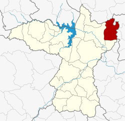
Amphoe Kranuan
|
Kranuan กระนวน |
|
|---|---|
| Province: | Khon Kaen |
| Surface: | 322.017 km² |
| Residents: | 78,765 (2013) |
| Population density : | 240.8 U / km² |
| ZIP : | 40170 |
| Geocode : | 4009 |
| map | |

|
|
Amphoe Kranuan ( Thai : อำเภอ กระนวน ) is a district ( amphoe - administrative district) in the province of Khon Kaen . The province of Khon Kaen is located in the northeast region of Thailand , the so-called Isan .
geography
Neighboring counties (clockwise from south): Sam Sung and Nam Phong in Khon Kaen Province, Non Sa-at and Kumphawapi in Udon Thani Province , Tha Khantho , Nong Kung Si and Huai Mek in the province Kalasin and Chuen Chom district in Maha Sarakham Province .
history
Kranuan was initially set up as a "branch circle" ( King Amphoe ) on January 1, 1948 by being separated from the Nam Phong district . On July 22, 1958, Kranuan was promoted to Amphoe.
Administrative units
Provincial Administration
The district of Kranuan is divided into nine tambon ("subdistricts" or "communities"), which are further subdivided into 98 muban ("villages").
| No. | Surname | Thai | Muban | Pop. |
|---|---|---|---|---|
| 1. | Nong Ko | หนอง โก | 19th | 21,596 |
| 2. | Nong Kung Yai | หนอง กุ ง ใหญ่ | 13 | 10,555 |
| 5. | Huai Chot | ห้วย โจ ด | 2 | 6,340 |
| 6th | Huai Yang | ห้วย ยาง | 8th | 5,982 |
| 7th | Ban Fang | บ้านฝาง | 11 | 7,986 |
| 9. | Dun Sat | ดู น สาด | 2 | 8,078 |
| 10. | Nong No. | หนอง โน | 7th | 6,355 |
| 11. | Nam Om | น้ำ อ้อม | - | 4,849 |
| 12. | Hua Na Kham | หัว นา คำ | - | 7,024 |
Note: Some of the Muban's data are not yet available.
Local administration
There is one commune with "city" status ( Thesaban Mueang ) in the district:
- Kranuan (Thai: เทศบาล เมือง กระนวน ) consists of parts of the Tambon Nong Ko.
There are three municipalities with "small town" status ( Thesaban Tambon ) in the district:
- Huai Yang (Thai: เทศบาล ตำบล ห้วย ยาง ) consists of the entire tambon Huai Yang.
- Nong No (Thai: เทศบาล ตำบล หนอง โน ) consists of the entire Tambon Nong No.
- Nam Om (Thai: เทศบาล ตำบล น้ำ อ้อม ) consists of the entire tambon Nam Om.
There are also six " Tambon Administrative Organizations " ( องค์การ บริหาร ส่วน ตำบล - Tambon Administrative Organizations, TAO):
- Nong Ko (Thai: องค์การ บริหาร ส่วน ตำบล หนอง โก )
- Nong Kung Yai (Thai: องค์การ บริหาร ส่วน ตำบล หนอง กุ ง ใหญ่ )
- Huai Chot (Thai: องค์การ บริหาร ส่วน ตำบล ห้วย โจ ด )
- Ban Fang (Thai: องค์การ บริหาร ส่วน ตำบล บ้านฝาง )
- Dun Sat (Thai: องค์การ บริหาร ส่วน ตำบล ดู น สาด )
- Hua Na Kham (Thai: องค์การ บริหาร ส่วน ตำบล หัว นา คำ )
Individual evidence
- ↑ 2013 population statistics ( Thai ) Department of Provincial Administration. Retrieved July 29, 2014.
Web links
Coordinates: 16 ° 42 ' N , 103 ° 5' E
