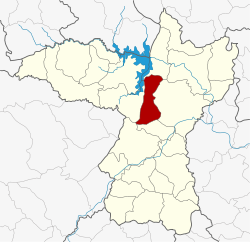
Ban Fang district
|
Ban Fang บ้านฝาง |
|
|---|---|
| Province: | Khon Kaen |
| Surface: | 334 km² |
| Residents: | 54,464 (2013) |
| Population density : | 148.1 U / km² |
| ZIP : | 40270 |
| Geocode : | 4002 |
| map | |

|
|
Amphoe Ban Fang ( Thai อำเภอ บ้านฝาง ) is a district ( Amphoe - Administrative District ) in the north of Khon Kaen Province . The province of Khon Kaen is located in the western part of the northeast region of Thailand , the so-called Isan .
history
Ban Fang was established on May 1, 1975 as a "branch circle" ( King Amphoe ) by separating the four Tambon Nong Bua, Pa Wai Nang, Ban Lao and Non Khong from Amphoe Mueang Khon Kaen. Ban Fang was finally upgraded to a full Amphoe on March 25, 1979.
geography
Amphoe Ban Fang is located in the north-central area of the province of Khon Kaen and, viewed from the north in a clockwise direction, borders on Amphoe Ubolratana , Mueang Khon Kaen , Phra Yuen , Mancha Khiri and Nong Ruea . All Amphoe are in Khon Kaen Province.
administration
Provincial Administration
Ban Fang County is divided into seven tambon ("subdistricts" or "parishes"), which are further subdivided into 65 muban ("villages").
| No. | Surname | Thai | Muban | Pop. |
|---|---|---|---|---|
| 1. | Nong Bua | หนองบัว | 11 | 7,257 |
| 2. | Pa Wai Nang | ป่า หวาย นั่ง | - | 7,861 |
| 3. | Non Khong | โนน ฆ้อง | 10 | 6,208 |
| 4th | Ban Lao | บ้าน เหล่า | 14th | 10,296 |
| 5. | Pa Manao | ป่า มะนาว | 9 | 6,308 |
| 6th | Ban Fang | บ้านฝาง | 11 | 10,766 |
| 7th | Khok Ngam | โคก งาม | 10 | 5,768 |
Local administration
There are six municipalities with "small town" status ( Thesaban Tambon ) in the district:
- Nong Bua (Thai: เทศบาล ตำบล หนองบัว ) consisting of the entire Tambon Nong Bua.
- Non Khong (Thai: เทศบาล ตำบล โนน ฆ้อง ) consisting of the entire Tambon Non Khong.
- Pa Manao (Thai: เทศบาล ตำบล ป่า มะนาว ) consisting of the entire tambon Pa Manao.
- Kaen Fang (Thai: เทศบาล ตำบล แก่น ฝาง ) consisting of parts of the Tambon Ban Fang.
- Khok Ngam (Thai: เทศบาล ตำบล โคก งาม ) consisting of the entire tambon Khok Ngam.
- Ban Fang (Thai: เทศบาล ตำบล บ้านฝาง ) consisting of the remaining parts of the Tambon Ban Fang.
There are also two " Tambon Administrative Organizations " ( องค์การ บริหาร ส่วน ตำบล - Tambon Administrative Organizations, TAO):
- Pa Wai Nang (Thai: องค์การ บริหาร ส่วน ตำบล ป่า หวาย นั่ง )
- Ban Lao (Thai: องค์การ บริหาร ส่วน ตำบล บ้าน เหล่า )
Individual evidence
- ↑ ประกาศ กระทรวง มหาดไทย เรื่อง แบ่ง ท้องที่ อำเภอ เมือง ขอนแก่น จังหวัด ขอนแก่น ตั้ง เป็น กิ่ง อำเภอ บ้านฝาง . In: Royal Gazette . 92, No. 89 ง , May 6, 1975, p. 1141. Retrieved March 21, 2014.
- ↑ พระราชกฤษฎีกา ตั้ง อำเภอ หนองกุงศรี อำเภอ ไทรงาม อำเภอ บ้านฝาง อำเภอ อุบลรัตน์ อำเภอ เวียงชัย อำเภอ ดอยเต่า อำเภอ นิคมคำสร้อย อำเภอ นาหว้า อำเภอ เสิงสาง อำเภอ ศรีสาคร อำเภอ บึงสามพัน อำเภอ นาดูน อำเภอ อำเภอ ค้อวัง อำเภอ โพธิ์ชัย อำเภอ อำเภอ เมืองสรวง อำเภอ ปลวกแดง อำเภอ ยางชุมน้อย อำเภอ กาบเชิง อำเภอ สุวรรณคูหา และ อำเภอ กุดข้าวปุ้น พ.ศ. ๒๕๒๒ . In: Royal Gazette . 96, No. 42 ก ฉบับ พิเศษ (special), March 25, 1979, pp. 19-24. Retrieved March 21, 2014.
- ↑ 2013 population statistics ( Thai ) Department of Provincial Administration. Retrieved July 29, 2014.
Web links
Coordinates: 16 ° 27 ' N , 102 ° 38' E
