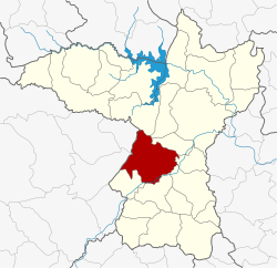
Amphoe Mancha Khiri
|
Mancha Khiri มัญจาคีรี |
|
|---|---|
| Province: | Khon Kaen |
| Surface: | 735.825 km² |
| Residents: | 71,738 (2013) |
| Population density : | 91.7 U / km² |
| ZIP : | 40160 |
| Geocode : | 4017 |
| map | |

|
|
Amphoe Mancha Khiri ( Thai : อำเภอ มัญจาคีรี ) is a district ( amphoe - administrative district) in the province of Khon Kaen . The province of Khon Kaen is located in the northeast region of Thailand , the so-called Isan .
geography
Neighboring counties (clockwise from north): the Amphoe Nong Ruea , Ban Fang , Phra Yuen , Ban Haet , Ban Phai , Chonnabot and Khok Pho Chai in the province of Khon Kaen, and the Amphoe Kaeng Khro and Ban Thaen in the province of Chaiyaphum .
history
The district was renamed from Kut Khao to Mancha Khiri in 1939.
Administrative units
Provincial Administration
The district of Mancha Khiri is divided into eight tambon ("subdistricts" or "municipalities"), which are further subdivided into 116 muban ("villages").
| No. | Surname | Thai | Muban | Pop. |
|---|---|---|---|---|
| 1. | Kut Khao | กุด เค้า | 14th | 12,978 |
| 2. | Suan Mon | สวน หม่อน | 14th | 7,641 |
| 3. | Nong Paen | หนอง แป น | 16 | 8,871 |
| 4th | Phon Phek | โพน เพ็ก | 13 | 7,996 |
| 5. | Kham Khaen | คำ แคน | 2 | 9,051 |
| 6th | Well kha | นา ข่า | 17th | 9,669 |
| 7th | Well ngam | นา งาม | 14th | 7,919 |
| 10. | Tha Sala | ท่าศาลา | - | 7,613 |
Notes: The missing numbers (geocodes) belong to the tambon that belong to the Amphoe Khok Pho Chai today.
Some of the Muban's data are not yet available.
Local administration
There is one municipality with "small town" status ( Thesaban Tambon ) in the district:
- Mancha Khiri (Thai: เทศบาล ตำบล มัญจาคีรี ), consisting of parts of the Tambon Kut Khao.
There are also seven " Tambon Administrative Organizations " ( องค์การ บริหาร ส่วน ตำบล - Tambon Administrative Organizations, TAO):
- Kut Khao (Thai: องค์การ บริหาร ส่วน ตำบล กุด เค้า )
- Suan Mon (Thai: องค์การ บริหาร ส่วน ตำบล สวน หม่อน )
- Nong Paen (Thai: องค์การ บริหาร ส่วน ตำบล หนอง แป น )
- Phon Phek (Thai: องค์การ บริหาร ส่วน ตำบล โพน เพ็ก )
- Kham Khaen (Thai: องค์การ บริหาร ส่วน ตำบล คำ แคน )
- Na Ngam (Thai: องค์การ บริหาร ส่วน ตำบล นา งาม )
- Tha Sala (Thai: องค์การ บริหาร ส่วน ตำบล ท่าศาลา )
Individual evidence
- ↑ พระราชกฤษฎีกา เปลี่ยน นาม อำเภอ กิ่ง อำเภอ และ ตำบล บาง แห่ง พุทธศักราช ๒๔๘๒ . In: Royal Gazette . 56, No. 0 ก , April 17, 1939, pp. 354-364. Retrieved March 21, 2014.
- ↑ 2013 population statistics ( Thai ) Department of Provincial Administration. Retrieved July 29, 2014.
Web links
Coordinates: 16 ° 8 ' N , 102 ° 33' E
