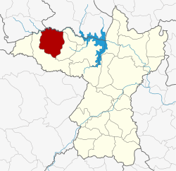
Si Chomphu district
|
Si Chomphu สีชมพู |
|
|---|---|
| Province: | Khon Kaen |
| Surface: | 529.041 km² |
| Residents: | 78,268 (2013) |
| Population density : | 147.9 U / km² |
| ZIP : | 40220 |
| Geocode : | 4006 |
| map | |

|
|
Amphoe Si Chomphu ( Thai : อำเภอ สีชมพู ) is a district ( amphoe - administrative district) in the province of Khon Kaen . The province of Khon Kaen is located in the northeast region of Thailand , the so-called Isan .
geography
Adjacent counties (from north in a clockwise direction): Amphoe Si Bun Rueang the province Nong Bua Lamphu , the Amphoe Nong Na Kham , Wiang Kao and Chum Phae in the province of Khon Kaen and Amphoe Phu Kradueng the Loei province .
history
Si Chomphu was initially set up as a “branch circle” ( King Amphoe ) on July 1, 1965 , by separating the three tambon Si Suk, Si Chomphu and Na Chan from the Chum Phae district . On March 1, 1969, it was promoted to Amphoe.
The name of the district was originally “ ศรี ชมพู ” in Thai , but it was also pronounced “Si Chomphu”.
Administrative units
Provincial Administration
Si Chomphu County is divided into ten tambon ("subdistricts" or "parishes"), which are further divided into 81 muban ("villages").
| No. | Surname | Thai | Muban | Pop. |
|---|---|---|---|---|
| 1. | Si Chomphu | สีชมพู | 4th | 8,963 |
| 2. | Si Suk | ศรีสุข | 15th | 10,944 |
| 3. | Well Chan | นา จาน | 15th | 9,994 |
| 4th | Wang Phoem | วัง เพิ่ม | 4th | 11.602 |
| 5. | Sam Yang | ซำ ยาง | 6th | 3,958 |
| 6th | Nong Daeng | หนอง แดง | 11 | 7,328 |
| 7th | Dong Lan | ดง ลาน | 11 | 7,606 |
| 8th. | Boribun | บริบูรณ์ | - | 7.184 |
| 9. | Ban Mai | บ้าน ใหม่ | 4th | 5,718 |
| 10. | Phu Han | ภู ห่าน | - | 4,971 |
Note: Some of the Muban's data are not yet available.
Local administration
There are three municipalities with "small town" status ( Thesaban Tambon ) in the district:
- Na Chan (Thai: เทศบาล ตำบล นา จาน ), consisting of the entire tambon Na Chan.
- Wang Phoem (Thai: เทศบาล ตำบล วัง เพิ่ม ), consisting of parts of the tambon Wang Phoem.
- Si Chomphu (Thai: เทศบาล ตำบล สีชมพู ), consisting of further parts of the Tambon Wang Phoem.
There are also eight " Tambon Administrative Organizations " ( องค์การ บริหาร ส่วน ตำบล - Tambon Administrative Organizations, TAO):
- Si Chomphu (Thai: องค์การ บริหาร ส่วน ตำบล สีชมพู )
- Si Suk (Thai: องค์การ บริหาร ส่วน ตำบล ศรีสุข )
- Sam Yang (Thai: องค์การ บริหาร ส่วน ตำบล ซำ ยาง )
- Nong Daeng (Thai: องค์การ บริหาร ส่วน ตำบล หนอง แดง )
- Dong Lan (Thai: องค์การ บริหาร ส่วน ตำบล ดง ลาน )
- Boribun (Thai: องค์การ บริหาร ส่วน ตำบล บริบูรณ์ )
- Ban Mai (Thai: องค์การ บริหาร ส่วน ตำบล บ้าน ใหม่ )
- Phu Han (Thai: องค์การ บริหาร ส่วน ตำบล ภู ห่าน )
Individual evidence
- ↑ ประกาศ กระทรวง มหาดไทย เรื่อง แบ่ง ท้องที่ ตั้ง เป็น กิ่ง อำเภอ . In: Royal Gazette . 83, No. 59 ง , July 12, 1965, p. 2260.
- ↑ พระราชกฤษฎีกา จัดตั้ง อำเภอ สมเด็จ อำเภอ สีชมพู อำเภอ หนองบัวแดง อำเภอ บ้านแท่น อำเภอ ดอนตูม อำเภอ นากลาง อำเภอ ศรีบุญเรือง และ อำเภอ ป่าติ้ว พ.ศ. ๒๕๑๒ . In: Royal Gazette . 86, No. 16 ก , February 25, 1969, pp. 225-229.
- ↑ 2013 population statistics ( Thai ) Department of Provincial Administration. Retrieved July 29, 2014.
Web links
Coordinates: 16 ° 48 ' N , 102 ° 11' E
